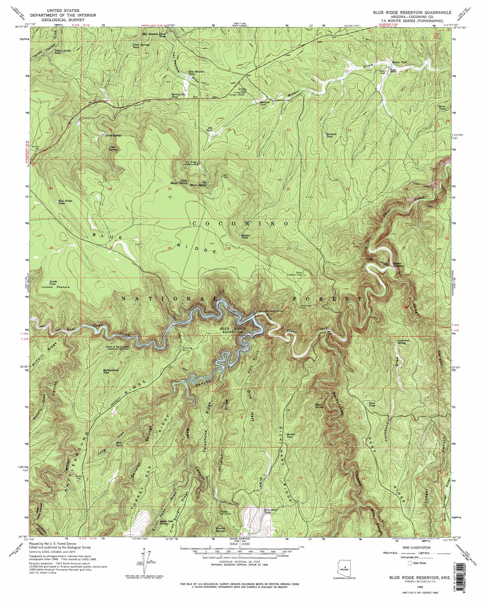
Blue Ridge Reservoir Topo Map Arizona
To zoom in, hover over the map of Blue Ridge Reservoir
USGS Topo Quad 34111e2 - 1:24,000 scale
| Topo Map Name: | Blue Ridge Reservoir |
| USGS Topo Quad ID: | 34111e2 |
| Print Size: | ca. 21 1/4" wide x 27" high |
| Southeast Coordinates: | 34.5° N latitude / 111.125° W longitude |
| Map Center Coordinates: | 34.5625° N latitude / 111.1875° W longitude |
| U.S. State: | AZ |
| Filename: | o34111e2.jpg |
| Download Map JPG Image: | Blue Ridge Reservoir topo map 1:24,000 scale |
| Map Type: | Topographic |
| Topo Series: | 7.5´ |
| Map Scale: | 1:24,000 |
| Source of Map Images: | United States Geological Survey (USGS) |
| Alternate Map Versions: |
Blue Ridge Reservoir AZ 1965, updated 1967 Download PDF Buy paper map Blue Ridge Reservoir AZ 1965, updated 1975 Download PDF Buy paper map Blue Ridge Reservoir AZ 1965, updated 1975 Download PDF Buy paper map C.C. Cragin Reservoir AZ 2011 Download PDF Buy paper map C.C. Cragin Reservoir AZ 2014 Download PDF Buy paper map |
| FStopo: | US Forest Service topo C C Craigin Reservoir is available: Download FStopo PDF Download FStopo TIF |
1:24,000 Topo Quads surrounding Blue Ridge Reservoir
Hutch Mountain |
Jaycox Mountain |
Chavez Mountain West |
Chavez Mountain East |
Sunset Pass |
Happy Jack |
Turkey Mountain |
Hay Lake |
Quayle Hill |
Hamilton Crossing |
Calloway Butte |
Long Valley |
Blue Ridge Reservoir |
Leonard Canyon |
Grama Draw |
Pine |
Kehl Ridge |
Dane Canyon |
Knoll Lake |
Porcupine Ridge |
Buckhead Mesa |
Payson North |
Diamond Point |
Promontory Butte |
Woods Canyon |
> Back to 34111e1 at 1:100,000 scale
> Back to 34110a1 at 1:250,000 scale
> Back to U.S. Topo Maps home
Blue Ridge Reservoir topo map: Gazetteer
Blue Ridge Reservoir: Arroyos
Lockwood Draw elevation 2094m 6870′Blue Ridge Reservoir: Crossings
Rock Crossing elevation 2065m 6774′Blue Ridge Reservoir: Dams
C.C. Cragin Dam elevation 2040m 6692′Blue Ridge Reservoir: Flats
Jumbo Pasture elevation 2231m 7319′Blue Ridge Reservoir: Lakes
Barber Lake elevation 2179m 7148′Blue Ridge Reservoir: Parks
Battle of Big Dry Wash Historical Monument elevation 2127m 6978′Blue Ridge Reservoir: Populated Places
Horse Crossing elevation 1950m 6397′Kinder Crossing elevation 1963m 6440′
Little Spring elevation 2134m 7001′
Blue Ridge Reservoir: Reservoirs
Battleground Tank elevation 2121m 6958′Bell Tank elevation 2159m 7083′
Birthday Tank elevation 2168m 7112′
Blue Ridge Tank elevation 2211m 7253′
Borrow Pit Tank elevation 2089m 6853′
C.C. Cragin Reservoir elevation 2010m 6594′
Dane Tank elevation 2174m 7132′
Dick Hart Tank elevation 2157m 7076′
Dink Tank elevation 2238m 7342′
Elk Tank elevation 2098m 6883′
Granada Tank elevation 2150m 7053′
Hancock Tank elevation 2075m 6807′
Hay Meadow Draw Tank elevation 2047m 6715′
Hay Meadow Tank elevation 2067m 6781′
Horse Tank elevation 2046m 6712′
Hunter Tank elevation 2194m 7198′
Jumbo Tank elevation 2223m 7293′
Little Springs Tank elevation 2054m 6738′
Mackin Tank elevation 2180m 7152′
Moqui Tank elevation 2045m 6709′
Mountan Tank elevation 2149m 7050′
O D Tank elevation 2046m 6712′
Oak Tank elevation 2218m 7276′
Rush Tank elevation 2077m 6814′
Sawmill Tank elevation 2079m 6820′
Section Twentyseven Tank elevation 2200m 7217′
Sinkhole Tank elevation 2235m 7332′
Still Tank elevation 2204m 7230′
Topsoil Tank elevation 2086m 6843′
Water Right Tank elevation 2224m 7296′
Well Tank elevation 2097m 6879′
Yellow Jacket Tank elevation 2059m 6755′
Blue Ridge Reservoir: Ridges
Battleground Ridge elevation 2175m 7135′Telephone Ridge elevation 2180m 7152′
Turkey Pen Ridge elevation 2138m 7014′
Blue Ridge Reservoir: Springs
Big Moqui Spring elevation 2185m 7168′Little Moqui Spring elevation 2186m 7171′
Little Spring elevation 2141m 7024′
Lockwood Spring elevation 2087m 6847′
Pinchot Springs elevation 2146m 7040′
Quail Spring elevation 2093m 6866′
Quien Sabe Spring elevation 2142m 7027′
Blue Ridge Reservoir: Summits
Hart Point elevation 2165m 7103′Blue Ridge Reservoir: Trails
Horse Crossing Trail elevation 1950m 6397′Kinder Crossing Trail elevation 2050m 6725′
Rock Crossing Trail elevation 2160m 7086′
Blue Ridge Reservoir: Valleys
Barbershop Canyon elevation 1990m 6528′Bear Canyon elevation 2044m 6706′
Crackerbox Canyon elevation 2132m 6994′
Dane Canyon elevation 2091m 6860′
Dick Hart Draw elevation 2001m 6564′
East Miller Canyon elevation 2198m 7211′
General Springs Canyon elevation 2010m 6594′
Hay Meadow Draw elevation 2040m 6692′
Houston Draw elevation 2030m 6660′
Long Draw elevation 2066m 6778′
McCarty Draw elevation 2071m 6794′
McClintock Draw elevation 2109m 6919′
Miller Canyon elevation 2191m 7188′
Quien Sabe Draw elevation 2067m 6781′
Yeager Canyon elevation 1963m 6440′
Blue Ridge Reservoir digital topo map on disk
Buy this Blue Ridge Reservoir topo map showing relief, roads, GPS coordinates and other geographical features, as a high-resolution digital map file on DVD: