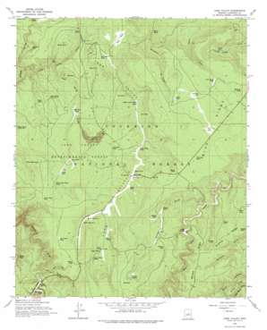
Long Valley Topo Map Arizona
To zoom in, hover over the map of Long Valley
USGS Topo Quad 34111e3 - 1:24,000 scale
| Topo Map Name: | Long Valley |
| USGS Topo Quad ID: | 34111e3 |
| Print Size: | ca. 21 1/4" wide x 27" high |
| Southeast Coordinates: | 34.5° N latitude / 111.25° W longitude |
| Map Center Coordinates: | 34.5625° N latitude / 111.3125° W longitude |
| U.S. State: | AZ |
| Filename: | o34111e3.jpg |
| Download Map JPG Image: | Long Valley topo map 1:24,000 scale |
| Map Type: | Topographic |
| Topo Series: | 7.5´ |
| Map Scale: | 1:24,000 |
| Source of Map Images: | United States Geological Survey (USGS) |
| Alternate Map Versions: |
Long Valley AZ 1965, updated 1967 Download PDF Buy paper map Long Valley AZ 1965, updated 1975 Download PDF Buy paper map Long Valley AZ 1965, updated 1975 Download PDF Buy paper map Long Valley AZ 2011 Download PDF Buy paper map Long Valley AZ 2014 Download PDF Buy paper map |
| FStopo: | US Forest Service topo Long Valley is available: Download FStopo PDF Download FStopo TIF |
1:24,000 Topo Quads surrounding Long Valley
> Back to 34111e1 at 1:100,000 scale
> Back to 34110a1 at 1:250,000 scale
> Back to U.S. Topo Maps home
Long Valley topo map: Gazetteer
Long Valley: Flats
Bald Mesa elevation 2156m 7073′The Park elevation 2183m 7162′
Long Valley: Forests
Long Valley Experimental Forest elevation 2096m 6876′Long Valley: Lakes
Dry Lake elevation 2214m 7263′McClure Lake elevation 2177m 7142′
Long Valley: Mines
Last Chance Mine elevation 2081m 6827′Long Valley: Populated Places
Clints Well elevation 2089m 6853′Jones Crossing elevation 2093m 6866′
Long Valley elevation 2122m 6961′
Wingfield elevation 2080m 6824′
Long Valley: Reservoirs
Aculpulco Tank elevation 2124m 6968′Aswan Tank elevation 2106m 6909′
Back Tank elevation 2075m 6807′
Bald Mesa Tank elevation 2098m 6883′
Basin Tank elevation 2104m 6902′
Billys Tank elevation 2121m 6958′
Blazed Tank elevation 2137m 7011′
Blazed Tank elevation 2116m 6942′
Brockie Tank elevation 2025m 6643′
Cart Cabin Tank elevation 2158m 7080′
Chilson Mesa Tank elevation 2128m 6981′
Clark Tank elevation 2172m 7125′
Clearcut Tank elevation 2138m 7014′
Clints Tank elevation 2166m 7106′
Clover Point Tank elevation 2133m 6998′
Clover Tank elevation 2079m 6820′
Cobble Tank elevation 2176m 7139′
Dirtyneck Tank elevation 2106m 6909′
Driveway Tank elevation 2183m 7162′
East Tank elevation 2050m 6725′
Fain Tank elevation 2025m 6643′
Fuller Tank elevation 2102m 6896′
Godard Tank elevation 2122m 6961′
Hanks Tank elevation 2163m 7096′
Heath Tank Number One elevation 2098m 6883′
Heath Tank Number Two elevation 2099m 6886′
Highway Tank elevation 2188m 7178′
Hoe Tank elevation 2044m 6706′
Hoot Tank elevation 2168m 7112′
Jims Tank elevation 2083m 6833′
Joes Tank elevation 2092m 6863′
Joes Tank elevation 2079m 6820′
Kelley Tank elevation 2065m 6774′
Kinder Tank elevation 2120m 6955′
Lake of the Woods Tank elevation 2092m 6863′
Long Valley Tank elevation 2083m 6833′
Lost Eden Tank elevation 2049m 6722′
M Diamond Tank elevation 2074m 6804′
Macks Tank elevation 2059m 6755′
Marys Tank elevation 2085m 6840′
Marys Tank elevation 2071m 6794′
Mickey Tank elevation 2071m 6794′
Middle Tank elevation 2062m 6765′
Mine Tank elevation 2060m 6758′
Natural Tank elevation 2183m 7162′
Nells Tank elevation 2092m 6863′
Pecks Point Tank Number Two elevation 2060m 6758′
Pigman Tank elevation 2135m 7004′
Roadside Tank elevation 2080m 6824′
Rock Tank elevation 2127m 6978′
Ronnys Tank elevation 2150m 7053′
Section 26 Tank elevation 2208m 7244′
Sherman Tank elevation 2146m 7040′
Sink Hole Number One Tank elevation 2178m 7145′
Snafu Tank elevation 2056m 6745′
Telephone Tank elevation 2102m 6896′
Thicket Tank elevation 2168m 7112′
Todd Draw Tank elevation 2171m 7122′
Turkey Tank elevation 2159m 7083′
Upper Long Valley Tank elevation 2073m 6801′
Wolf Hole Tank elevation 2064m 6771′
Long Valley: Ridges
Blue Ridge elevation 2202m 7224′McCarty Ridge elevation 2161m 7089′
Long Valley: Springs
Clover Spring elevation 2089m 6853′Kinder Spring elevation 2174m 7132′
Long Valley Spring elevation 2133m 6998′
Long Valley: Valleys
Dirtyneck Canyon elevation 2086m 6843′Iron Mine Draw elevation 2025m 6643′
Kinder Draw elevation 2093m 6866′
Long Valley elevation 2049m 6722′
Long Valley Draw elevation 2005m 6578′
Snake Draw elevation 2084m 6837′
Long Valley digital topo map on disk
Buy this Long Valley topo map showing relief, roads, GPS coordinates and other geographical features, as a high-resolution digital map file on DVD:


