Middle Verde Topo Map Arizona
To zoom in, hover over the map of Middle Verde
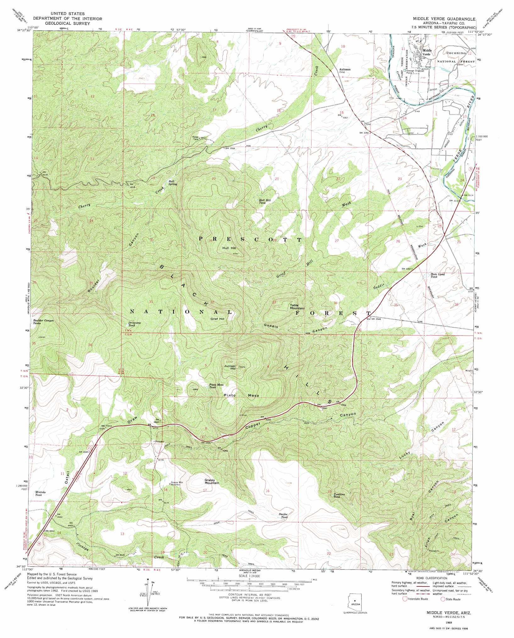
USGS Topo Quad 34111e8 - 1:24,000 scale
| Topo Map Name: | Middle Verde |
| USGS Topo Quad ID: | 34111e8 |
| Print Size: | ca. 21 1/4" wide x 27" high |
| Southeast Coordinates: | 34.5° N latitude / 111.875° W longitude |
| Map Center Coordinates: | 34.5625° N latitude / 111.9375° W longitude |
| U.S. State: | AZ |
| Filename: | o34111e8.jpg |
| Download Map JPG Image: | Middle Verde topo map 1:24,000 scale |
| Map Type: | Topographic |
| Topo Series: | 7.5´ |
| Map Scale: | 1:24,000 |
| Source of Map Images: | United States Geological Survey (USGS) |
| Alternate Map Versions: |
Middle Verde AZ 1969, updated 1971 Download PDF Buy paper map Middle Verde AZ 1969, updated 1971 Download PDF Buy paper map Middle Verde AZ 2012 Download PDF Buy paper map Middle Verde AZ 2014 Download PDF Buy paper map |
| FStopo: | US Forest Service topo Middle Verde is available: Download FStopo PDF Download FStopo TIF |
1:24,000 Topo Quads surrounding Middle Verde
Munds Draw |
Clarkdale |
Page Springs |
Sedona |
Munds Mountain |
Hickey Mountain |
Cottonwood |
Cornville |
Lake Montezuma |
Casner Butte |
Humboldt |
Cherry |
Middle Verde |
Camp Verde |
Walker Mountain |
Mayer |
Estler Peak |
Arnold Mesa |
Horner Mountain |
Hackberry Mountain |
Cleator |
Cordes Junction |
Dugas |
Tule Mesa |
Verde Hot Springs |
> Back to 34111e1 at 1:100,000 scale
> Back to 34110a1 at 1:250,000 scale
> Back to U.S. Topo Maps home
Middle Verde topo map: Gazetteer
Middle Verde: Canals
Eureka Ditch elevation 952m 3123′Middle Verde: Populated Places
Aultman elevation 1000m 3280′Flower Pot elevation 1386m 4547′
Middle Verde elevation 967m 3172′
Middle Verde: Reservoirs
Boulder Canyon Tank Number Two elevation 1663m 5456′CF Tank elevation 1508m 4947′
Corief Hill Water Tank elevation 1157m 3795′
Driveway Tank elevation 1513m 4963′
Durfee Tank elevation 1506m 4940′
Flowerpot Tank elevation 1389m 4557′
Grief Hill Tank elevation 1161m 3809′
Hull Hill Tank elevation 1246m 4087′
Hull Hill Tank Number Two elevation 1127m 3697′
Loco Tank elevation 1049m 3441′
Lucky Canyon Tanks elevation 1014m 3326′
Mistake Tank elevation 1365m 4478′
Oxtail Tank elevation 1500m 4921′
Pinto Mesa Tank elevation 1485m 4872′
State Land Tank elevation 988m 3241′
Tomkins Tank elevation 1444m 4737′
Middle Verde: Ridges
Pinto Mesa elevation 1503m 4931′Middle Verde: Springs
Copper Canyon Water elevation 1306m 4284′Gaddis Canyon Spring elevation 1205m 3953′
Grief Hill Water elevation 1243m 4078′
Grief Hills Spring Number One elevation 1248m 4094′
Hull Spring elevation 1106m 3628′
Hull Water elevation 1180m 3871′
Pinto Mesa Spring elevation 1242m 4074′
Ryal Water elevation 1448m 4750′
Upper Lucky Canyon Spring elevation 1147m 3763′
Middle Verde: Streams
Gaddis Wash elevation 952m 3123′Grief Hill Wash elevation 952m 3123′
Middle Verde: Summits
Black Hills elevation 1387m 4550′Grassy Mountain elevation 1567m 5141′
Grief Hill elevation 1628m 5341′
Hull Hill elevation 1434m 4704′
Juniper Hill elevation 1635m 5364′
Table Mountain elevation 1407m 4616′
Middle Verde: Valleys
Boulder Canyon elevation 1134m 3720′Gaddis Canyon elevation 1045m 3428′
Oxtail Draw elevation 1354m 4442′
Middle Verde: Wells
Bates Well elevation 1402m 4599′Cherry Creek Well elevation 1110m 3641′
Cienega Well elevation 1427m 4681′
Lucky Canyon Windmill elevation 1044m 3425′
Wool Growers Windmill elevation 1427m 4681′
Middle Verde digital topo map on disk
Buy this Middle Verde topo map showing relief, roads, GPS coordinates and other geographical features, as a high-resolution digital map file on DVD: