Hay Lake Topo Map Arizona
To zoom in, hover over the map of Hay Lake
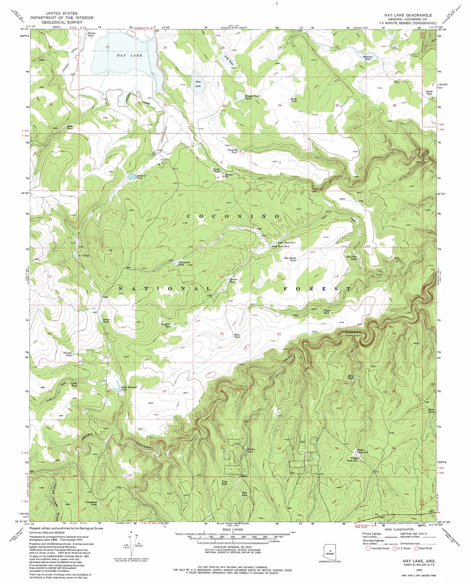
USGS Topo Quad 34111f2 - 1:24,000 scale
| Topo Map Name: | Hay Lake |
| USGS Topo Quad ID: | 34111f2 |
| Print Size: | ca. 21 1/4" wide x 27" high |
| Southeast Coordinates: | 34.625° N latitude / 111.125° W longitude |
| Map Center Coordinates: | 34.6875° N latitude / 111.1875° W longitude |
| U.S. State: | AZ |
| Filename: | o34111f2.jpg |
| Download Map JPG Image: | Hay Lake topo map 1:24,000 scale |
| Map Type: | Topographic |
| Topo Series: | 7.5´ |
| Map Scale: | 1:24,000 |
| Source of Map Images: | United States Geological Survey (USGS) |
| Alternate Map Versions: |
Hay Lake AZ 1970, updated 1973 Download PDF Buy paper map Hay Lake AZ 1970, updated 1983 Download PDF Buy paper map Hay Lake AZ 1970, updated 1983 Download PDF Buy paper map Hay Lake AZ 2011 Download PDF Buy paper map Hay Lake AZ 2014 Download PDF Buy paper map |
| FStopo: | US Forest Service topo Hay Lake is available: Download FStopo PDF Download FStopo TIF |
1:24,000 Topo Quads surrounding Hay Lake
Mormon Lake |
Kinnikinick Lake |
Chavez Mountain Nw |
Chavez Mountain Ne |
West Sunset Mountain |
Hutch Mountain |
Jaycox Mountain |
Chavez Mountain West |
Chavez Mountain East |
Sunset Pass |
Happy Jack |
Turkey Mountain |
Hay Lake |
Quayle Hill |
Hamilton Crossing |
Calloway Butte |
Long Valley |
Blue Ridge Reservoir |
Leonard Canyon |
Grama Draw |
Pine |
Kehl Ridge |
Dane Canyon |
Knoll Lake |
Porcupine Ridge |
> Back to 34111e1 at 1:100,000 scale
> Back to 34110a1 at 1:250,000 scale
> Back to U.S. Topo Maps home
Hay Lake topo map: Gazetteer
Hay Lake: Canals
Chilson Canal elevation 2049m 6722′Hay Lake: Dams
Hay Lake Dam elevation 2040m 6692′Hay Lake: Forests
Blue Ridge Ranger District elevation 2063m 6768′Hay Lake: Lakes
Daze Lake elevation 2052m 6732′Hay Lake: Reservoirs
Bawcom Tank elevation 2049m 6722′Big Rock Tank elevation 2068m 6784′
Boulder Tank elevation 2086m 6843′
Buck Tank elevation 2058m 6751′
Chilson Tank elevation 2043m 6702′
Cowhead Tank elevation 2043m 6702′
Coyote Tank elevation 2022m 6633′
Daze Tank elevation 2059m 6755′
Dogie Tank elevation 2035m 6676′
Duke Tank Number One elevation 2036m 6679′
Duke Tank Number Two elevation 2036m 6679′
Fish and Game elevation 2076m 6811′
Fisher Tank Number One elevation 2049m 6722′
Fisher Tank Number Two elevation 2046m 6712′
Fourteen Tank elevation 2008m 6587′
Freight Trail Tank elevation 2061m 6761′
Green Howard Tank elevation 2051m 6729′
Green Tank elevation 2061m 6761′
Hay Lake elevation 2040m 6692′
Hidden Tank elevation 2040m 6692′
Hide Tank elevation 2059m 6755′
Janice Tank elevation 2085m 6840′
Judy Tank elevation 2060m 6758′
Kens Tank elevation 2010m 6594′
Limestone Tank elevation 2048m 6719′
Melatone Tank elevation 2022m 6633′
Mesa Tank elevation 2052m 6732′
Natural Tank elevation 1996m 6548′
Pieper Tank elevation 2023m 6637′
Plantation Tank elevation 2066m 6778′
PW Tank elevation 2131m 6991′
Sha Donde Tank elevation 2055m 6742′
Sha Donde Tank elevation 2055m 6742′
Sixteen Tank elevation 2042m 6699′
Thistle Tank elevation 2043m 6702′
Tiny Tank elevation 2058m 6751′
Woods Tank elevation 2040m 6692′
Y-seven Tank elevation 2072m 6797′
Hay Lake: Valleys
Yellow Jacket Draw elevation 2035m 6676′Hay Lake digital topo map on disk
Buy this Hay Lake topo map showing relief, roads, GPS coordinates and other geographical features, as a high-resolution digital map file on DVD: