Chavez Mountain West Topo Map Arizona
To zoom in, hover over the map of Chavez Mountain West
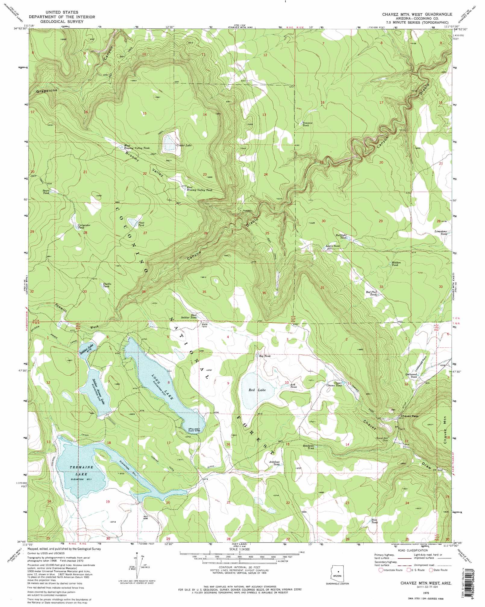
USGS Topo Quad 34111g2 - 1:24,000 scale
| Topo Map Name: | Chavez Mountain West |
| USGS Topo Quad ID: | 34111g2 |
| Print Size: | ca. 21 1/4" wide x 27" high |
| Southeast Coordinates: | 34.75° N latitude / 111.125° W longitude |
| Map Center Coordinates: | 34.8125° N latitude / 111.1875° W longitude |
| U.S. State: | AZ |
| Filename: | o34111g2.jpg |
| Download Map JPG Image: | Chavez Mountain West topo map 1:24,000 scale |
| Map Type: | Topographic |
| Topo Series: | 7.5´ |
| Map Scale: | 1:24,000 |
| Source of Map Images: | United States Geological Survey (USGS) |
| Alternate Map Versions: |
Chavez Mtn West AZ 1970, updated 1973 Download PDF Buy paper map Chavez Mtn West AZ 1970, updated 1986 Download PDF Buy paper map Chavez Mtn West AZ 1970, updated 1986 Download PDF Buy paper map Chavez Mountain West AZ 2011 Download PDF Buy paper map Chavez Mountain West AZ 2014 Download PDF Buy paper map |
| FStopo: | US Forest Service topo Chavez Mountain West is available: Download FStopo PDF Download FStopo TIF |
1:24,000 Topo Quads surrounding Chavez Mountain West
Ashurst Lake |
Elliott Canyon |
Anderson Canyon |
Meteor Crater |
Tucker Mesa Sw |
Mormon Lake |
Kinnikinick Lake |
Chavez Mountain Nw |
Chavez Mountain Ne |
West Sunset Mountain |
Hutch Mountain |
Jaycox Mountain |
Chavez Mountain West |
Chavez Mountain East |
Sunset Pass |
Happy Jack |
Turkey Mountain |
Hay Lake |
Quayle Hill |
Hamilton Crossing |
Calloway Butte |
Long Valley |
Blue Ridge Reservoir |
Leonard Canyon |
Grama Draw |
> Back to 34111e1 at 1:100,000 scale
> Back to 34110a1 at 1:250,000 scale
> Back to U.S. Topo Maps home
Chavez Mountain West topo map: Gazetteer
Chavez Mountain West: Basins
Broomy Valley elevation 2075m 6807′Chavez Mountain West: Dams
Soldier Annex Dam elevation 2063m 6768′Chavez Mountain West: Flats
Lockwood Park elevation 1933m 6341′Chavez Mountain West: Gaps
Chavez Pass elevation 1988m 6522′Chavez Mountain West: Lakes
Crater Lake elevation 2064m 6771′Pratt Tank elevation 2090m 6856′
Red Lake elevation 2034m 6673′
Chavez Mountain West: Reservoirs
Antelope Tank elevation 2035m 6676′Ash Tank elevation 2036m 6679′
Bog Tank elevation 2035m 6676′
Borrow Tank elevation 2067m 6781′
Bullfight Tank elevation 1916m 6286′
Carpenter Tank elevation 2085m 6840′
Diablo Tank elevation 2061m 6761′
East Broomy Valley Tank elevation 2057m 6748′
East Soldier Tank elevation 2061m 6761′
Hidden Tank elevation 1902m 6240′
Lewis Tank elevation 1932m 6338′
Limestone Tank elevation 1877m 6158′
Lockwood Tank elevation 1941m 6368′
Long Lake elevation 2054m 6738′
Natural Tank elevation 2042m 6699′
Pratt Tank elevation 2091m 6860′
Red Flat Tank elevation 1921m 6302′
Rice Tank elevation 2013m 6604′
Roadside Tank elevation 2022m 6633′
Sears Tank elevation 2109m 6919′
Soldier Annex Lake elevation 2067m 6781′
Soldier Lake elevation 2068m 6784′
Tommie Tank elevation 1906m 6253′
Tremaine Lake elevation 2046m 6712′
Upper Chavez Tank elevation 2033m 6669′
Upper Diablo Tank elevation 2085m 6840′
West Broomy Valley Tank elevation 2066m 6778′
Chavez Mountain West: Streams
Antelope Tank Ditch elevation 2034m 6673′Sawmill Wash elevation 2042m 6699′
Chavez Mountain West: Wells
Chavez Well elevation 1970m 6463′Chavez Mountain West digital topo map on disk
Buy this Chavez Mountain West topo map showing relief, roads, GPS coordinates and other geographical features, as a high-resolution digital map file on DVD: