Stoneman Lake Topo Map Arizona
To zoom in, hover over the map of Stoneman Lake
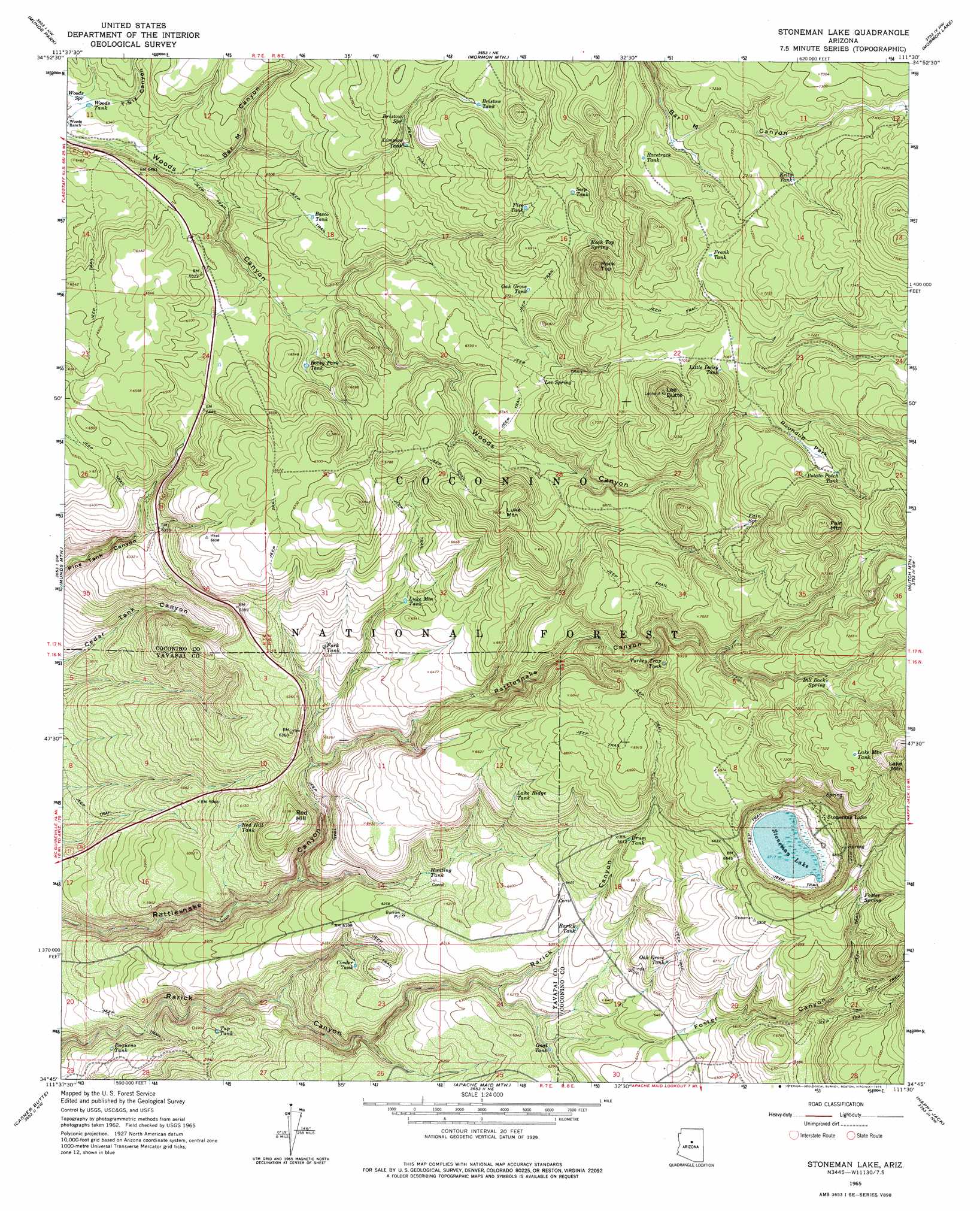
USGS Topo Quad 34111g5 - 1:24,000 scale
| Topo Map Name: | Stoneman Lake |
| USGS Topo Quad ID: | 34111g5 |
| Print Size: | ca. 21 1/4" wide x 27" high |
| Southeast Coordinates: | 34.75° N latitude / 111.5° W longitude |
| Map Center Coordinates: | 34.8125° N latitude / 111.5625° W longitude |
| U.S. State: | AZ |
| Filename: | o34111g5.jpg |
| Download Map JPG Image: | Stoneman Lake topo map 1:24,000 scale |
| Map Type: | Topographic |
| Topo Series: | 7.5´ |
| Map Scale: | 1:24,000 |
| Source of Map Images: | United States Geological Survey (USGS) |
| Alternate Map Versions: |
Stoneman Lake AZ 1965, updated 1967 Download PDF Buy paper map Stoneman Lake AZ 1965, updated 1975 Download PDF Buy paper map Stoneman Lake AZ 1965, updated 1975 Download PDF Buy paper map Stoneman Lake AZ 2011 Download PDF Buy paper map Stoneman Lake AZ 2014 Download PDF Buy paper map |
| FStopo: | US Forest Service topo Stoneman Lake is available: Download FStopo PDF Download FStopo TIF |
1:24,000 Topo Quads surrounding Stoneman Lake
Dutton Hill |
Mountainaire |
Lower Lake Mary |
Ashurst Lake |
Elliott Canyon |
Wilson Mountain |
Munds Park |
Mormon Mountain |
Mormon Lake |
Kinnikinick Lake |
Sedona |
Munds Mountain |
Stoneman Lake |
Hutch Mountain |
Jaycox Mountain |
Lake Montezuma |
Casner Butte |
Apache Maid Mountain |
Happy Jack |
Turkey Mountain |
Camp Verde |
Walker Mountain |
Buckhorn Mountain |
Calloway Butte |
Long Valley |
> Back to 34111e1 at 1:100,000 scale
> Back to 34110a1 at 1:250,000 scale
> Back to U.S. Topo Maps home
Stoneman Lake topo map: Gazetteer
Stoneman Lake: Dams
Weir Number Eight elevation 2147m 7043′Weir Number Nine elevation 2112m 6929′
Weir Number Seven elevation 2059m 6755′
Stoneman Lake: Flats
Gash Flat elevation 2199m 7214′Roundup Park elevation 2161m 7089′
Stoneman Lake: Lakes
Stoneman Lake elevation 2048m 6719′Stoneman Lake: Parks
Potato Patch Park elevation 2191m 7188′Stoneman Lake: Populated Places
Stoneman Lake elevation 2067m 6781′Stoneman Lake: Post Offices
Stoneman Lake Post Office (historical) elevation 2066m 6778′Stoneman Lake: Reservoirs
Basco Tank elevation 1997m 6551′Bristow Tank elevation 2075m 6807′
Chaco Tank elevation 1999m 6558′
Cinder Pit Tank elevation 2256m 7401′
Cinder Tank elevation 1863m 6112′
Cluster Tank elevation 2174m 7132′
Drum Tank elevation 2010m 6594′
Elk Tank elevation 2092m 6863′
Fire Tank elevation 2071m 6794′
Flat Tank elevation 1970m 6463′
Fork Tank elevation 1921m 6302′
Fork Tank elevation 1921m 6302′
Frank Tank elevation 2174m 7132′
Franks Tank elevation 2176m 7139′
Gage Tank elevation 2042m 6699′
Gnat Tank elevation 1912m 6272′
Grady Tank elevation 2032m 6666′
Hopeful Tank elevation 2013m 6604′
Hunting Tank elevation 1894m 6213′
Intersection Tank elevation 2042m 6699′
I-Seventeen Tank elevation 1981m 6499′
Jack Tank elevation 2036m 6679′
Joe Hunt Tank elevation 2080m 6824′
Juniper Tank elevation 2007m 6584′
Kelly Tank elevation 2197m 7208′
Lake Mountain Tank elevation 2235m 7332′
Lake Ridge Tank elevation 2018m 6620′
Lee Butte Tank elevation 2158m 7080′
Limpios Tank elevation 2043m 6702′
Little Daisy Tank elevation 2146m 7040′
Luke Mountain Tank elevation 1965m 6446′
Middle Water Tank elevation 2172m 7125′
Miller Water Tank elevation 2166m 7106′
Oak Grove Tank elevation 2006m 6581′
Oak Grove Tank elevation 2058m 6751′
Paqueno Tank elevation 1732m 5682′
Pine Tank elevation 1902m 6240′
Potato Patch Tank elevation 2168m 7112′
Potato Tank elevation 2180m 7152′
Racetrack Tank elevation 2183m 7162′
Rarick Tank elevation 1945m 6381′
Red Hill Tank elevation 1841m 6040′
Robbers Roost Tank elevation 1945m 6381′
Rocky Park Tank elevation 1967m 6453′
Saddle Tank elevation 2175m 7135′
Salt Lick Tank elevation 2127m 6978′
Seep Tank elevation 2096m 6876′
Shallow Tank elevation 1966m 6450′
Tap Tank elevation 1799m 5902′
Tree Tank elevation 1966m 6450′
Turkey Trap Tank elevation 2098m 6883′
Wier Number Eight Tank elevation 2114m 6935′
Woods Canyon Tank elevation 2029m 6656′
Woods Tank elevation 1931m 6335′
Yellow Jacket Tank elevation 2059m 6755′
Stoneman Lake: Springs
Bill Back Spring elevation 2178m 7145′Bristow Spring elevation 2049m 6722′
Fain Spring elevation 2153m 7063′
Foster Spring elevation 2112m 6929′
Free Spring elevation 2208m 7244′
Lee Spring elevation 2070m 6791′
Rock Top Spring elevation 2123m 6965′
Tree Spring elevation 2208m 7244′
Woods Spring elevation 1930m 6332′
Stoneman Lake: Summits
Fain Mountain elevation 2305m 7562′Lee Butte elevation 2256m 7401′
Luke Mountain elevation 2138m 7014′
Red Hill elevation 1929m 6328′
Rock Top elevation 2242m 7355′
Stoneman Lake: Valleys
Bar M Canyon elevation 1927m 6322′Foster Canyon elevation 1917m 6289′
T-Six Canyon elevation 1932m 6338′
Stoneman Lake digital topo map on disk
Buy this Stoneman Lake topo map showing relief, roads, GPS coordinates and other geographical features, as a high-resolution digital map file on DVD: