Munds Mountain Topo Map Arizona
To zoom in, hover over the map of Munds Mountain
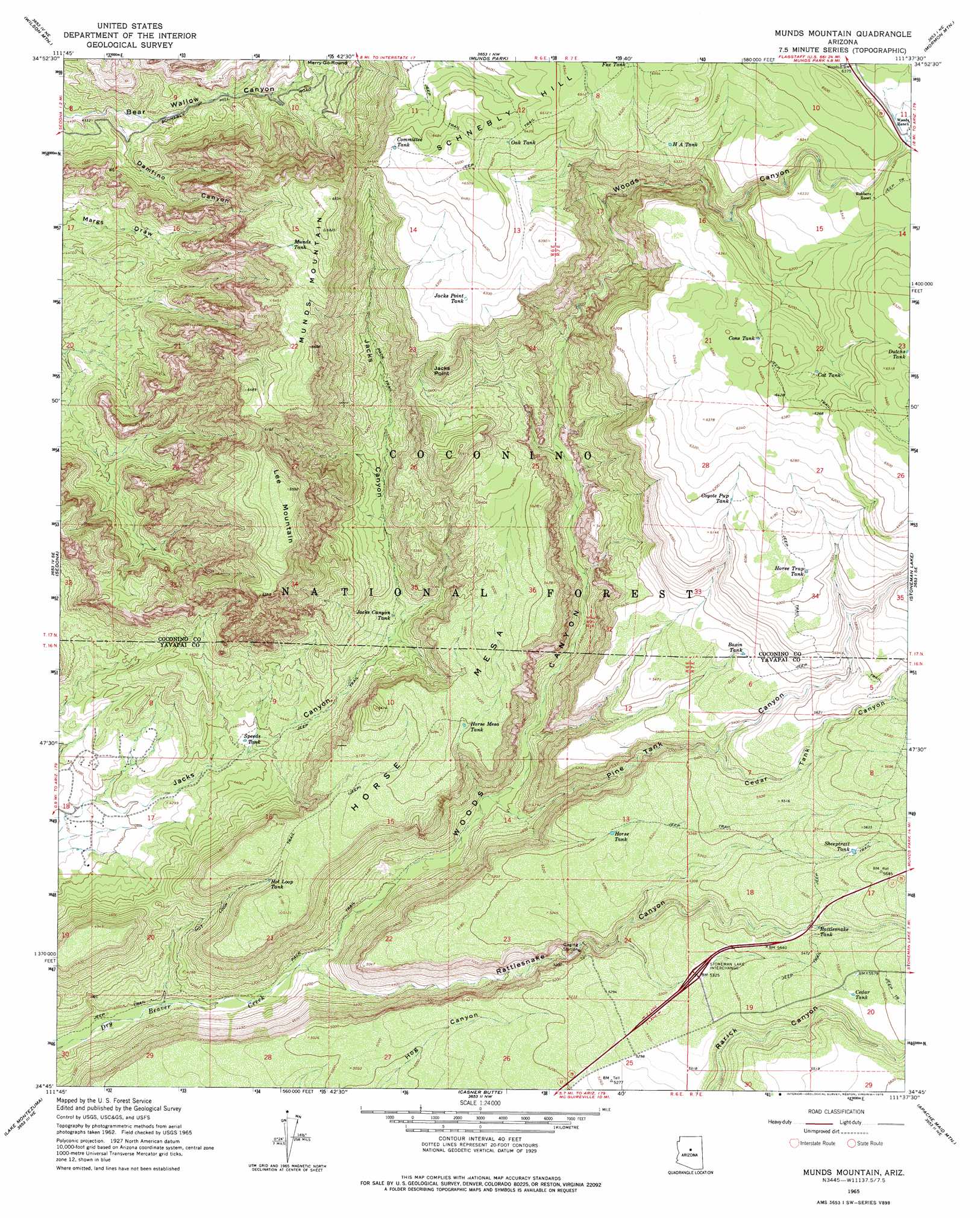
USGS Topo Quad 34111g6 - 1:24,000 scale
| Topo Map Name: | Munds Mountain |
| USGS Topo Quad ID: | 34111g6 |
| Print Size: | ca. 21 1/4" wide x 27" high |
| Southeast Coordinates: | 34.75° N latitude / 111.625° W longitude |
| Map Center Coordinates: | 34.8125° N latitude / 111.6875° W longitude |
| U.S. State: | AZ |
| Filename: | o34111g6.jpg |
| Download Map JPG Image: | Munds Mountain topo map 1:24,000 scale |
| Map Type: | Topographic |
| Topo Series: | 7.5´ |
| Map Scale: | 1:24,000 |
| Source of Map Images: | United States Geological Survey (USGS) |
| Alternate Map Versions: |
Munds Mountain AZ 1965, updated 1967 Download PDF Buy paper map Munds Mountain AZ 1965, updated 1975 Download PDF Buy paper map Munds Mountain AZ 1965, updated 1975 Download PDF Buy paper map Munds Mountain AZ 2011 Download PDF Buy paper map Munds Mountain AZ 2014 Download PDF Buy paper map |
| FStopo: | US Forest Service topo Munds Mountain is available: Download FStopo PDF Download FStopo TIF |
1:24,000 Topo Quads surrounding Munds Mountain
Sycamore Point |
Dutton Hill |
Mountainaire |
Lower Lake Mary |
Ashurst Lake |
Loy Butte |
Wilson Mountain |
Munds Park |
Mormon Mountain |
Mormon Lake |
Page Springs |
Sedona |
Munds Mountain |
Stoneman Lake |
Hutch Mountain |
Cornville |
Lake Montezuma |
Casner Butte |
Apache Maid Mountain |
Happy Jack |
Middle Verde |
Camp Verde |
Walker Mountain |
Buckhorn Mountain |
Calloway Butte |
> Back to 34111e1 at 1:100,000 scale
> Back to 34110a1 at 1:250,000 scale
> Back to U.S. Topo Maps home
Munds Mountain topo map: Gazetteer
Munds Mountain: Bridges
Woods Canyon Bridge elevation 1927m 6322′Munds Mountain: Cliffs
Jacks Point elevation 1841m 6040′Munds Mountain: Crossings
Stoneman Lake Interchange elevation 1622m 5321′Munds Mountain: Reservoirs
Basin Tank elevation 1678m 5505′Bear Tank elevation 1933m 6341′
Beaver Tank elevation 1433m 4701′
Cat Tank elevation 1914m 6279′
Cedar Tank elevation 1707m 5600′
Cedar Tank elevation 1692m 5551′
Committee Tank elevation 1964m 6443′
Cons Tank elevation 1939m 6361′
County Line Tank elevation 1645m 5396′
Coyote Pup Tank elevation 1871m 6138′
Cub Tank elevation 1918m 6292′
Dutchs Tank elevation 1971m 6466′
H A Tank elevation 1921m 6302′
Horse Mesa Tank elevation 1585m 5200′
Horse Tank elevation 1598m 5242′
Horse Trap Tank elevation 1841m 6040′
Hot Loop Tank elevation 1499m 4917′
Jacks Canyon Tank elevation 1428m 4685′
Jacks Point Tank elevation 1919m 6295′
Lower Rattlesnake Tank elevation 1550m 5085′
Munds Tank elevation 1992m 6535′
Natural Tank elevation 1552m 5091′
Oak Tank elevation 1963m 6440′
Rattlesnake Tank elevation 1647m 5403′
Ridge Tank elevation 1869m 6131′
Sheeptrail Tank elevation 1686m 5531′
Skeleton Tank elevation 1487m 4878′
Speeds Tank elevation 1330m 4363′
Upper Rattlesnake Tank elevation 1598m 5242′
Munds Mountain: Springs
Lee Mountain Spring elevation 1452m 4763′Munds Mountain: Summits
Horse Mesa elevation 1612m 5288′Lee Mountain elevation 2009m 6591′
Merry-Go-Round elevation 1658m 5439′
Munds Mountain elevation 2084m 6837′
Munds Mountain: Trails
Hot Loop Trail elevation 1550m 5085′Jack Canyon-Munds Mountain Fifty Five - Seventy Seven elevation 1546m 5072′
Munds Mountain: Valleys
Cedar Tank Canyon elevation 1602m 5255′Damfino Canyon elevation 1352m 4435′
Pine Tank Canyon elevation 1330m 4363′
Rattlesnake Canyon elevation 1253m 4110′
Woods Canyon elevation 1248m 4094′
Munds Mountain digital topo map on disk
Buy this Munds Mountain topo map showing relief, roads, GPS coordinates and other geographical features, as a high-resolution digital map file on DVD: