Munds Park Topo Map Arizona
To zoom in, hover over the map of Munds Park
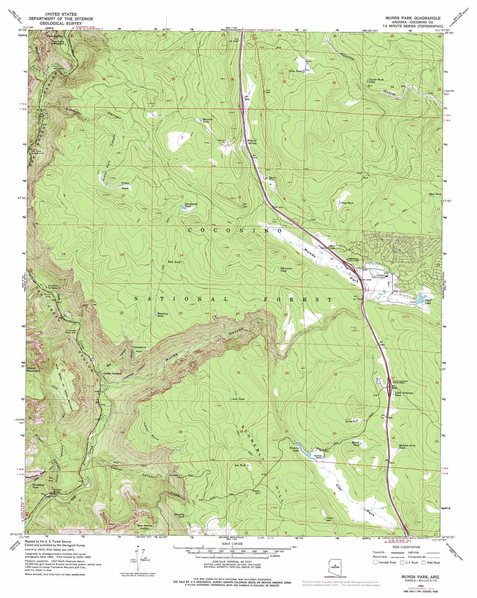
USGS Topo Quad 34111h6 - 1:24,000 scale
| Topo Map Name: | Munds Park |
| USGS Topo Quad ID: | 34111h6 |
| Print Size: | ca. 21 1/4" wide x 27" high |
| Southeast Coordinates: | 34.875° N latitude / 111.625° W longitude |
| Map Center Coordinates: | 34.9375° N latitude / 111.6875° W longitude |
| U.S. State: | AZ |
| Filename: | o34111h6.jpg |
| Download Map JPG Image: | Munds Park topo map 1:24,000 scale |
| Map Type: | Topographic |
| Topo Series: | 7.5´ |
| Map Scale: | 1:24,000 |
| Source of Map Images: | United States Geological Survey (USGS) |
| Alternate Map Versions: |
Munds Park AZ 1965, updated 1968 Download PDF Buy paper map Munds Park AZ 1965, updated 1974 Download PDF Buy paper map Munds Park AZ 1965, updated 1977 Download PDF Buy paper map Munds Park AZ 1965, updated 1977 Download PDF Buy paper map Munds Park AZ 2011 Download PDF Buy paper map Munds Park AZ 2014 Download PDF Buy paper map |
| FStopo: | US Forest Service topo Munds Park is available: Download FStopo PDF Download FStopo TIF |
1:24,000 Topo Quads surrounding Munds Park
Garland Prairie |
Bellemont |
Flagstaff West |
Flagstaff East |
Winona |
Sycamore Point |
Dutton Hill |
Mountainaire |
Lower Lake Mary |
Ashurst Lake |
Loy Butte |
Wilson Mountain |
Munds Park |
Mormon Mountain |
Mormon Lake |
Page Springs |
Sedona |
Munds Mountain |
Stoneman Lake |
Hutch Mountain |
Cornville |
Lake Montezuma |
Casner Butte |
Apache Maid Mountain |
Happy Jack |
> Back to 34111e1 at 1:100,000 scale
> Back to 34110a1 at 1:250,000 scale
> Back to U.S. Topo Maps home
Munds Park topo map: Gazetteer
Munds Park: Areas
Grasshopper Point elevation 1344m 4409′Munds Park: Bridges
Midgley Bridge elevation 1327m 4353′Munds Park: Cliffs
Indian Point elevation 1840m 6036′Thompsons Point elevation 1828m 5997′
Munds Park: Crossings
Little Antelope Interchange elevation 1976m 6482′Munds Park Interchange elevation 1971m 6466′
Willard Springs Interchange elevation 2038m 6686′
Munds Park: Dams
Foxboro Lake Dam elevation 1920m 6299′Odell Dam elevation 1971m 6466′
Munds Park: Flats
Clay Park elevation 1924m 6312′Crazy Park elevation 1983m 6505′
Munds Park elevation 1965m 6446′
Munds Park: Parks
Encinoso Picnic Area elevation 1450m 4757′Midgely Bridge Picnic Area elevation 1340m 4396′
Munds Park: Populated Places
Indian Gardens elevation 1403m 4603′Munds Park elevation 2012m 6601′
Munds Park: Reservoirs
Arts Tank elevation 1911m 6269′Beacon Tank elevation 1987m 6519′
Blowout Tank elevation 2049m 6722′
Camp Tank elevation 1981m 6499′
Canyon Tank elevation 2026m 6646′
Clay Tank elevation 1954m 6410′
Coyote Park Tank elevation 2098m 6883′
Coyote Tank elevation 2078m 6817′
Crazy Park Tank elevation 1979m 6492′
Deadwood Tank elevation 1994m 6541′
Fenceline Tank elevation 2018m 6620′
Fern Tank elevation 2116m 6942′
Fixup Tank elevation 1998m 6555′
Fox Tank elevation 2000m 6561′
Foxboro Lake elevation 1920m 6299′
Frog Tank elevation 2006m 6581′
Geronimo Number Two Tank elevation 1963m 6440′
Geronimo Tank elevation 2011m 6597′
Hope Tank elevation 1994m 6541′
Lee Tank elevation 1963m 6440′
Little Antelope Tank elevation 1958m 6423′
Mason Tank elevation 1948m 6391′
Mud Tank elevation 2061m 6761′
Munds Tank elevation 1972m 6469′
Odell Lake elevation 1971m 6466′
Powerline Tank elevation 1982m 6502′
Rock Tank elevation 1963m 6440′
Rocky Tank elevation 1986m 6515′
Roundup Tank elevation 1902m 6240′
Schnebly Number Two Tank elevation 1888m 6194′
Schnebly Tank elevation 1866m 6122′
Section Sixteen Tank elevation 1927m 6322′
Skeleton Park Tank elevation 1958m 6423′
Steamboat Tank elevation 1434m 4704′
Stuck Tank elevation 1985m 6512′
Super Tank elevation 2001m 6564′
Telephone Tank elevation 1993m 6538′
Thomas Point Tank elevation 1927m 6322′
Willard Mountain Tank elevation 2013m 6604′
Munds Park: Springs
Cave Spring elevation 1668m 5472′Willard Spring elevation 2056m 6745′
Munds Park: Streams
Hoels Wash elevation 1625m 5331′West Fork Oak Creek elevation 1610m 5282′
Munds Park: Summits
First Bench of Wilson Mountain elevation 1900m 6233′Schnebly Hill elevation 2026m 6646′
Wilson Mountain elevation 2137m 7011′
Munds Park: Trails
A B Young Trail elevation 1578m 5177′Casner Canyon Eleven Trail elevation 1486m 4875′
Thompson Ladder elevation 1531m 5022′
Thompsons Ladder Fourteen elevation 1590m 5216′
Wilson Mountain Trail elevation 1565m 5134′
Munds Park: Valleys
Bee Canyon elevation 1426m 4678′Casner Canyon elevation 1362m 4468′
Crazy Park Canyon elevation 1901m 6236′
Munds Canyon elevation 1403m 4603′
Oak Creek Canyon elevation 1397m 4583′
Surveyor Canyon elevation 1608m 5275′
Wilson Canyon elevation 1327m 4353′
Munds Park digital topo map on disk
Buy this Munds Park topo map showing relief, roads, GPS coordinates and other geographical features, as a high-resolution digital map file on DVD: