Flores Topo Map Arizona
To zoom in, hover over the map of Flores
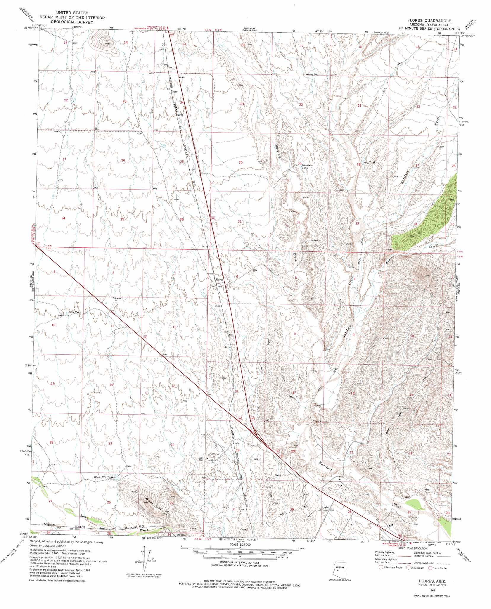
USGS Topo Quad 34112a7 - 1:24,000 scale
| Topo Map Name: | Flores |
| USGS Topo Quad ID: | 34112a7 |
| Print Size: | ca. 21 1/4" wide x 27" high |
| Southeast Coordinates: | 34° N latitude / 112.75° W longitude |
| Map Center Coordinates: | 34.0625° N latitude / 112.8125° W longitude |
| U.S. State: | AZ |
| Filename: | o34112a7.jpg |
| Download Map JPG Image: | Flores topo map 1:24,000 scale |
| Map Type: | Topographic |
| Topo Series: | 7.5´ |
| Map Scale: | 1:24,000 |
| Source of Map Images: | United States Geological Survey (USGS) |
| Alternate Map Versions: |
Flores AZ 1969, updated 1972 Download PDF Buy paper map Flores AZ 1969, updated 1980 Download PDF Buy paper map Flores AZ 1969, updated 1980 Download PDF Buy paper map Flores AZ 2011 Download PDF Buy paper map Flores AZ 2014 Download PDF Buy paper map |
1:24,000 Topo Quads surrounding Flores
Malpais Mesa |
Date |
Weaver Peak |
Peeples Valley |
Walnut Grove |
Date Creek Ranch |
O'Neill Pass |
Congress |
Yarnell |
Wagoner |
Date Creek Ranch Se |
Congress Sw |
Flores |
Sam Powell Peak |
Morgan Butte |
Forepaugh Peak |
Outlaw Hill |
Vulture Peak |
Wickenburg |
Red Picacho |
Black Butte |
Wildcat Well |
Vulture Mine |
Wickenburg Sw |
Wittmann |
> Back to 34112a1 at 1:100,000 scale
> Back to 34112a1 at 1:250,000 scale
> Back to U.S. Topo Maps home
Flores topo map: Gazetteer
Flores: Airports
Moreton Airport elevation 744m 2440′Flores: Populated Places
Flores elevation 793m 2601′Flores: Reservoirs
Big Tank elevation 812m 2664′Black Hill Tank elevation 741m 2431′
Martinez Tank elevation 813m 2667′
Pitts Tank elevation 790m 2591′
Flores: Streams
Antelope Creek elevation 715m 2345′Martinez Creek elevation 714m 2342′
Weaver Creek elevation 743m 2437′
Flores: Summits
Black Hill elevation 842m 2762′Flores digital topo map on disk
Buy this Flores topo map showing relief, roads, GPS coordinates and other geographical features, as a high-resolution digital map file on DVD: