Congress Topo Map Arizona
To zoom in, hover over the map of Congress
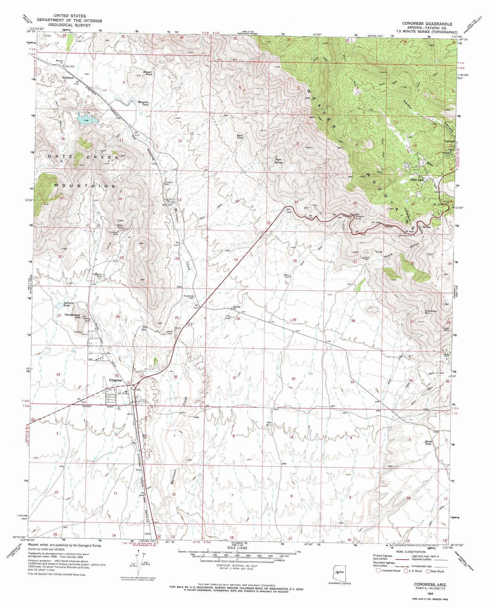
USGS Topo Quad 34112b7 - 1:24,000 scale
| Topo Map Name: | Congress |
| USGS Topo Quad ID: | 34112b7 |
| Print Size: | ca. 21 1/4" wide x 27" high |
| Southeast Coordinates: | 34.125° N latitude / 112.75° W longitude |
| Map Center Coordinates: | 34.1875° N latitude / 112.8125° W longitude |
| U.S. State: | AZ |
| Filename: | o34112b7.jpg |
| Download Map JPG Image: | Congress topo map 1:24,000 scale |
| Map Type: | Topographic |
| Topo Series: | 7.5´ |
| Map Scale: | 1:24,000 |
| Source of Map Images: | United States Geological Survey (USGS) |
| Alternate Map Versions: |
Congress AZ 1969, updated 1973 Download PDF Buy paper map Congress AZ 1969, updated 1973 Download PDF Buy paper map Congress AZ 1969, updated 1973 Download PDF Buy paper map Congress AZ 2011 Download PDF Buy paper map Congress AZ 2014 Download PDF Buy paper map |
1:24,000 Topo Quads surrounding Congress
Malpais Mesa Ne |
Hillside |
Bismarck Mesa |
Kirkland |
Wilhoit |
Malpais Mesa |
Date |
Weaver Peak |
Peeples Valley |
Walnut Grove |
Date Creek Ranch |
O'Neill Pass |
Congress |
Yarnell |
Wagoner |
Date Creek Ranch Se |
Congress Sw |
Flores |
Sam Powell Peak |
Morgan Butte |
Forepaugh Peak |
Outlaw Hill |
Vulture Peak |
Wickenburg |
Red Picacho |
> Back to 34112a1 at 1:100,000 scale
> Back to 34112a1 at 1:250,000 scale
> Back to U.S. Topo Maps home
Congress topo map: Gazetteer
Congress: Bends
Elephant Curve elevation 1222m 4009′View Points elevation 1348m 4422′
Congress: Dams
Billingsley Number Four Dam elevation 1011m 3316′Billingsley Number Three Dam elevation 1038m 3405′
Billingsley Number Two Dam elevation 1025m 3362′
Congress: Mines
Blue Bucket Mine elevation 1191m 3907′Congress Mine elevation 1035m 3395′
Planet Saturn Mine elevation 1113m 3651′
Rincon Mine elevation 1211m 3973′
Senate Mine elevation 1017m 3336′
Congress: Parks
Tenderfoot Hill Park elevation 961m 3152′Congress: Populated Places
Congress elevation 930m 3051′Congress Junction elevation 927m 3041′
Glen Ilah elevation 1474m 4835′
Piedmont elevation 1018m 3339′
Congress: Post Offices
Congress Post Office elevation 929m 3047′Congress: Ranges
Weaver Mountains elevation 1649m 5410′Congress: Reservoirs
Billingsley Reservoir Number Four elevation 1011m 3316′Billingsley Reservoir Number Three elevation 1038m 3405′
Billingsley Reservoir Number Two elevation 1025m 3362′
Earis Tank elevation 970m 3182′
Mesquite Tank elevation 1015m 3330′
Sawyer Tank elevation 0m 0′
Sullivan Tank elevation 958m 3143′
Ziger Tank elevation 1150m 3772′
Congress: Springs
Ziger Spring elevation 1215m 3986′Congress: Summits
Tenderfoot Hill elevation 1053m 3454′Congress: Valleys
Cottonwood Canyon elevation 1347m 4419′Fools Gulch elevation 1037m 3402′
Congress: Wells
Arrowhead Well elevation 943m 3093′Longort Well elevation 977m 3205′
Lowman Well elevation 973m 3192′
Congress digital topo map on disk
Buy this Congress topo map showing relief, roads, GPS coordinates and other geographical features, as a high-resolution digital map file on DVD: