O'Neill Pass Topo Map Arizona
To zoom in, hover over the map of O'Neill Pass
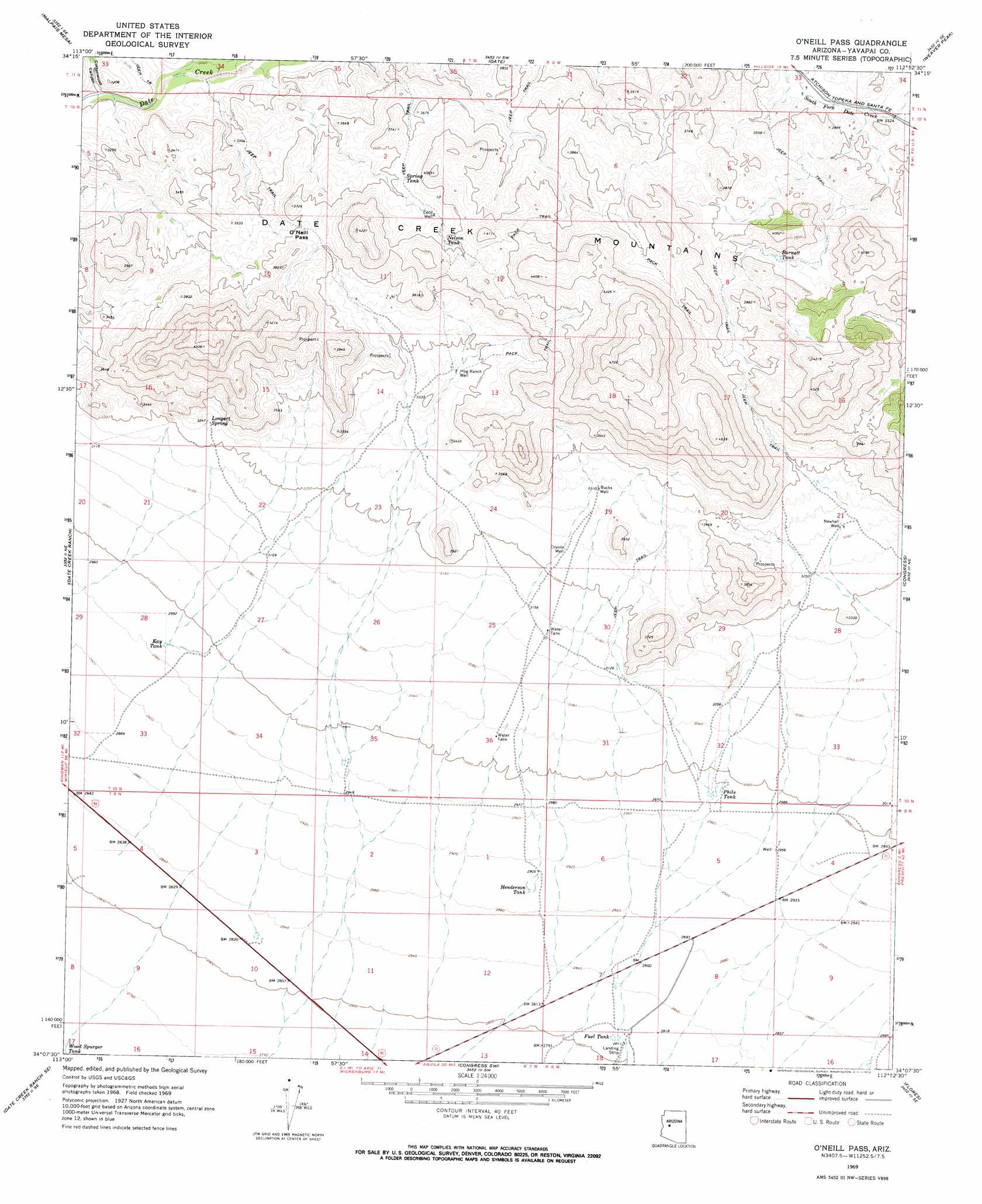
USGS Topo Quad 34112b8 - 1:24,000 scale
| Topo Map Name: | O'Neill Pass |
| USGS Topo Quad ID: | 34112b8 |
| Print Size: | ca. 21 1/4" wide x 27" high |
| Southeast Coordinates: | 34.125° N latitude / 112.875° W longitude |
| Map Center Coordinates: | 34.1875° N latitude / 112.9375° W longitude |
| U.S. State: | AZ |
| Filename: | o34112b8.jpg |
| Download Map JPG Image: | O'Neill Pass topo map 1:24,000 scale |
| Map Type: | Topographic |
| Topo Series: | 7.5´ |
| Map Scale: | 1:24,000 |
| Source of Map Images: | United States Geological Survey (USGS) |
| Alternate Map Versions: |
O'Neill Pass AZ 1969, updated 1972 Download PDF Buy paper map O'Neill Pass AZ 2011 Download PDF Buy paper map O'Neill Pass AZ 2014 Download PDF Buy paper map |
1:24,000 Topo Quads surrounding O'Neill Pass
Thorn Peak |
Malpais Mesa Ne |
Hillside |
Bismarck Mesa |
Kirkland |
Ives Peak |
Malpais Mesa |
Date |
Weaver Peak |
Peeples Valley |
Date Creek Ranch Nw |
Date Creek Ranch |
O'Neill Pass |
Congress |
Yarnell |
Date Creek Ranch Sw |
Date Creek Ranch Se |
Congress Sw |
Flores |
Sam Powell Peak |
Aguila |
Forepaugh Peak |
Outlaw Hill |
Vulture Peak |
Wickenburg |
> Back to 34112a1 at 1:100,000 scale
> Back to 34112a1 at 1:250,000 scale
> Back to U.S. Topo Maps home
O'Neill Pass topo map: Gazetteer
O'Neill Pass: Gaps
O'Neil Pass elevation 1112m 3648′O'Neill Pass: Ranges
Date Creek Mountains elevation 1206m 3956′O'Neill Pass: Reservoirs
Barnett Tank elevation 1085m 3559′Fuel Tank elevation 858m 2814′
Henderson Tank elevation 884m 2900′
Kay Tank elevation 907m 2975′
Nelson Tank elevation 1146m 3759′
Phils Tank elevation 911m 2988′
Spring Tank elevation 1104m 3622′
O'Neill Pass: Springs
Longort Spring elevation 996m 3267′O'Neill Pass: Streams
Martin Creek elevation 1224m 4015′O'Neill Pass: Valleys
Cottonwood Canyon elevation 915m 3001′O'Neill Pass: Wells
Bucks Well elevation 1011m 3316′Cecil Well elevation 1125m 3690′
Coyote Well elevation 986m 3234′
Hog Ranch Well elevation 1022m 3353′
Newhall Well elevation 1004m 3293′
O'Neill Pass digital topo map on disk
Buy this O'Neill Pass topo map showing relief, roads, GPS coordinates and other geographical features, as a high-resolution digital map file on DVD: