Wilhoit Topo Map Arizona
To zoom in, hover over the map of Wilhoit
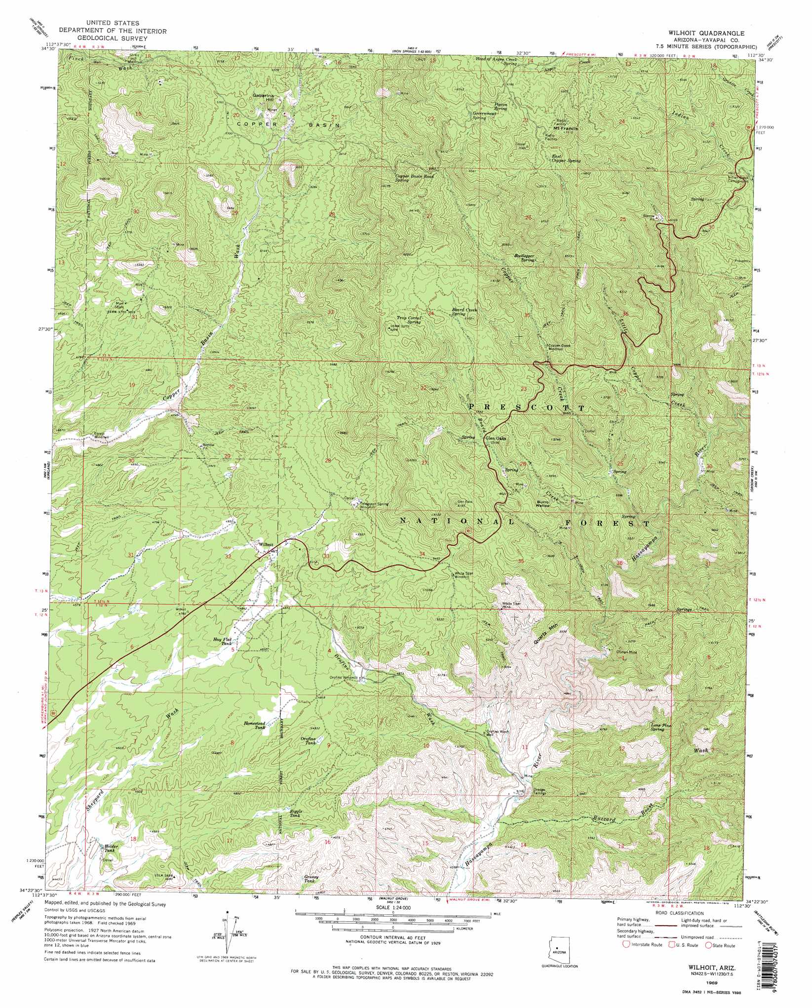
USGS Topo Quad 34112d5 - 1:24,000 scale
| Topo Map Name: | Wilhoit |
| USGS Topo Quad ID: | 34112d5 |
| Print Size: | ca. 21 1/4" wide x 27" high |
| Southeast Coordinates: | 34.375° N latitude / 112.5° W longitude |
| Map Center Coordinates: | 34.4375° N latitude / 112.5625° W longitude |
| U.S. State: | AZ |
| Filename: | o34112d5.jpg |
| Download Map JPG Image: | Wilhoit topo map 1:24,000 scale |
| Map Type: | Topographic |
| Topo Series: | 7.5´ |
| Map Scale: | 1:24,000 |
| Source of Map Images: | United States Geological Survey (USGS) |
| Alternate Map Versions: |
Wilhoit AZ 1969, updated 1979 Download PDF Buy paper map Wilhoit AZ 1969, updated 1979 Download PDF Buy paper map Wilhoit AZ 2012 Download PDF Buy paper map Wilhoit AZ 2014 Download PDF Buy paper map |
| FStopo: | US Forest Service topo Wilhoit is available: Download FStopo PDF Download FStopo TIF |
1:24,000 Topo Quads surrounding Wilhoit
Smith Mesa |
Mount Josh |
Jerome Canyon |
Chino Valley South |
Prescott Valley North |
Martin Mountain |
Skull Valley |
Iron Springs |
Prescott |
Prescott Valley South |
Bismarck Mesa |
Kirkland |
Wilhoit |
Groom Creek |
Poland Junction |
Weaver Peak |
Peeples Valley |
Walnut Grove |
Battleship Butte |
Battle Flat |
Congress |
Yarnell |
Wagoner |
Minnehaha |
Crown King |
> Back to 34112a1 at 1:100,000 scale
> Back to 34112a1 at 1:250,000 scale
> Back to U.S. Topo Maps home
Wilhoit topo map: Gazetteer
Wilhoit: Basins
Burro Wallow elevation 1628m 5341′Copper Basin elevation 1597m 5239′
Wilhoit: Canals
McNary Siphon elevation 1576m 5170′Wilhoit: Mines
Climax Mine elevation 1445m 4740′Continental Mine elevation 1626m 5334′
Mint Shaft elevation 1529m 5016′
Oro Flame Mine elevation 1635m 5364′
White Spar Mine elevation 1634m 5360′
Wilhoit: Populated Places
Glen Oaks elevation 1675m 5495′Wilhoit elevation 1533m 5029′
Wilhoit: Reservoirs
Grassy Tank elevation 1433m 4701′Hay Flat Tank elevation 1452m 4763′
Holder Tank elevation 1340m 4396′
Homestead Tank elevation 1444m 4737′
Orofino Tank elevation 1474m 4835′
Riggle Tank elevation 1423m 4668′
Wilhoit Tank elevation 1519m 4983′
Wilhoit: Springs
Board Creek Spring elevation 1806m 5925′Bootlegger Spring elevation 1781m 5843′
Buzzard Spring elevation 1299m 4261′
Canfield Spring elevation 1869m 6131′
Copper Basin Road Spring elevation 1770m 5807′
East Copper Spring elevation 2059m 6755′
Glen Oaks Spring elevation 1697m 5567′
Government Spring elevation 1975m 6479′
Head of Aspen Creek Spring elevation 2037m 6683′
Lee Spring elevation 1460m 4790′
Lone Pine Spring elevation 1523m 4996′
Pigeon Spring elevation 2057m 6748′
Telegraph Spring elevation 1644m 5393′
Trap Corral Spring elevation 1815m 5954′
White Rock Water elevation 1693m 5554′
White Rock Water elevation 1736m 5695′
Wilhoit Spring elevation 1530m 5019′
Wilhoit: Streams
Board Creek elevation 1458m 4783′Buzzard Roost Wash elevation 1256m 4120′
Copper Creek elevation 1498m 4914′
Little Copper Creek elevation 1543m 5062′
Orofino Wash elevation 1270m 4166′
Wilhoit: Summits
Gabarina Hill elevation 1688m 5538′Mount Francis elevation 2161m 7089′
Quartz Mountain elevation 1698m 5570′
Top of Pines elevation 1802m 5912′
Wilhoit: Trails
Mount Francis Trail Forty Eight elevation 1990m 6528′Wilhoit: Wells
Orofino Wash Well elevation 1331m 4366′Wilhoit digital topo map on disk
Buy this Wilhoit topo map showing relief, roads, GPS coordinates and other geographical features, as a high-resolution digital map file on DVD: