Prescott Topo Map Arizona
To zoom in, hover over the map of Prescott
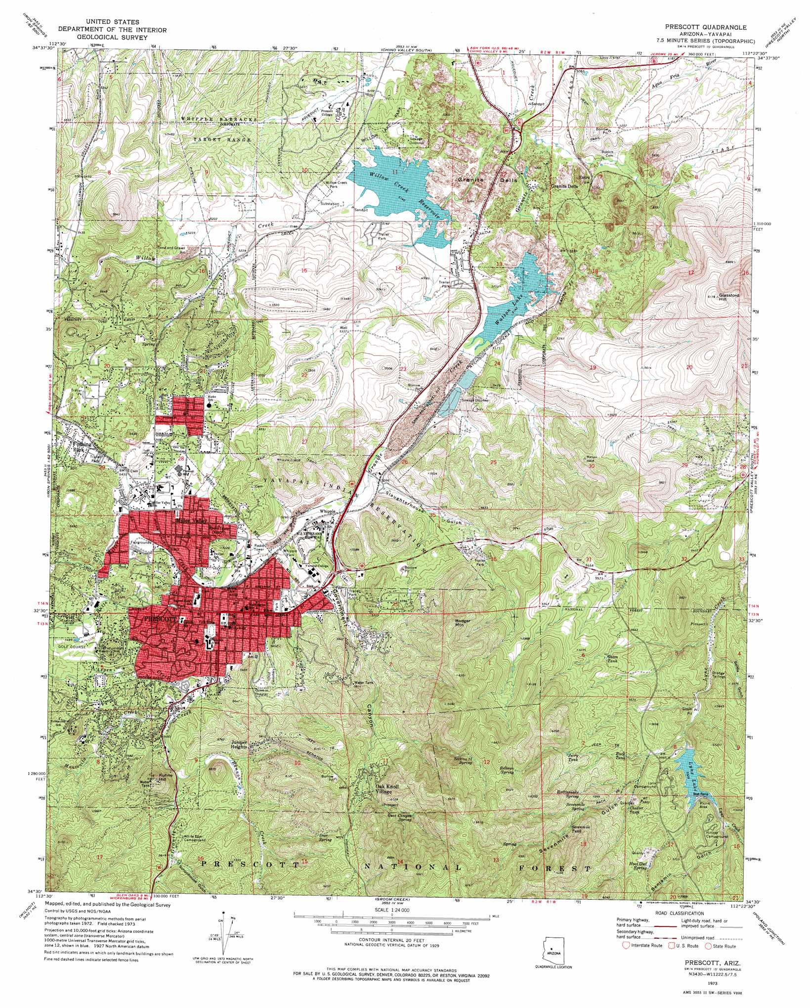
USGS Topo Quad 34112e4 - 1:24,000 scale
| Topo Map Name: | Prescott |
| USGS Topo Quad ID: | 34112e4 |
| Print Size: | ca. 21 1/4" wide x 27" high |
| Southeast Coordinates: | 34.5° N latitude / 112.375° W longitude |
| Map Center Coordinates: | 34.5625° N latitude / 112.4375° W longitude |
| U.S. State: | AZ |
| Filename: | o34112e4.jpg |
| Download Map JPG Image: | Prescott topo map 1:24,000 scale |
| Map Type: | Topographic |
| Topo Series: | 7.5´ |
| Map Scale: | 1:24,000 |
| Source of Map Images: | United States Geological Survey (USGS) |
| Alternate Map Versions: |
Prescott AZ 1973, updated 1977 Download PDF Buy paper map Prescott AZ 1973, updated 1977 Download PDF Buy paper map Prescott AZ 2012 Download PDF Buy paper map Prescott AZ 2014 Download PDF Buy paper map |
| FStopo: | US Forest Service topo Prescott is available: Download FStopo PDF Download FStopo TIF |
1:24,000 Topo Quads surrounding Prescott
Simmons |
Sullivan Buttes |
Chino Valley North |
King Canyon |
Munds Draw |
Mount Josh |
Jerome Canyon |
Chino Valley South |
Prescott Valley North |
Hickey Mountain |
Skull Valley |
Iron Springs |
Prescott |
Prescott Valley South |
Humboldt |
Kirkland |
Wilhoit |
Groom Creek |
Poland Junction |
Mayer |
Peeples Valley |
Walnut Grove |
Battleship Butte |
Battle Flat |
Cleator |
> Back to 34112e1 at 1:100,000 scale
> Back to 34112a1 at 1:250,000 scale
> Back to U.S. Topo Maps home
Prescott topo map: Gazetteer
Prescott: Crossings
Granite Creek Overpass elevation 1610m 5282′Prescott: Dams
Granite Creek Dam elevation 1574m 5164′Lynx Lake Dam elevation 1692m 5551′
Willow Creek Dam elevation 1568m 5144′
Prescott: Parks
Acker Park elevation 1658m 5439′Badger Park elevation 1636m 5367′
Granite Creek Park elevation 1615m 5298′
Heritage Park elevation 1576m 5170′
Honor Island Park elevation 1637m 5370′
Jefferson Park elevation 1651m 5416′
Ken Lindley Park elevation 1644m 5393′
Roughrider Park elevation 1624m 5328′
Watson Lake Park elevation 1601m 5252′
Whipple Park elevation 1619m 5311′
Willow Creek Park elevation 1572m 5157′
Willow Lake Park elevation 1576m 5170′
Yavapai County Fairgrounds elevation 1644m 5393′
Prescott: Populated Places
Diamond Valley elevation 1598m 5242′Entro elevation 1567m 5141′
Forbing Park elevation 1672m 5485′
Fort Whipple elevation 1618m 5308′
Granite Dells elevation 1551m 5088′
Juniper Heights elevation 1757m 5764′
Miller Valley elevation 1636m 5367′
Oak Knoll Village elevation 1787m 5862′
P and E Junction elevation 1564m 5131′
Prescott elevation 1638m 5374′
Whipple elevation 1605m 5265′
Yavapai Hills elevation 1632m 5354′
Prescott: Post Offices
Miller Valley Post Office elevation 1635m 5364′Prescott Post Office elevation 1635m 5364′
Prescott: Reservoirs
Buck Tank elevation 1715m 5626′Chester Tank elevation 1728m 5669′
Gates Tank elevation 1713m 5620′
Jerry Tank elevation 1778m 5833′
Lynx Lake elevation 1692m 5551′
Sevenmile Tank elevation 1801m 5908′
Watson Lake elevation 1559m 5114′
Willow Creek Reservoir elevation 1567m 5141′
Prescott: Springs
Bellows Spring elevation 1880m 6167′Deer Spring elevation 1818m 5964′
Government Canyon Spring elevation 1871m 6138′
Hoot Owl Spring elevation 1749m 5738′
Rattlesnake Spring elevation 1776m 5826′
Section Twelve Spring elevation 1886m 6187′
Sevenmile Spring elevation 1769m 5803′
Prescott: Streams
Aspen Creek elevation 1635m 5364′Banning Creek elevation 1680m 5511′
Butte Creek elevation 1624m 5328′
Manzanita Creek elevation 1653m 5423′
Miller Creek elevation 1619m 5311′
Willow Creek elevation 1568m 5144′
Prescott: Summits
Badger Mountain elevation 1904m 6246′Glassford Hill elevation 1880m 6167′
Indian Hill elevation 1728m 5669′
Kuhne Hill elevation 1804m 5918′
Prescott: Valleys
Benjamin Gulch elevation 1692m 5551′Government Canyon elevation 1597m 5239′
Granite Dells elevation 1526m 5006′
Salida Gulch elevation 1640m 5380′
Schoolhouse Gulch elevation 1718m 5636′
Sevenmile Gulch elevation 1671m 5482′
Slaughterhouse Gulch elevation 1594m 5229′
Prescott digital topo map on disk
Buy this Prescott topo map showing relief, roads, GPS coordinates and other geographical features, as a high-resolution digital map file on DVD: