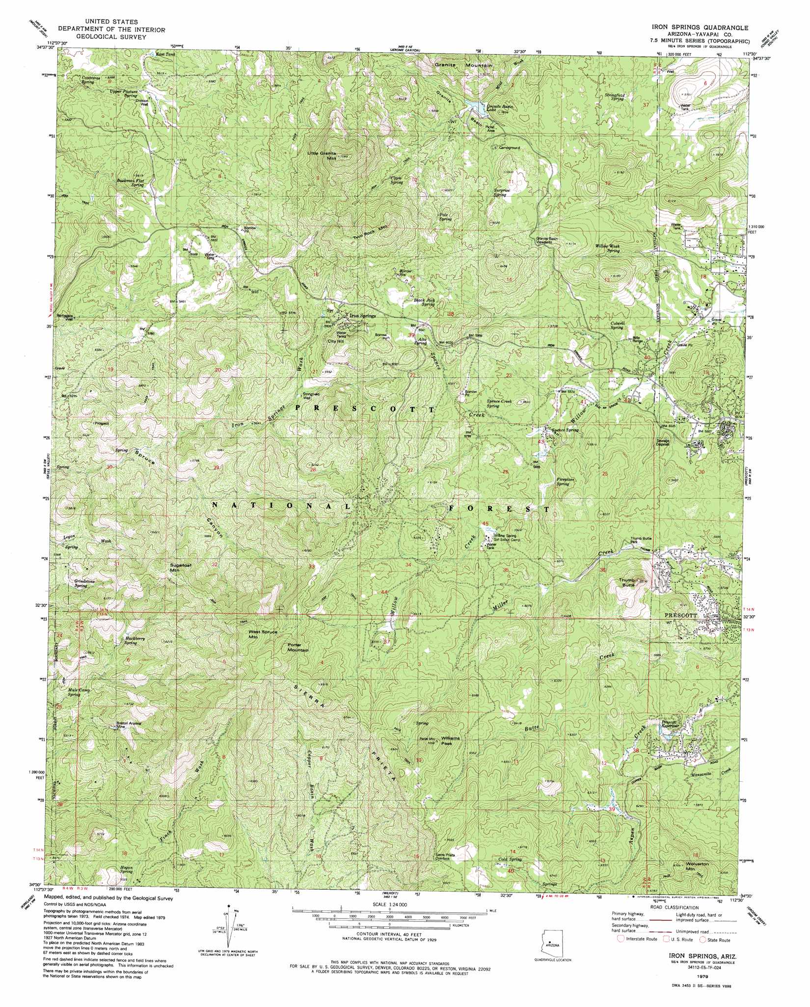
Iron Springs Topo Map Arizona
To zoom in, hover over the map of Iron Springs
USGS Topo Quad 34112e5 - 1:24,000 scale
| Topo Map Name: | Iron Springs |
| USGS Topo Quad ID: | 34112e5 |
| Print Size: | ca. 21 1/4" wide x 27" high |
| Southeast Coordinates: | 34.5° N latitude / 112.5° W longitude |
| Map Center Coordinates: | 34.5625° N latitude / 112.5625° W longitude |
| U.S. State: | AZ |
| Filename: | o34112e5.jpg |
| Download Map JPG Image: | Iron Springs topo map 1:24,000 scale |
| Map Type: | Topographic |
| Topo Series: | 7.5´ |
| Map Scale: | 1:24,000 |
| Source of Map Images: | United States Geological Survey (USGS) |
| Alternate Map Versions: |
Iron Springs AZ 1979, updated 1980 Download PDF Buy paper map Iron Springs AZ 1979, updated 1985 Download PDF Buy paper map Iron Springs AZ 1979, updated 1985 Download PDF Buy paper map Iron Springs AZ 2012 Download PDF Buy paper map Iron Springs AZ 2014 Download PDF Buy paper map |
| FStopo: | US Forest Service topo Iron Springs is available: Download FStopo PDF Download FStopo TIF |
1:24,000 Topo Quads surrounding Iron Springs
Seepage Mountain |
Simmons |
Sullivan Buttes |
Chino Valley North |
King Canyon |
Smith Mesa |
Mount Josh |
Jerome Canyon |
Chino Valley South |
Prescott Valley North |
Martin Mountain |
Skull Valley |
Iron Springs |
Prescott |
Prescott Valley South |
Bismarck Mesa |
Kirkland |
Wilhoit |
Groom Creek |
Poland Junction |
Weaver Peak |
Peeples Valley |
Walnut Grove |
Battleship Butte |
Battle Flat |
> Back to 34112e1 at 1:100,000 scale
> Back to 34112a1 at 1:250,000 scale
> Back to U.S. Topo Maps home
Iron Springs topo map: Gazetteer
Iron Springs: Areas
Granite Basin Viewpoint elevation 1831m 6007′Iron Springs: Basins
Granite Basin elevation 1712m 5616′Iron Springs: Dams
Granite Basin Dam elevation 1745m 5725′Iron Springs: Forests
Prescott National Forest elevation 1695m 5561′Iron Springs: Lakes
Lon Stringfield elevation 1656m 5433′Iron Springs: Mines
Alto Borrow Pits elevation 1879m 6164′Boston Arizona Mine elevation 1650m 5413′
Derby Mine elevation 1944m 6377′
Iron Springs: Parks
Granite Basin Picnic Area elevation 1709m 5606′Thumb Butte Park elevation 1738m 5702′
Iron Springs: Populated Places
Deering Park Estates elevation 1903m 6243′Granite Basin Summer Homes elevation 1728m 5669′
Highland Park elevation 1954m 6410′
Highland Pines elevation 1958m 6423′
Iron Springs elevation 1851m 6072′
Rancho Vista Estates elevation 1767m 5797′
Wildwood Estates elevation 1699m 5574′
Iron Springs: Post Offices
Iron Springs Post Office elevation 1822m 5977′Iron Springs: Ranges
Sierra Prieta elevation 1941m 6368′Iron Springs: Reservoirs
Contreras Trick Tank elevation 1715m 5626′Doce Tank elevation 1706m 5597′
East Tank elevation 1642m 5387′
Granite Basin Lake elevation 1697m 5567′
Juniper Tank elevation 1870m 6135′
Prescott Reservoir elevation 1765m 5790′
Track Tank elevation 1729m 5672′
Iron Springs: Springs
Alto Spring elevation 1823m 5980′Aspen Creek Spring elevation 1937m 6354′
Aspen Spring elevation 2015m 6610′
Backman Flat Spring elevation 1640m 5380′
Black Jack Spring elevation 1819m 5967′
Buckman Flat Spring elevation 1640m 5380′
Buttes Spring elevation 1615m 5298′
Buttes Spring elevation 1584m 5196′
Clark Spring elevation 1851m 6072′
Cold Spring elevation 2028m 6653′
Contreras Spring elevation 1577m 5173′
Cowell Spring elevation 1692m 5551′
Deep Spring elevation 1724m 5656′
Deep Spring elevation 1732m 5682′
Finch Spring elevation 1741m 5711′
Fireplace Spring elevation 1718m 5636′
Grindstone Spring elevation 1680m 5511′
Hackberry Spring elevation 1707m 5600′
Hogan Spring elevation 1621m 5318′
Iron Springs elevation 1573m 5160′
Mule Camp Spring elevation 1603m 5259′
Pole Spring elevation 1830m 6003′
Porter Spring elevation 1927m 6322′
Ramsgate Spring elevation 1574m 5164′
Spence Creek Spring elevation 1745m 5725′
Spence Spring elevation 1705m 5593′
Spruce Canyon Spring elevation 1707m 5600′
Spruce Creek Spring elevation 1747m 5731′
Stringfield Spring elevation 1736m 5695′
Surprise Spring elevation 1755m 5757′
Upper Basin Spring elevation 1833m 6013′
Upper Pasture Spring elevation 1622m 5321′
Willow Wash Spring elevation 1727m 5666′
Iron Springs: Streams
Iron Springs Wash elevation 1865m 6118′Spence Creek elevation 1695m 5561′
Iron Springs: Summits
City Hill elevation 1925m 6315′Little Granite Mountain elevation 2160m 7086′
Porter Mountain elevation 2151m 7057′
Prietal elevation 1906m 6253′
Sugarloaf Mountain elevation 1993m 6538′
Thumb Butte elevation 1979m 6492′
Two Rock Mountain elevation 2101m 6893′
West Spruce Mountain elevation 2185m 7168′
Williams Peak elevation 2108m 6916′
Wolverton Mountain elevation 2038m 6686′
Iron Springs: Trails
Granite Mountain Trail Number Two Hundred Sixty One elevation 1751m 5744′Little Granite Mountain Trail Number Thiry Seven elevation 1817m 5961′
Sierra Prieta Crest Trail Nmber Two Hundred Sixty Four elevation 2020m 6627′
White Rock Spring Loop Trail Number Thirty Eight elevation 1671m 5482′
Iron Springs: Wells
Division Well elevation 1635m 5364′Ramsgate Well elevation 1561m 5121′
Stringfield Well elevation 1738m 5702′
Iron Springs digital topo map on disk
Buy this Iron Springs topo map showing relief, roads, GPS coordinates and other geographical features, as a high-resolution digital map file on DVD: