Martin Mountain Topo Map Arizona
To zoom in, hover over the map of Martin Mountain
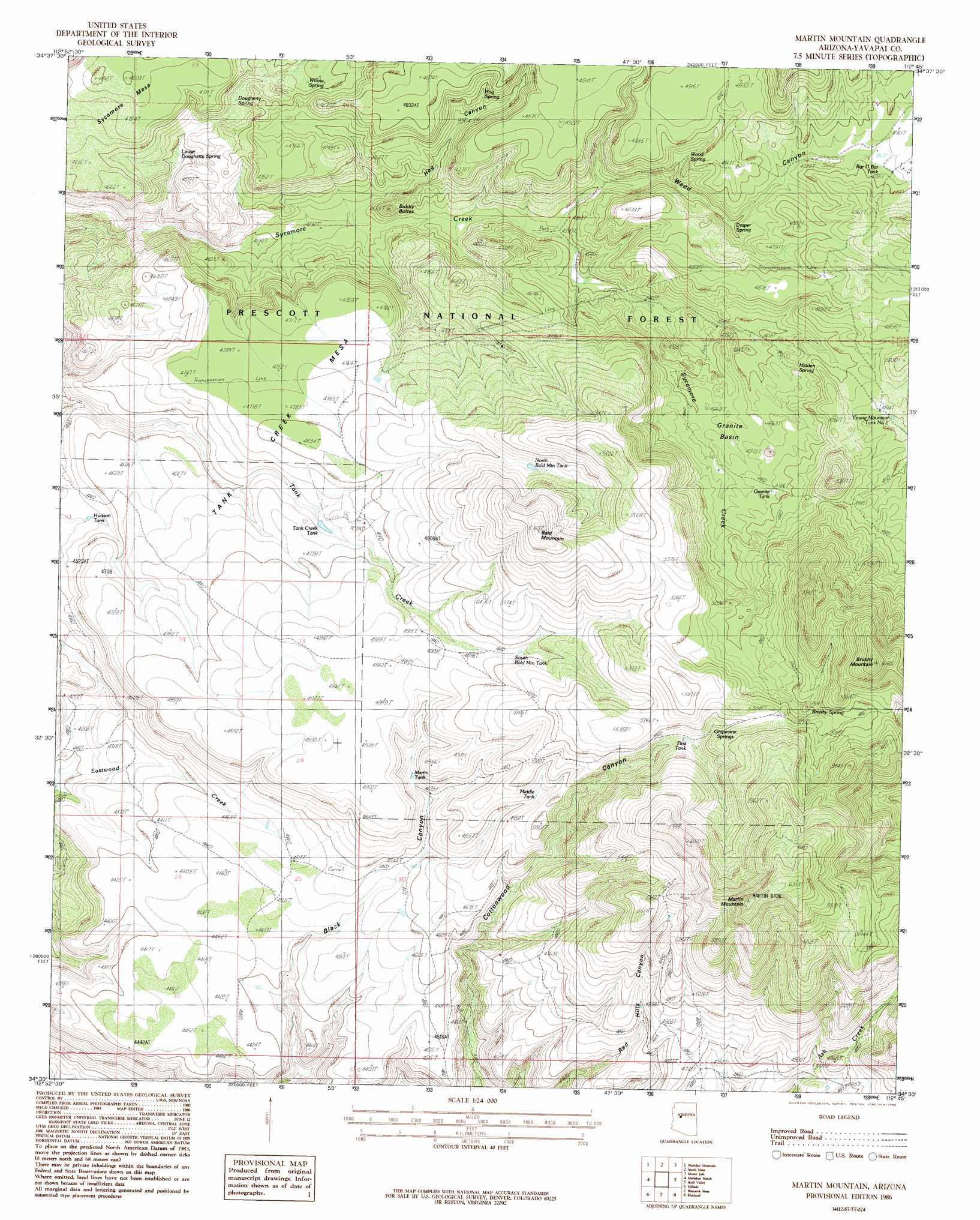
USGS Topo Quad 34112e7 - 1:24,000 scale
| Topo Map Name: | Martin Mountain |
| USGS Topo Quad ID: | 34112e7 |
| Print Size: | ca. 21 1/4" wide x 27" high |
| Southeast Coordinates: | 34.5° N latitude / 112.75° W longitude |
| Map Center Coordinates: | 34.5625° N latitude / 112.8125° W longitude |
| U.S. State: | AZ |
| Filename: | o34112e7.jpg |
| Download Map JPG Image: | Martin Mountain topo map 1:24,000 scale |
| Map Type: | Topographic |
| Topo Series: | 7.5´ |
| Map Scale: | 1:24,000 |
| Source of Map Images: | United States Geological Survey (USGS) |
| Alternate Map Versions: |
Martin Mountain AZ 1986, updated 1986 Download PDF Buy paper map Martin Mountain AZ 2012 Download PDF Buy paper map Martin Mountain AZ 2014 Download PDF Buy paper map |
| FStopo: | US Forest Service topo Martin Mountain is available: Download FStopo PDF Download FStopo TIF |
1:24,000 Topo Quads surrounding Martin Mountain
Scratch Canyon |
Camp Wood |
Seepage Mountain |
Simmons |
Sullivan Buttes |
Behm Mesa |
Sheridan Mountain |
Smith Mesa |
Mount Josh |
Jerome Canyon |
Big Shipp Mountain |
Muleshoe Ranch |
Martin Mountain |
Skull Valley |
Iron Springs |
Malpais Mesa Ne |
Hillside |
Bismarck Mesa |
Kirkland |
Wilhoit |
Malpais Mesa |
Date |
Weaver Peak |
Peeples Valley |
Walnut Grove |
> Back to 34112e1 at 1:100,000 scale
> Back to 34112a1 at 1:250,000 scale
> Back to U.S. Topo Maps home
Martin Mountain topo map: Gazetteer
Martin Mountain: Basins
Granite Basin elevation 1416m 4645′Martin Mountain: Populated Places
Wood Trap elevation 1348m 4422′Martin Mountain: Reservoirs
Bar U Bar Tank elevation 1448m 4750′Brushy Mountain Number 1 Tank elevation 1745m 5725′
Brushy Mountain Number 2 Tank elevation 1580m 5183′
Draper Spring elevation 1401m 4596′
First Tank elevation 1536m 5039′
Granite Tank elevation 1447m 4747′
Hudson Tank elevation 1372m 4501′
Martin Mountain Tank elevation 1420m 4658′
Middle Tank elevation 1471m 4826′
North Bald Mountain Tank elevation 1542m 5059′
South Bald Mountain Tank elevation 1522m 4993′
Stevens Tank elevation 1434m 4704′
Tank Creek Tank elevation 1431m 4694′
Tank Water Tank elevation 1392m 4566′
Young Mountain Number Two Tank elevation 1487m 4878′
Martin Mountain: Springs
Brushy Spring elevation 1595m 5232′Dougherty Spring elevation 1358m 4455′
Grapevine Springs elevation 1593m 5226′
Hidden Spring elevation 1435m 4708′
Hog Spring elevation 1368m 4488′
Lower Dougherty Spring elevation 1341m 4399′
Willow Spring elevation 1385m 4543′
Wood Spring elevation 1413m 4635′
Martin Mountain: Summits
Bald Mountain elevation 1750m 5741′Brushy Mountain elevation 1883m 6177′
Bubby Buttes elevation 1395m 4576′
Martin Mountain elevation 1960m 6430′
Tank Creek Mesa elevation 1404m 4606′
Martin Mountain: Valleys
Dougherty Canyon elevation 1289m 4229′Hog Canyon elevation 1303m 4274′
Weed Canyon elevation 1330m 4363′
Martin Mountain: Wells
Webb Windmill elevation 1420m 4658′Martin Mountain digital topo map on disk
Buy this Martin Mountain topo map showing relief, roads, GPS coordinates and other geographical features, as a high-resolution digital map file on DVD: