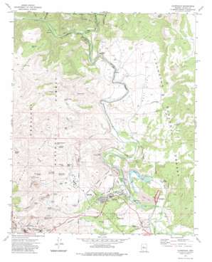
Clarkdale Topo Map Arizona
To zoom in, hover over the map of Clarkdale
USGS Topo Quad 34112g1 - 1:24,000 scale
| Topo Map Name: | Clarkdale |
| USGS Topo Quad ID: | 34112g1 |
| Print Size: | ca. 21 1/4" wide x 27" high |
| Southeast Coordinates: | 34.75° N latitude / 112° W longitude |
| Map Center Coordinates: | 34.8125° N latitude / 112.0625° W longitude |
| U.S. State: | AZ |
| Filename: | o34112g1.jpg |
| Download Map JPG Image: | Clarkdale topo map 1:24,000 scale |
| Map Type: | Topographic |
| Topo Series: | 7.5´ |
| Map Scale: | 1:24,000 |
| Source of Map Images: | United States Geological Survey (USGS) |
| Alternate Map Versions: |
Clarkdale AZ 1973, updated 1977 Download PDF Buy paper map Clarkdale AZ 1973, updated 1983 Download PDF Buy paper map Clarkdale AZ 1973, updated 1983 Download PDF Buy paper map Clarkdale AZ 2012 Download PDF Buy paper map Clarkdale AZ 2014 Download PDF Buy paper map |
| FStopo: | US Forest Service topo Clarkdale is available: Download FStopo PDF Download FStopo TIF |
1:24,000 Topo Quads surrounding Clarkdale
> Back to 34112e1 at 1:100,000 scale
> Back to 34112a1 at 1:250,000 scale
> Back to U.S. Topo Maps home
Clarkdale topo map: Gazetteer
Clarkdale: Flats
Duff Flat elevation 1113m 3651′Clarkdale: Mines
A and A Shaft elevation 1530m 5019′Dundee Shaft elevation 1420m 4658′
Texas Shaft elevation 1341m 4399′
United Verde Mine elevation 1594m 5229′
Clarkdale: Parks
Clarkdale Park elevation 1075m 3526′Dead Horse Ranch State Park elevation 1014m 3326′
Jerome State Historic Park elevation 1501m 4924′
Tuzigoot National Monument elevation 1039m 3408′
Clarkdale: Populated Places
Centerville elevation 1100m 3608′Clarkdale elevation 1083m 3553′
Sycamore elevation 1100m 3608′
Tapco elevation 1039m 3408′
Clarkdale: Post Offices
Clarkdale Post Office elevation 1081m 3546′Jerome Post Office elevation 1565m 5134′
Clarkdale: Ranges
Antelope Hills elevation 1409m 4622′Clarkdale: Reservoirs
Coon Tank elevation 1044m 3425′Dripping Spring Tank elevation 1225m 4019′
McDaniel Tank elevation 1372m 4501′
Mexican Tank elevation 1165m 3822′
Packard Trail Tank elevation 1295m 4248′
Pecks Lake elevation 1017m 3336′
Quarry Tank elevation 1321m 4333′
Quarry Tank elevation 1343m 4406′
Rogers Tank elevation 1144m 3753′
Straham Tank elevation 1473m 4832′
Clarkdale: Springs
Black Butte Spring elevation 1266m 4153′Black Seep elevation 1248m 4094′
Dripping Spring elevation 1211m 3973′
Hogpen Spring elevation 1304m 4278′
Mexican Seep elevation 1173m 3848′
Shea Spring elevation 1018m 3339′
Slaughterhouse Spring elevation 1325m 4347′
Thatch Hut Spring Number One elevation 1195m 3920′
Thatch Hut Spring Number Two elevation 1168m 3832′
Clarkdale: Streams
Bitter Creek elevation 1023m 3356′Sycamore Creek elevation 1081m 3546′
Clarkdale: Swamps
Tavasci Marsh elevation 1016m 3333′Clarkdale: Trails
Tuzigoot Trail elevation 1036m 3398′Clarkdale: Tunnels
Hopewell Tunnel elevation 1378m 4520′Josephine Tunnel elevation 1154m 3786′
Clarkdale: Valleys
Deception Gulch elevation 1018m 3339′Mescal Gulch elevation 1008m 3307′
Railroad Draw elevation 1098m 3602′
S O B Canyon elevation 1062m 3484′
Sycamore Canyon elevation 1138m 3733′
Clarkdale: Wells
D K Well elevation 1159m 3802′Clarkdale digital topo map on disk
Buy this Clarkdale topo map showing relief, roads, GPS coordinates and other geographical features, as a high-resolution digital map file on DVD:


