Sycamore Basin Topo Map Arizona
To zoom in, hover over the map of Sycamore Basin
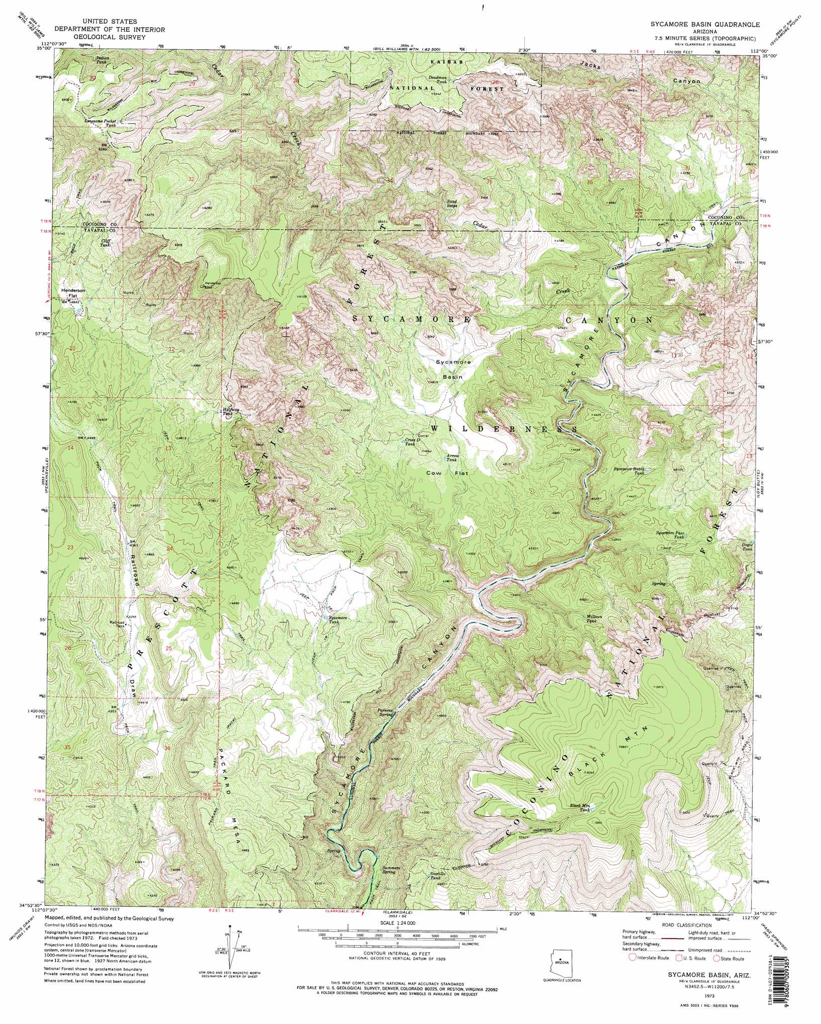
USGS Topo Quad 34112h1 - 1:24,000 scale
| Topo Map Name: | Sycamore Basin |
| USGS Topo Quad ID: | 34112h1 |
| Print Size: | ca. 21 1/4" wide x 27" high |
| Southeast Coordinates: | 34.875° N latitude / 112° W longitude |
| Map Center Coordinates: | 34.9375° N latitude / 112.0625° W longitude |
| U.S. State: | AZ |
| Filename: | o34112h1.jpg |
| Download Map JPG Image: | Sycamore Basin topo map 1:24,000 scale |
| Map Type: | Topographic |
| Topo Series: | 7.5´ |
| Map Scale: | 1:24,000 |
| Source of Map Images: | United States Geological Survey (USGS) |
| Alternate Map Versions: |
Sycamore Basin AZ 1973, updated 1977 Download PDF Buy paper map Sycamore Basin AZ 1973, updated 1977 Download PDF Buy paper map Sycamore Basin AZ 2012 Download PDF Buy paper map Sycamore Basin AZ 2014 Download PDF Buy paper map |
| FStopo: | US Forest Service topo Sycamore Basin is available: Download FStopo PDF Download FStopo TIF |
1:24,000 Topo Quads surrounding Sycamore Basin
Mclellan Reservoir |
Williams South |
Davenport Hill |
Garland Prairie |
Bellemont |
Matterhorn |
May Tank Pocket |
White Horse Lake |
Sycamore Point |
Dutton Hill |
Hell Point |
Perkinsville |
Sycamore Basin |
Loy Butte |
Wilson Mountain |
King Canyon |
Munds Draw |
Clarkdale |
Page Springs |
Sedona |
Prescott Valley North |
Hickey Mountain |
Cottonwood |
Cornville |
Lake Montezuma |
> Back to 34112e1 at 1:100,000 scale
> Back to 34112a1 at 1:250,000 scale
> Back to U.S. Topo Maps home
Sycamore Basin topo map: Gazetteer
Sycamore Basin: Basins
Sycamore Basin elevation 1421m 4662′Sycamore Basin: Flats
Cow Flat elevation 1378m 4520′Henderson Flat elevation 1486m 4875′
Sycamore Basin: Reservoirs
Arrow Tank elevation 1390m 4560′Black Mountain Tank elevation 1742m 5715′
Cliff Tank elevation 1589m 5213′
Cross D Tank elevation 1395m 4576′
Deadman Tank elevation 1939m 6361′
Dogie Tank elevation 1418m 4652′
Halfway Tank elevation 1466m 4809′
Henderson Tank elevation 1465m 4806′
Indian Tank elevation 1943m 6374′
Indian Tank elevation 1830m 6003′
Lonesome Pocket Tank elevation 1924m 6312′
Lost Arrow Head Tank elevation 1396m 4580′
Ocotillo Tank elevation 1347m 4419′
Railroad Tank elevation 1315m 4314′
Sycamore Basin Tank elevation 1336m 4383′
Sycamore Pass Tank elevation 1359m 4458′
Sycamore Tank elevation 1403m 4603′
Williams Tank elevation 1388m 4553′
Willows Tank elevation 1377m 4517′
Sycamore Basin: Springs
Parsons Spring elevation 1146m 3759′Sand Seeps elevation 1456m 4776′
Summers Spring elevation 1113m 3651′
Sycamore Basin: Streams
Cedar Creek elevation 1286m 4219′Sycamore Basin: Summits
Black Mountain elevation 1844m 6049′Packard Mesa elevation 1433m 4701′
Sycamore Basin: Trails
Pack Trail elevation 1565m 5134′Packard Trail elevation 1428m 4685′
Sycamore Basin Trail elevation 1388m 4553′
Sycamore Basin: Wells
Ott Well elevation 1384m 4540′Railroad Well elevation 1304m 4278′
Sycamore Basin digital topo map on disk
Buy this Sycamore Basin topo map showing relief, roads, GPS coordinates and other geographical features, as a high-resolution digital map file on DVD: