Thorn Peak Topo Map Arizona
To zoom in, hover over the map of Thorn Peak
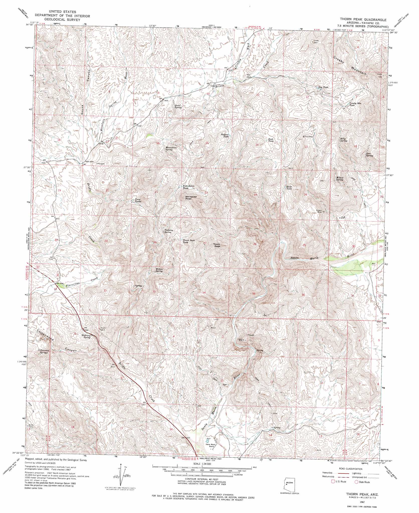
USGS Topo Quad 34113d2 - 1:24,000 scale
| Topo Map Name: | Thorn Peak |
| USGS Topo Quad ID: | 34113d2 |
| Print Size: | ca. 21 1/4" wide x 27" high |
| Southeast Coordinates: | 34.375° N latitude / 113.125° W longitude |
| Map Center Coordinates: | 34.4375° N latitude / 113.1875° W longitude |
| U.S. State: | AZ |
| Filename: | o34113d2.jpg |
| Download Map JPG Image: | Thorn Peak topo map 1:24,000 scale |
| Map Type: | Topographic |
| Topo Series: | 7.5´ |
| Map Scale: | 1:24,000 |
| Source of Map Images: | United States Geological Survey (USGS) |
| Alternate Map Versions: |
Thorn Peak AZ 1967, updated 1969 Download PDF Buy paper map Thorn Peak AZ 1967, updated 1983 Download PDF Buy paper map Thorn Peak AZ 2011 Download PDF Buy paper map Thorn Peak AZ 2014 Download PDF Buy paper map |
1:24,000 Topo Quads surrounding Thorn Peak
Elephant Mountain |
Negro Ed |
Bozarth Mesa |
Behm Mesa |
Sheridan Mountain |
Kaiser Spring |
Grayback Mountains |
Bagdad |
Big Shipp Mountain |
Muleshoe Ranch |
Arrastra Mountain |
Arrastra Mountain Ne |
Thorn Peak |
Malpais Mesa Ne |
Hillside |
Palmerita Ranch |
Arrastra Mountain Se |
Ives Peak |
Malpais Mesa |
Date |
Smith Peak Nw |
Smith Peak Ne |
Date Creek Ranch Nw |
Date Creek Ranch |
O'Neill Pass |
> Back to 34113a1 at 1:100,000 scale
> Back to 34112a1 at 1:250,000 scale
> Back to U.S. Topo Maps home
Thorn Peak topo map: Gazetteer
Thorn Peak: Mines
Sultan Mine elevation 840m 2755′Thorn Peak: Reservoirs
Crosby Mountain Tank elevation 1026m 3366′Dry Tank elevation 953m 3126′
Fort Basin Tank elevation 956m 3136′
Pastore Tank elevation 961m 3152′
River Tank elevation 977m 3205′
Rock Tank elevation 1023m 3356′
Thorn Peak Tank elevation 936m 3070′
Twin Tanks elevation 903m 2962′
Thorn Peak: Springs
Billy Spring elevation 916m 3005′Cottonwood Springs elevation 777m 2549′
Deer Spring elevation 889m 2916′
Highway Spring elevation 705m 2312′
Moonshine Spring elevation 843m 2765′
Quail Spring elevation 848m 2782′
Tindsley Spring elevation 873m 2864′
Willow Spring elevation 745m 2444′
Willow Spring elevation 911m 2988′
Thorn Peak: Streams
Bridle Creek elevation 543m 1781′Cowboy Wash elevation 886m 2906′
Mountain Spring Wash elevation 781m 2562′
Placeritas Creek elevation 698m 2290′
Thorn Peak: Summits
Crosby Mountain elevation 1320m 4330′Hayes Peak elevation 1248m 4094′
Thorn Peak elevation 1161m 3809′
Whitecap Peak elevation 1112m 3648′
Thorn Peak: Valleys
Cottonwood Canyon elevation 618m 2027′Skunk Canyon elevation 783m 2568′
Thorn Peak digital topo map on disk
Buy this Thorn Peak topo map showing relief, roads, GPS coordinates and other geographical features, as a high-resolution digital map file on DVD: