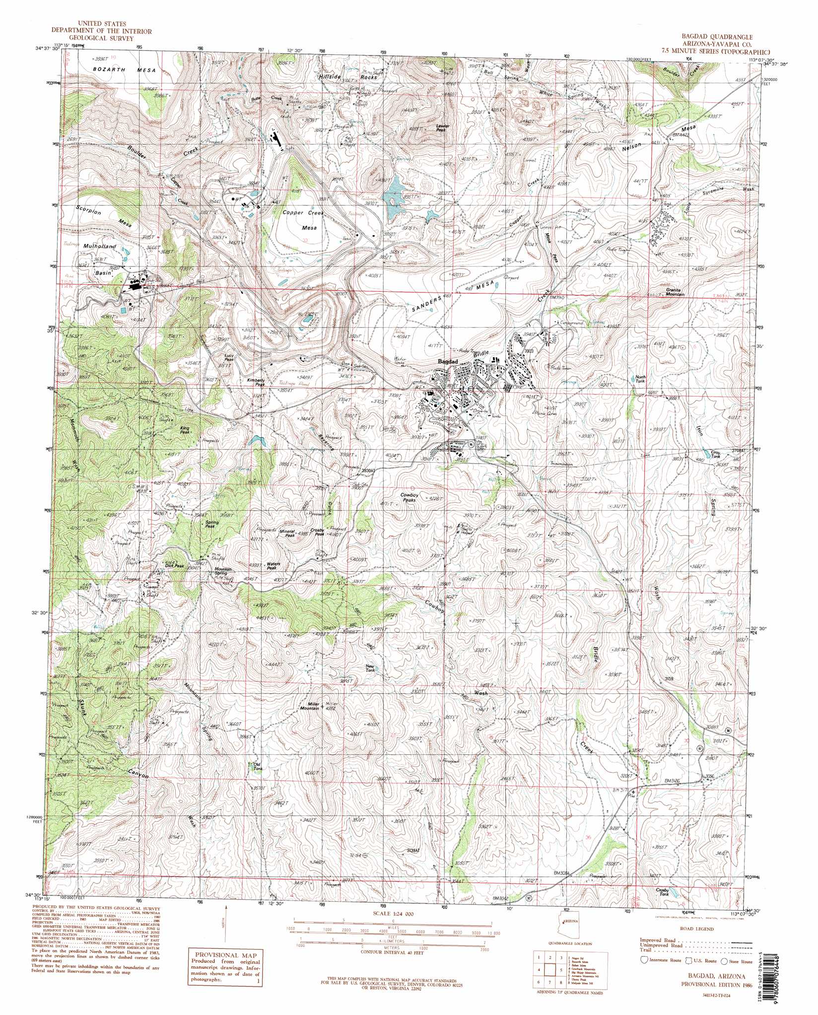
Bagdad Topo Map Arizona
To zoom in, hover over the map of Bagdad
USGS Topo Quad 34113e2 - 1:24,000 scale
| Topo Map Name: | Bagdad |
| USGS Topo Quad ID: | 34113e2 |
| Print Size: | ca. 21 1/4" wide x 27" high |
| Southeast Coordinates: | 34.5° N latitude / 113.125° W longitude |
| Map Center Coordinates: | 34.5625° N latitude / 113.1875° W longitude |
| U.S. State: | AZ |
| Filename: | o34113e2.jpg |
| Download Map JPG Image: | Bagdad topo map 1:24,000 scale |
| Map Type: | Topographic |
| Topo Series: | 7.5´ |
| Map Scale: | 1:24,000 |
| Source of Map Images: | United States Geological Survey (USGS) |
| Alternate Map Versions: |
Bagdad AZ 1986, updated 1986 Download PDF Buy paper map Bagdad AZ 2011 Download PDF Buy paper map Bagdad AZ 2014 Download PDF Buy paper map |
1:24,000 Topo Quads surrounding Bagdad
Cedar Basin |
Pilot Knob |
Burro Mesa |
Scratch Canyon |
Camp Wood |
Elephant Mountain |
Negro Ed |
Bozarth Mesa |
Behm Mesa |
Sheridan Mountain |
Kaiser Spring |
Grayback Mountains |
Bagdad |
Big Shipp Mountain |
Muleshoe Ranch |
Arrastra Mountain |
Arrastra Mountain Ne |
Thorn Peak |
Malpais Mesa Ne |
Hillside |
Palmerita Ranch |
Arrastra Mountain Se |
Ives Peak |
Malpais Mesa |
Date |
> Back to 34113e1 at 1:100,000 scale
> Back to 34112a1 at 1:250,000 scale
> Back to U.S. Topo Maps home
Bagdad topo map: Gazetteer
Bagdad: Airports
Bagdad Airport elevation 1272m 4173′Bagdad: Basins
Mulholland Basin elevation 1125m 3690′Bagdad: Dams
Bagdad Tailings Dam elevation 1197m 3927′Bagdad: Gaps
Mesa Pass elevation 1236m 4055′Bagdad: Mines
Bagdad Open Pit Mine elevation 910m 2985′Comstock-Dexter Mine elevation 988m 3241′
Copper King Mine elevation 1185m 3887′
Cowboy Mine elevation 1160m 3805′
Kyeke Mine elevation 940m 3083′
Old Dick Mine elevation 1169m 3835′
Bagdad: Populated Places
Bagdad elevation 1007m 3303′Bagdad: Post Offices
Bagdad Post Office elevation 1155m 3789′Bagdad: Reservoirs
Crosby Tank elevation 1033m 3389′Bagdad: Springs
Mountain Spring elevation 1175m 3854′White Spring elevation 1168m 3832′
Bagdad: Streams
Alum Creek elevation 921m 3021′Butte Creek elevation 873m 2864′
Copper Creek elevation 844m 2769′
Mineral Creek elevation 959m 3146′
Niagara Creek elevation 879m 2883′
Spring Creek elevation 871m 2857′
White Spring Wash elevation 1154m 3786′
Bagdad: Summits
Black Mesa elevation 1124m 3687′Centipede Mesa elevation 1216m 3989′
Copper Creek Mesa elevation 1248m 4094′
Cowboy Peaks elevation 1288m 4225′
Crosby Peak elevation 1337m 4386′
Dick Peak elevation 1254m 4114′
Granite Mountain elevation 1417m 4648′
Hillside Rocks elevation 1134m 3720′
Kimberly Peak elevation 1074m 3523′
King Peak elevation 1261m 4137′
Lawler Peak elevation 1457m 4780′
Lucy Peak elevation 1140m 3740′
Miller Mountain elevation 1321m 4333′
Mineral Peak elevation 1332m 4370′
Nelson Mesa elevation 1347m 4419′
Sanders Mesa elevation 0m 0′
Spring Peak elevation 1262m 4140′
Waters Peak elevation 1330m 4363′
Bagdad: Valleys
Bevering Gulch elevation 1057m 3467′Maroney Gulch elevation 1057m 3467′
Bagdad digital topo map on disk
Buy this Bagdad topo map showing relief, roads, GPS coordinates and other geographical features, as a high-resolution digital map file on DVD: