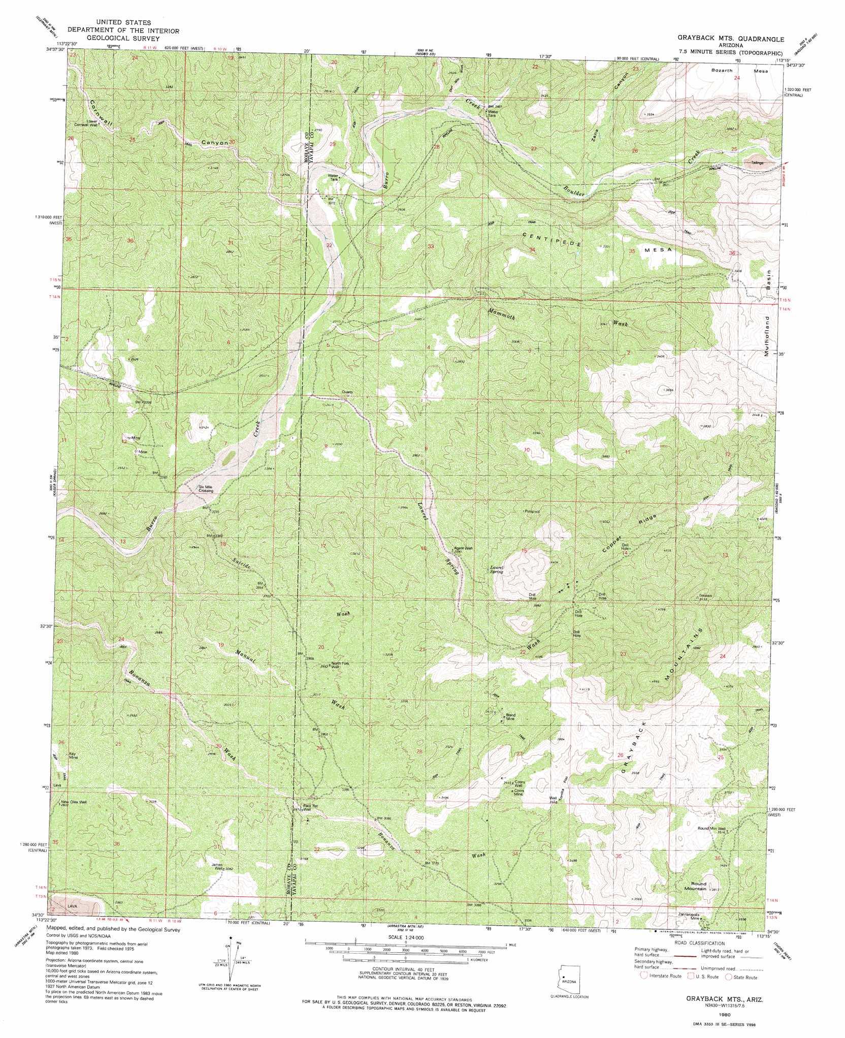
Grayback Mountains Topo Map Arizona
To zoom in, hover over the map of Grayback Mountains
USGS Topo Quad 34113e3 - 1:24,000 scale
| Topo Map Name: | Grayback Mountains |
| USGS Topo Quad ID: | 34113e3 |
| Print Size: | ca. 21 1/4" wide x 27" high |
| Southeast Coordinates: | 34.5° N latitude / 113.25° W longitude |
| Map Center Coordinates: | 34.5625° N latitude / 113.3125° W longitude |
| U.S. State: | AZ |
| Filename: | o34113e3.jpg |
| Download Map JPG Image: | Grayback Mountains topo map 1:24,000 scale |
| Map Type: | Topographic |
| Topo Series: | 7.5´ |
| Map Scale: | 1:24,000 |
| Source of Map Images: | United States Geological Survey (USGS) |
| Alternate Map Versions: |
Grayback Mts. AZ 1980, updated 1980 Download PDF Buy paper map Grayback Mountains AZ 2011 Download PDF Buy paper map Grayback Mountains AZ 2014 Download PDF Buy paper map |
1:24,000 Topo Quads surrounding Grayback Mountains
Tule Wash |
Cedar Basin |
Pilot Knob |
Burro Mesa |
Scratch Canyon |
Wikieup |
Elephant Mountain |
Negro Ed |
Bozarth Mesa |
Behm Mesa |
Greenwood Peak |
Kaiser Spring |
Grayback Mountains |
Bagdad |
Big Shipp Mountain |
Signal Mountain |
Arrastra Mountain |
Arrastra Mountain Ne |
Thorn Peak |
Malpais Mesa Ne |
Artillery Peak |
Palmerita Ranch |
Arrastra Mountain Se |
Ives Peak |
Malpais Mesa |
> Back to 34113e1 at 1:100,000 scale
> Back to 34112a1 at 1:250,000 scale
> Back to U.S. Topo Maps home
Grayback Mountains topo map: Gazetteer
Grayback Mountains: Arroyos
Deer Mountain Wash elevation 741m 2431′Manuel Wash elevation 668m 2191′
Mulholland Wash elevation 790m 2591′
Suicide Wash elevation 682m 2237′
Grayback Mountains: Flats
Tortilla Flat elevation 1078m 3536′Grayback Mountains: Mines
Bland Mine elevation 1036m 3398′Coors Mine elevation 1065m 3494′
Key Mine elevation 891m 2923′
Zannaropolis Mine elevation 1063m 3487′
Grayback Mountains: Populated Places
Six Mile Crossing elevation 678m 2224′Grayback Mountains: Ranges
Grayback Mountains elevation 1513m 4963′Grayback Mountains: Ridges
Copper Ridge elevation 1328m 4356′Grayback Mountains: Springs
Laurel Spring elevation 975m 3198′Grayback Mountains: Streams
Boulder Creek elevation 765m 2509′Mammoth Wash elevation 782m 2565′
Grayback Mountains: Summits
Round Mountain elevation 1159m 3802′Grayback Mountains: Valleys
Cornwall Canyon elevation 718m 2355′Grayback Mountains: Wells
Agate Well elevation 903m 2962′Coors Well elevation 1051m 3448′
Lower Cornwall Well elevation 922m 3024′
New Olea Well elevation 863m 2831′
North Fork Well elevation 903m 2962′
Pack Rat Well elevation 907m 2975′
Round Mountain Well elevation 1074m 3523′
Grayback Mountains digital topo map on disk
Buy this Grayback Mountains topo map showing relief, roads, GPS coordinates and other geographical features, as a high-resolution digital map file on DVD: