Bozarth Mesa Topo Map Arizona
To zoom in, hover over the map of Bozarth Mesa
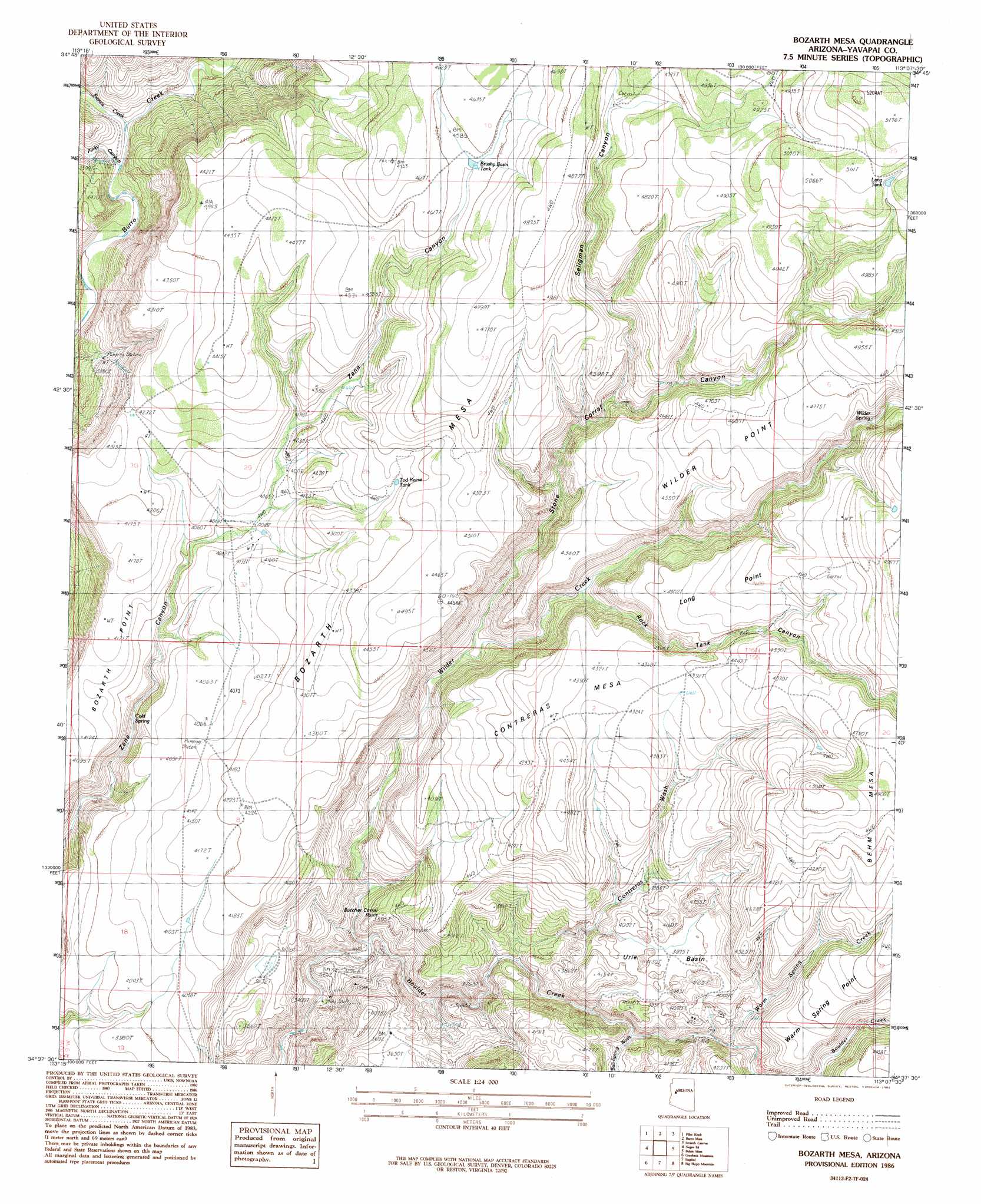
USGS Topo Quad 34113f2 - 1:24,000 scale
| Topo Map Name: | Bozarth Mesa |
| USGS Topo Quad ID: | 34113f2 |
| Print Size: | ca. 21 1/4" wide x 27" high |
| Southeast Coordinates: | 34.625° N latitude / 113.125° W longitude |
| Map Center Coordinates: | 34.6875° N latitude / 113.1875° W longitude |
| U.S. State: | AZ |
| Filename: | o34113f2.jpg |
| Download Map JPG Image: | Bozarth Mesa topo map 1:24,000 scale |
| Map Type: | Topographic |
| Topo Series: | 7.5´ |
| Map Scale: | 1:24,000 |
| Source of Map Images: | United States Geological Survey (USGS) |
| Alternate Map Versions: |
Bozarth Mesa AZ 2011 Download PDF Buy paper map Bozarth Mesa AZ 2014 Download PDF Buy paper map |
1:24,000 Topo Quads surrounding Bozarth Mesa
Gonzales Wash |
Mohon Peak |
Sunrise Peak |
Mount Hope |
Juniper Mountains |
Cedar Basin |
Pilot Knob |
Burro Mesa |
Scratch Canyon |
Camp Wood |
Elephant Mountain |
Negro Ed |
Bozarth Mesa |
Behm Mesa |
Sheridan Mountain |
Kaiser Spring |
Grayback Mountains |
Bagdad |
Big Shipp Mountain |
Muleshoe Ranch |
Arrastra Mountain |
Arrastra Mountain Ne |
Thorn Peak |
Malpais Mesa Ne |
Hillside |
> Back to 34113e1 at 1:100,000 scale
> Back to 34112a1 at 1:250,000 scale
> Back to U.S. Topo Maps home
Bozarth Mesa topo map: Gazetteer
Bozarth Mesa: Basins
Urie Basin elevation 1219m 3999′Bozarth Mesa: Capes
Bozarth Point elevation 1257m 4124′Warm Spring Point elevation 1321m 4333′
Bozarth Mesa: Cliffs
Butcher Corral Point elevation 1192m 3910′Long Point elevation 1296m 4251′
Wilder Point elevation 1407m 4616′
Bozarth Mesa: Mines
Hillside Mine elevation 944m 3097′Bozarth Mesa: Reservoirs
Brushy Basin Tank elevation 1390m 4560′Lang Tank elevation 1540m 5052′
Tod Reese Tank elevation 1314m 4311′
Bozarth Mesa: Springs
Cold Spring elevation 1130m 3707′Urie Spring elevation 1183m 3881′
Warm Spring elevation 1193m 3914′
Wilder Spring elevation 1379m 4524′
Bozarth Mesa: Streams
Bull Spring Wash elevation 1108m 3635′Contreras Wash elevation 1033m 3389′
Francis Creek elevation 937m 3074′
Warm Spring Creek elevation 1161m 3809′
Wilder Creek elevation 948m 3110′
Bozarth Mesa: Summits
Bozarth Mesa elevation 1483m 4865′Contreras Mesa elevation 1357m 4452′
Bozarth Mesa: Valleys
Pinky Canyon elevation 938m 3077′Rock Tank Canyon elevation 1166m 3825′
Seligman Canyon elevation 0m 0′
Stone Corral Canyon elevation 1073m 3520′
Zana Canyon elevation 1159m 3802′
Bozarth Mesa digital topo map on disk
Buy this Bozarth Mesa topo map showing relief, roads, GPS coordinates and other geographical features, as a high-resolution digital map file on DVD: