Mohon Peak Topo Map Arizona
To zoom in, hover over the map of Mohon Peak
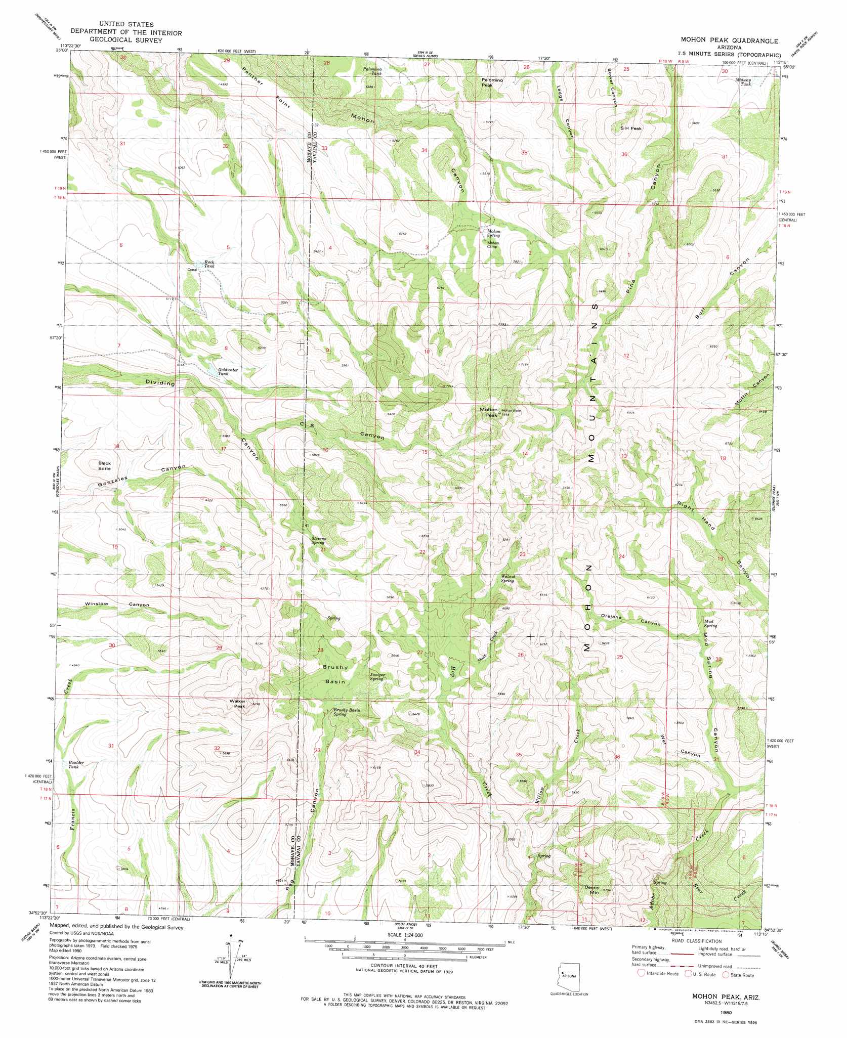
USGS Topo Quad 34113h3 - 1:24,000 scale
| Topo Map Name: | Mohon Peak |
| USGS Topo Quad ID: | 34113h3 |
| Print Size: | ca. 21 1/4" wide x 27" high |
| Southeast Coordinates: | 34.875° N latitude / 113.25° W longitude |
| Map Center Coordinates: | 34.9375° N latitude / 113.3125° W longitude |
| U.S. State: | AZ |
| Filename: | o34113h3.jpg |
| Download Map JPG Image: | Mohon Peak topo map 1:24,000 scale |
| Map Type: | Topographic |
| Topo Series: | 7.5´ |
| Map Scale: | 1:24,000 |
| Source of Map Images: | United States Geological Survey (USGS) |
| Alternate Map Versions: |
Mohon Peak AZ 1980, updated 1980 Download PDF Buy paper map Mohon Peak AZ 2011 Download PDF Buy paper map Mohon Peak AZ 2014 Download PDF Buy paper map |
1:24,000 Topo Quads surrounding Mohon Peak
Tin Mountain |
Bull Spring |
Fort Rock Ranch |
Cross Mountain |
Squaw Peak |
Austin Peak |
Penitentiary Mountain |
Devils Hump |
Anvil Rock Ranch |
Anvil Rock |
Tom Brown Canyon |
Gonzales Wash |
Mohon Peak |
Sunrise Peak |
Mount Hope |
Tule Wash |
Cedar Basin |
Pilot Knob |
Burro Mesa |
Scratch Canyon |
Wikieup |
Elephant Mountain |
Negro Ed |
Bozarth Mesa |
Behm Mesa |
> Back to 34113e1 at 1:100,000 scale
> Back to 34112a1 at 1:250,000 scale
> Back to U.S. Topo Maps home
Mohon Peak topo map: Gazetteer
Mohon Peak: Basins
Brushy Basin elevation 1557m 5108′Mohon Peak: Ranges
Mohon Mountains elevation 2118m 6948′Mohon Peak: Reservoirs
Boulder Tank elevation 1442m 4730′Goldwater Tank elevation 1577m 5173′
Midway Tank elevation 1617m 5305′
Palomino Tank elevation 1568m 5144′
Rock Tank elevation 1526m 5006′
Mohon Peak: Ridges
Panther Point elevation 1550m 5085′Mohon Peak: Springs
Brushy Basin Spring elevation 1525m 5003′Juniper Spring elevation 1564m 5131′
Mohon Spring elevation 1649m 5410′
Mud Spring elevation 1647m 5403′
Stevens Spring elevation 1647m 5403′
Walnut Spring elevation 1690m 5544′
Mohon Peak: Streams
Bear Creek elevation 1499m 4917′Short Creek elevation 1632m 5354′
Willow Creek elevation 1431m 4694′
Mohon Peak: Summits
Black Butte elevation 1614m 5295′Denny Mountain elevation 1755m 5757′
Mohon Peak elevation 2278m 7473′
Palomino Peak elevation 1856m 6089′
S H Peak elevation 1939m 6361′
Walker Peak elevation 1895m 6217′
Mohon Peak: Valleys
C S Canyon elevation 1569m 5147′Mud Spring Canyon elevation 1525m 5003′
Orejana Canyon elevation 1625m 5331′
Right Hand Canyon elevation 1547m 5075′
Wet Canyon elevation 1540m 5052′
Mohon Peak digital topo map on disk
Buy this Mohon Peak topo map showing relief, roads, GPS coordinates and other geographical features, as a high-resolution digital map file on DVD: