Big Bear City Topo Map California
To zoom in, hover over the map of Big Bear City
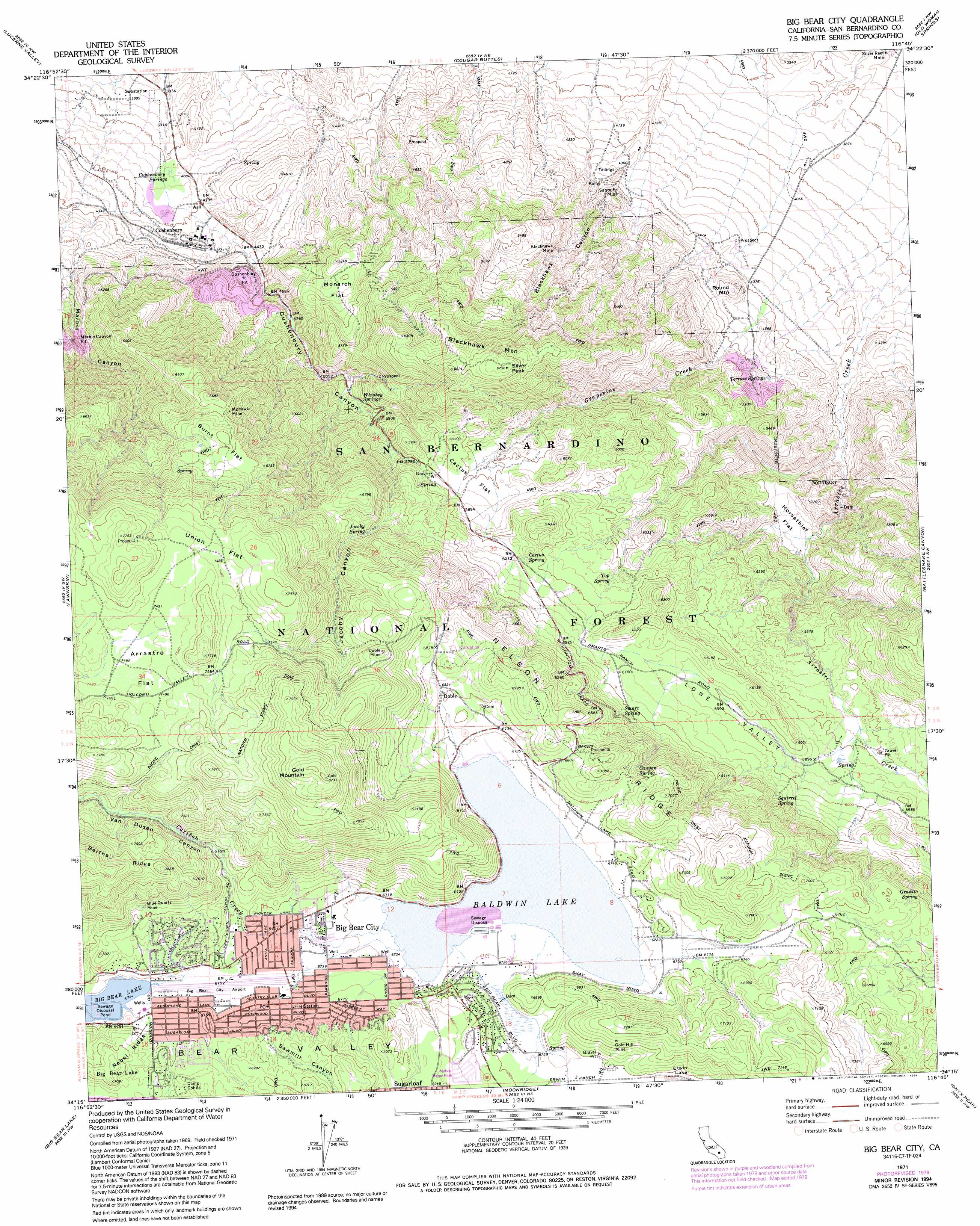
USGS Topo Quad 34116c7 - 1:24,000 scale
| Topo Map Name: | Big Bear City |
| USGS Topo Quad ID: | 34116c7 |
| Print Size: | ca. 21 1/4" wide x 27" high |
| Southeast Coordinates: | 34.25° N latitude / 116.75° W longitude |
| Map Center Coordinates: | 34.3125° N latitude / 116.8125° W longitude |
| U.S. State: | CA |
| Filename: | o34116c7.jpg |
| Download Map JPG Image: | Big Bear City topo map 1:24,000 scale |
| Map Type: | Topographic |
| Topo Series: | 7.5´ |
| Map Scale: | 1:24,000 |
| Source of Map Images: | United States Geological Survey (USGS) |
| Alternate Map Versions: |
Big Bear City CA 1971, updated 1975 Download PDF Buy paper map Big Bear City CA 1971, updated 1975 Download PDF Buy paper map Big Bear City CA 1971, updated 1975 Download PDF Buy paper map Big Bear City CA 1971, updated 1980 Download PDF Buy paper map Big Bear City CA 1971, updated 1980 Download PDF Buy paper map Big Bear City CA 1971, updated 1994 Download PDF Buy paper map Big Bear City CA 1971, updated 1994 Download PDF Buy paper map Big Bear City CA 1996, updated 1999 Download PDF Buy paper map Big Bear City CA 2012 Download PDF Buy paper map Big Bear City CA 2015 Download PDF Buy paper map |
| FStopo: | US Forest Service topo Big Bear City is available: Download FStopo PDF Download FStopo TIF |
1:24,000 Topo Quads surrounding Big Bear City
Fairview Valley |
White Horse Mountain |
Grand View Mine |
Fry Mountains |
Iron Ridge |
Fifteenmile Valley |
Lucerne Valley |
Cougar Buttes |
Old Woman Springs |
Melville Lake |
Butler Peak |
Fawnskin |
Big Bear City |
Rattlesnake Canyon |
Bighorn Canyon |
Keller Peak |
Big Bear Lake |
Moonridge |
Onyx Peak |
Rimrock |
Yucaipa |
Forest Falls |
San Gorgonio Mountain |
Catclaw Flat |
Morongo Valley |
> Back to 34116a1 at 1:100,000 scale
> Back to 34116a1 at 1:250,000 scale
> Back to U.S. Topo Maps home
Big Bear City topo map: Gazetteer
Big Bear City: Airports
Big Bear City Airport elevation 2056m 6745′Big Bear City: Basins
Bear Valley elevation 2063m 6768′Lone Valley elevation 1831m 6007′
Big Bear City: Flats
Arrastre Flat elevation 2281m 7483′Burnt Flat elevation 2072m 6797′
Cactus Flat elevation 1771m 5810′
Horsethief Flat elevation 1489m 4885′
Monarch Flat elevation 1596m 5236′
Union Flat elevation 2282m 7486′
Big Bear City: Lakes
Baldwin Lake elevation 2041m 6696′Big Bear City: Mines
Blackhawk Mine elevation 1477m 4845′Blue Quartz Mine elevation 2158m 7080′
Cushenbury Pit elevation 1413m 4635′
Doble Mine elevation 2228m 7309′
Gold Hill Mine elevation 2173m 7129′
Marble Canyon Pit elevation 1559m 5114′
Mohawk Mine elevation 1961m 6433′
Santa Fe Mine elevation 1340m 4396′
Big Bear City: Parks
Big Bear City Park elevation 2055m 6742′Gold Mountain Memorial Park elevation 2110m 6922′
Big Bear City: Populated Places
Baldwin Lake elevation 2058m 6751′Big Bear City elevation 2064m 6771′
Cushenbury elevation 1314m 4311′
Doble elevation 2076m 6811′
Big Bear City: Post Offices
Baldwin Lake Post Office (historical) elevation 2058m 6751′Big Bear City Post Office elevation 2062m 6765′
Big Bear City: Ridges
Blackhawk Mountain elevation 2052m 6732′Nelson Ridge elevation 2120m 6955′
Rebel Ridge elevation 2130m 6988′
Big Bear City: Springs
Cactus Spring elevation 1868m 6128′Canyon Spring elevation 2032m 6666′
Cushenbury Springs elevation 1241m 4071′
Granite Spring elevation 1985m 6512′
Jacoby Spring elevation 1935m 6348′
Saragossa Spring elevation 2291m 7516′
Smart Spring elevation 1916m 6286′
Squirrel Spring elevation 1890m 6200′
Terrace Springs elevation 1414m 4639′
Top Spring elevation 1787m 5862′
Whiskey Springs elevation 1611m 5285′
Big Bear City: Streams
Caribou Creek elevation 2046m 6712′Grapevine Creek elevation 1359m 4458′
Big Bear City: Summits
Gold Mountain elevation 2502m 8208′Round Mountain elevation 1430m 4691′
Silver Peak elevation 2053m 6735′
Big Bear City: Valleys
Blackhawk Canyon elevation 1195m 3920′Cushenbury Canyon elevation 1270m 4166′
Jacoby Canyon elevation 1915m 6282′
Marble Canyon elevation 1277m 4189′
Sawmill Canyon elevation 2072m 6797′
Van Dusen Canyon elevation 2065m 6774′
Big Bear City digital topo map on disk
Buy this Big Bear City topo map showing relief, roads, GPS coordinates and other geographical features, as a high-resolution digital map file on DVD: