Guasti Topo Map California
To zoom in, hover over the map of Guasti
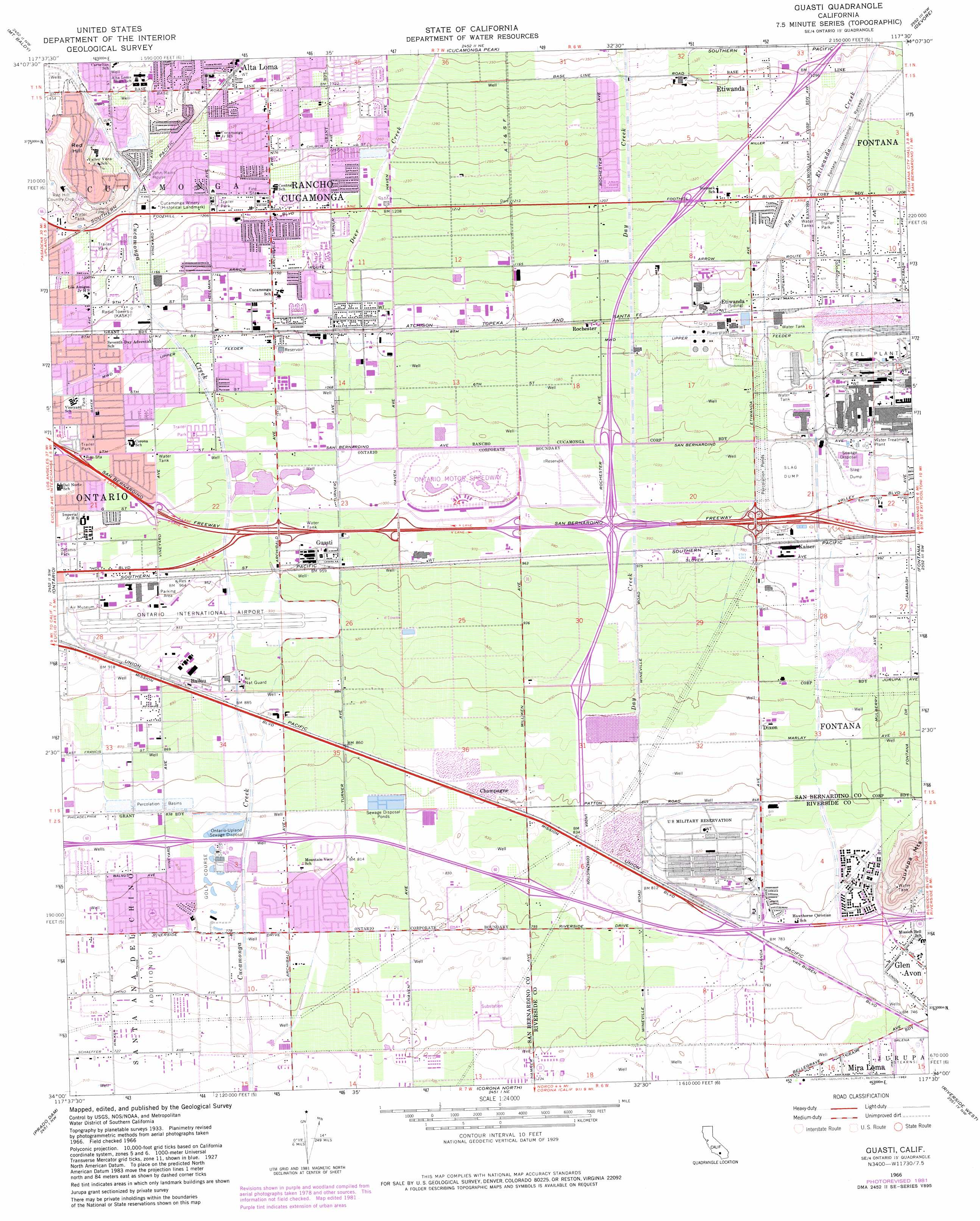
USGS Topo Quad 34117a5 - 1:24,000 scale
| Topo Map Name: | Guasti |
| USGS Topo Quad ID: | 34117a5 |
| Print Size: | ca. 21 1/4" wide x 27" high |
| Southeast Coordinates: | 34° N latitude / 117.5° W longitude |
| Map Center Coordinates: | 34.0625° N latitude / 117.5625° W longitude |
| U.S. State: | CA |
| Filename: | o34117a5.jpg |
| Download Map JPG Image: | Guasti topo map 1:24,000 scale |
| Map Type: | Topographic |
| Topo Series: | 7.5´ |
| Map Scale: | 1:24,000 |
| Source of Map Images: | United States Geological Survey (USGS) |
| Alternate Map Versions: |
Guasti CA 1953, updated 1955 Download PDF Buy paper map Guasti CA 1953, updated 1961 Download PDF Buy paper map Guasti CA 1966, updated 1969 Download PDF Buy paper map Guasti CA 1966, updated 1975 Download PDF Buy paper map Guasti CA 1966, updated 1982 Download PDF Buy paper map Guasti CA 1966, updated 1982 Download PDF Buy paper map Guasti CA 2012 Download PDF Buy paper map Guasti CA 2015 Download PDF Buy paper map |
1:24,000 Topo Quads surrounding Guasti
Crystal Lake |
Mount San Antonio |
Telegraph Peak |
Cajon |
Silverwood Lake |
Glendora |
Mount Baldy |
Cucamonga Peak |
Devore |
San Bernardino North |
San Dimas |
Ontario |
Guasti |
Fontana |
San Bernardino South |
Yorba Linda |
Prado Dam |
Corona North |
Riverside West |
Riverside East |
Orange |
Black Star Canyon |
Corona South |
Lake Mathews |
Steele Peak |
> Back to 34117a1 at 1:100,000 scale
> Back to 34116a1 at 1:250,000 scale
> Back to U.S. Topo Maps home
Guasti topo map: Gazetteer
Guasti: Airports
Ontario International Airport elevation 282m 925′Guasti: Crossings
Inland Empire Interchange elevation 305m 1000′Interchange 106 elevation 246m 807′
Interchange 108 elevation 277m 908′
Interchange 109A elevation 304m 997′
Interchange 109B elevation 306m 1003′
Interchange 110 elevation 319m 1046′
Interchange 112 elevation 367m 1204′
Interchange 113 elevation 395m 1295′
Interchange 59 elevation 306m 1003′
Guasti: Parks
Bear Gulch Park elevation 355m 1164′Chaffey-Garcia House Historic Site elevation 405m 1328′
Church Street Park elevation 386m 1266′
Cucamonga Winery Historical Landmark elevation 378m 1240′
Cucamonga-Gusti Regional Park elevation 306m 1003′
Don Tiburcio Tapia State Park elevation 434m 1423′
Galanis Park elevation 301m 987′
Lions Park elevation 421m 1381′
Old Town Park elevation 340m 1115′
Quakes Park elevation 358m 1174′
Rancho Cucamonga Central Park elevation 409m 1341′
Rancho Cucamonga Sports Complex elevation 356m 1167′
Red Hill Community Park elevation 434m 1423′
Victoria Lakes Park elevation 385m 1263′
Vineyard Park elevation 334m 1095′
Guasti: Populated Places
Alta Loma elevation 420m 1377′Ballou elevation 275m 902′
Champagne elevation 261m 856′
Collins (historical) elevation 263m 862′
Creekside elevation 241m 790′
Etiwa (historical) elevation 305m 1000′
Guasti elevation 296m 971′
North Cucamonga elevation 342m 1122′
Racimo elevation 294m 964′
Rancho Cucamonga elevation 368m 1207′
Rochester elevation 341m 1118′
Stalder elevation 244m 800′
Guasti: Post Offices
Etiwanda Branch Rancho Cucamonga Post Office elevation 386m 1266′Etiwanda Post Office elevation 385m 1263′
Guasti Post Office elevation 293m 961′
Ontario Post Office elevation 298m 977′
Guasti: Streams
Day Creek elevation 251m 823′Deer Creek elevation 309m 1013′
East Etiwanda Creek elevation 326m 1069′
Guasti: Summits
Red Hill elevation 449m 1473′Guasti digital topo map on disk
Buy this Guasti topo map showing relief, roads, GPS coordinates and other geographical features, as a high-resolution digital map file on DVD: