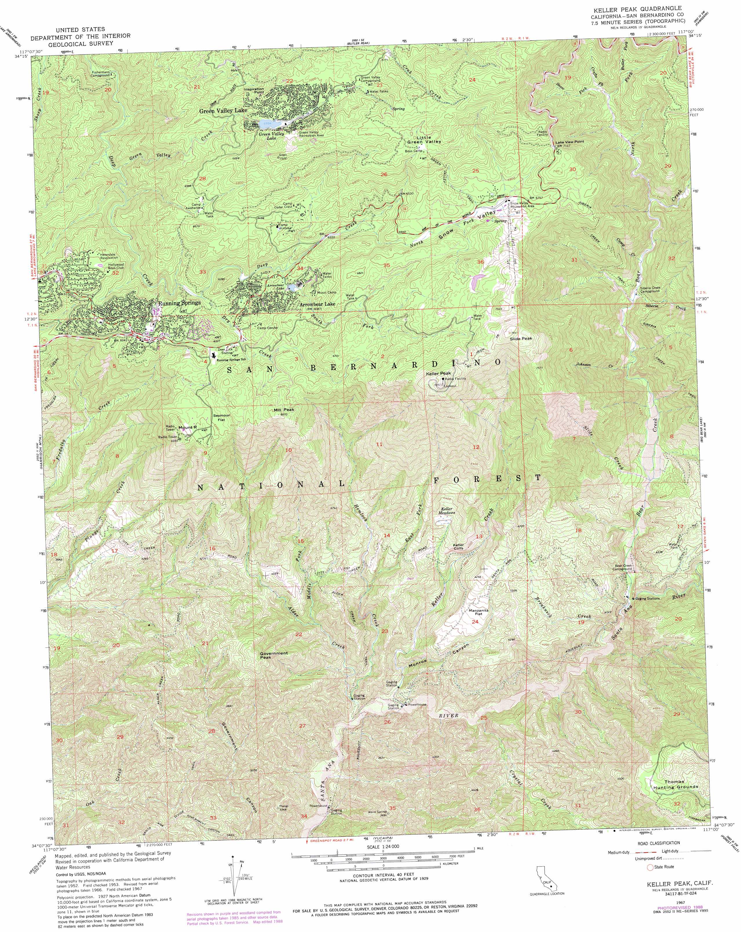
Keller Peak Topo Map California
To zoom in, hover over the map of Keller Peak
USGS Topo Quad 34117b1 - 1:24,000 scale
| Topo Map Name: | Keller Peak |
| USGS Topo Quad ID: | 34117b1 |
| Print Size: | ca. 21 1/4" wide x 27" high |
| Southeast Coordinates: | 34.125° N latitude / 117° W longitude |
| Map Center Coordinates: | 34.1875° N latitude / 117.0625° W longitude |
| U.S. State: | CA |
| Filename: | o34117b1.jpg |
| Download Map JPG Image: | Keller Peak topo map 1:24,000 scale |
| Map Type: | Topographic |
| Topo Series: | 7.5´ |
| Map Scale: | 1:24,000 |
| Source of Map Images: | United States Geological Survey (USGS) |
| Alternate Map Versions: |
Keller Peak CA 1953, updated 1955 Download PDF Buy paper map Keller Peak CA 1953, updated 1959 Download PDF Buy paper map Keller Peak CA 1967, updated 1968 Download PDF Buy paper map Keller Peak CA 1967, updated 1985 Download PDF Buy paper map Keller Peak CA 1967, updated 1988 Download PDF Buy paper map Keller Peak CA 1996, updated 1999 Download PDF Buy paper map Keller Peak CA 2012 Download PDF Buy paper map Keller Peak CA 2015 Download PDF Buy paper map |
| FStopo: | US Forest Service topo Keller Peak is available: Download FStopo PDF Download FStopo TIF |
1:24,000 Topo Quads surrounding Keller Peak
Hesperia |
Apple Valley South |
Fifteenmile Valley |
Lucerne Valley |
Cougar Buttes |
Silverwood Lake |
Lake Arrowhead |
Butler Peak |
Fawnskin |
Big Bear City |
San Bernardino North |
Harrison Mountain |
Keller Peak |
Big Bear Lake |
Moonridge |
San Bernardino South |
Redlands |
Yucaipa |
Forest Falls |
San Gorgonio Mountain |
Riverside East |
Sunnymead |
El Casco |
Beaumont |
Cabazon |
> Back to 34117a1 at 1:100,000 scale
> Back to 34116a1 at 1:250,000 scale
> Back to U.S. Topo Maps home
Keller Peak topo map: Gazetteer
Keller Peak: Areas
Thomas Hunting Grounds elevation 1689m 5541′Keller Peak: Capes
Inspiration Point elevation 2144m 7034′Lake View Point elevation 2167m 7109′
Keller Peak: Cliffs
Keller Cliffs elevation 1190m 3904′Keller Peak: Dams
Arrowbear Dam elevation 2180m 7152′Green Valley Lake 804 Dam elevation 2090m 6856′
Keller Peak: Flats
Manzanita Flat elevation 1224m 4015′Seymour Flat elevation 1900m 6233′
Keller Peak: Forests
National Childreaus Forest elevation 2296m 7532′Keller Peak: Lakes
Deep Creek Lake elevation 1836m 6023′Green Valley Lake elevation 2090m 6856′
Rainbow Lake elevation 1787m 5862′
Keller Peak: Populated Places
Arrowbear Lake elevation 1855m 6085′Green Valley Lake elevation 2115m 6938′
Running Springs elevation 1862m 6108′
Keller Peak: Post Offices
Arrowbear Lake Post Office (historical) elevation 1855m 6085′Green Valley Lake Post Office elevation 2099m 6886′
Running Springs Post Office elevation 1841m 6040′
Keller Peak: Reservoirs
Arrowbear Lake elevation 1875m 6151′Arrowbear Reservoir elevation 2180m 7152′
Keller Peak: Streams
Alder Creek elevation 823m 2700′Bear Creek elevation 1047m 3435′
Breakneck Creek elevation 1007m 3303′
Butter Fork elevation 1922m 6305′
Camp Creek elevation 1478m 4849′
Crafts Fork elevation 1871m 6138′
Crystal Creek elevation 1226m 4022′
Deer Creek elevation 1144m 3753′
Dry Creek elevation 1788m 5866′
East Fork Hemlock Creek elevation 1098m 3602′
Green Valley Creek elevation 1638m 5374′
Hemlock Creek elevation 829m 2719′
Johnson Creek elevation 1332m 4370′
Keller Creek elevation 865m 2837′
Middle Fork Alder Creek elevation 987m 3238′
North Fork Bear Creek elevation 1586m 5203′
North Fork Deep Creek elevation 1916m 6286′
Siberia Creek elevation 1447m 4747′
Slide Creek elevation 1187m 3894′
Snow Fork elevation 1879m 6164′
South Fork Deep Creek elevation 1853m 6079′
Keller Peak: Summits
Government Peak elevation 1394m 4573′Keller Peak elevation 2391m 7844′
Mill Peak elevation 2029m 6656′
Mount R elevation 1931m 6335′
Slide Peak elevation 2391m 7844′
Keller Peak: Swamps
Keller Meadows elevation 1279m 4196′Keller Peak: Trails
Alder Creek Trail elevation 1109m 3638′Government Canyon Trail elevation 831m 2726′
Green Valley Trail elevation 2075m 6807′
Siberia Creek Trail elevation 1835m 6020′
Siberia Creek Trail elevation 1597m 5239′
Keller Peak: Valleys
Little Green Valley elevation 2125m 6971′Monroe Canyon elevation 894m 2933′
Snow Valley elevation 1954m 6410′
Keller Peak digital topo map on disk
Buy this Keller Peak topo map showing relief, roads, GPS coordinates and other geographical features, as a high-resolution digital map file on DVD: