Victorville Topo Map California
To zoom in, hover over the map of Victorville
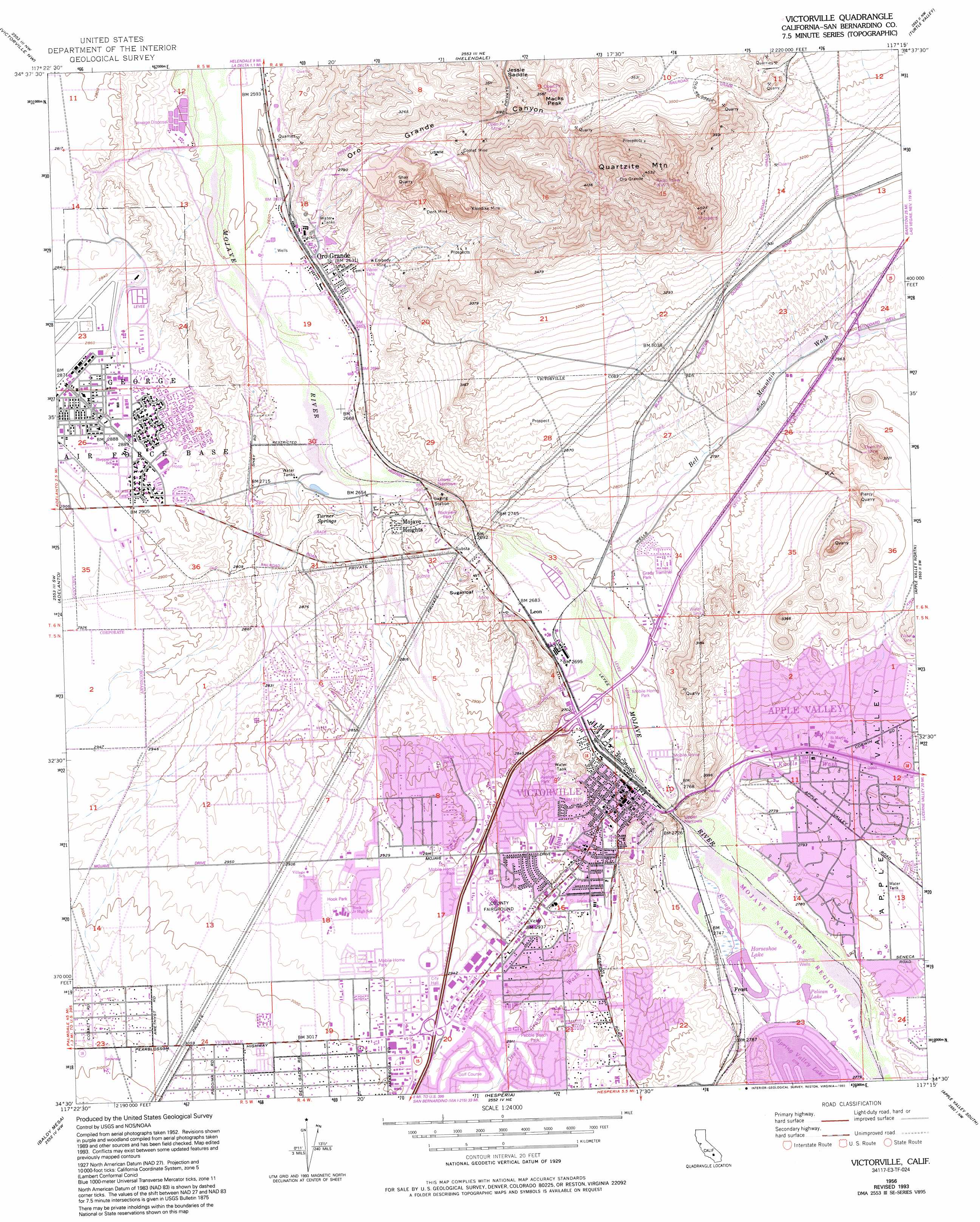
USGS Topo Quad 34117e3 - 1:24,000 scale
| Topo Map Name: | Victorville |
| USGS Topo Quad ID: | 34117e3 |
| Print Size: | ca. 21 1/4" wide x 27" high |
| Southeast Coordinates: | 34.5° N latitude / 117.25° W longitude |
| Map Center Coordinates: | 34.5625° N latitude / 117.3125° W longitude |
| U.S. State: | CA |
| Filename: | o34117e3.jpg |
| Download Map JPG Image: | Victorville topo map 1:24,000 scale |
| Map Type: | Topographic |
| Topo Series: | 7.5´ |
| Map Scale: | 1:24,000 |
| Source of Map Images: | United States Geological Survey (USGS) |
| Alternate Map Versions: |
Victorville CA 1956, updated 1957 Download PDF Buy paper map Victorville CA 1956, updated 1964 Download PDF Buy paper map Victorville CA 1956, updated 1969 Download PDF Buy paper map Victorville CA 1956, updated 1974 Download PDF Buy paper map Victorville CA 1956, updated 1982 Download PDF Buy paper map Victorville CA 1956, updated 1985 Download PDF Buy paper map Victorville CA 1956, updated 1993 Download PDF Buy paper map Victorville CA 2012 Download PDF Buy paper map Victorville CA 2015 Download PDF Buy paper map |
1:24,000 Topo Quads surrounding Victorville
Red Buttes |
Astley Rancho |
Wild Crossing |
Hodge |
Barstow Se |
Shadow Mountains |
Victorville Nw |
Helendale |
Turtle Valley |
Stoddard Well |
Shadow Mountains Se |
Adelanto |
Victorville |
Apple Valley North |
Fairview Valley |
Phelan |
Baldy Mesa |
Hesperia |
Apple Valley South |
Fifteenmile Valley |
Telegraph Peak |
Cajon |
Silverwood Lake |
Lake Arrowhead |
Butler Peak |
> Back to 34117e1 at 1:100,000 scale
> Back to 34116a1 at 1:250,000 scale
> Back to U.S. Topo Maps home
Victorville topo map: Gazetteer
Victorville: Airports
Osborne Airport elevation 879m 2883′Saint Mary Desert Valley Hospital Heliport elevation 867m 2844′
Victorville: Gaps
Jessie Saddle elevation 1062m 3484′Lower Narrows elevation 837m 2746′
Upper Narrows elevation 856m 2808′
Victorville: Lakes
Burkhardt Lake elevation 815m 2673′Victorville: Mines
Comet Mine elevation 991m 3251′Dent Mine elevation 921m 3021′
Embody Mine elevation 855m 2805′
Klondike Mine elevation 981m 3218′
Piercy Quarry elevation 957m 3139′
Shay Quarry elevation 886m 2906′
Victorville: Parks
Avalon Park elevation 886m 2906′Center Street Park elevation 850m 2788′
Corwin Road Park elevation 874m 2867′
Eva Dell Park elevation 827m 2713′
Forrest Park elevation 832m 2729′
Grady Trammel Park elevation 832m 2729′
Hook Park elevation 898m 2946′
Pebble Beach Park elevation 883m 2896′
Rockview Park elevation 834m 2736′
San Bernardino County Fairgrounds elevation 894m 2933′
Village Park elevation 884m 2900′
Victorville: Populated Places
Bellevue Heights elevation 871m 2857′Desert Knolls elevation 845m 2772′
Frost elevation 842m 2762′
Golden Mesa elevation 889m 2916′
Greentree East elevation 884m 2900′
Leon elevation 822m 2696′
Mojave Heights elevation 841m 2759′
Mountain View elevation 934m 3064′
Oro Grande elevation 811m 2660′
The Village elevation 865m 2837′
Valley High North elevation 878m 2880′
Victorville elevation 831m 2726′
Victorville: Post Offices
George Air Force Base Branch Victorville Post Office elevation 876m 2874′Oro Grande Post Office elevation 814m 2670′
Victorville Post Office elevation 878m 2880′
Victorville: Reservoirs
Horseshoe Lake elevation 836m 2742′Pelican Lake elevation 841m 2759′
Victorville: Ridges
Apple Valley Ridge elevation 936m 3070′Eldridge Ridge elevation 971m 3185′
Victorville: Springs
Turner Springs elevation 831m 2726′Victorville: Streams
Bell Mountain Wash elevation 823m 2700′Desert Knolls Wash elevation 830m 2723′
Lower Slough elevation 830m 2723′
Oro Grande Wash elevation 825m 2706′
Victorville: Summits
Macks Peak elevation 1075m 3526′Quartzite Mountain elevation 1338m 4389′
Sugarloaf elevation 835m 2739′
Victorville: Valleys
Apple Valley elevation 830m 2723′Oro Grande Canyon elevation 813m 2667′
Victorville digital topo map on disk
Buy this Victorville topo map showing relief, roads, GPS coordinates and other geographical features, as a high-resolution digital map file on DVD: