Adobe Mountain Topo Map California
To zoom in, hover over the map of Adobe Mountain
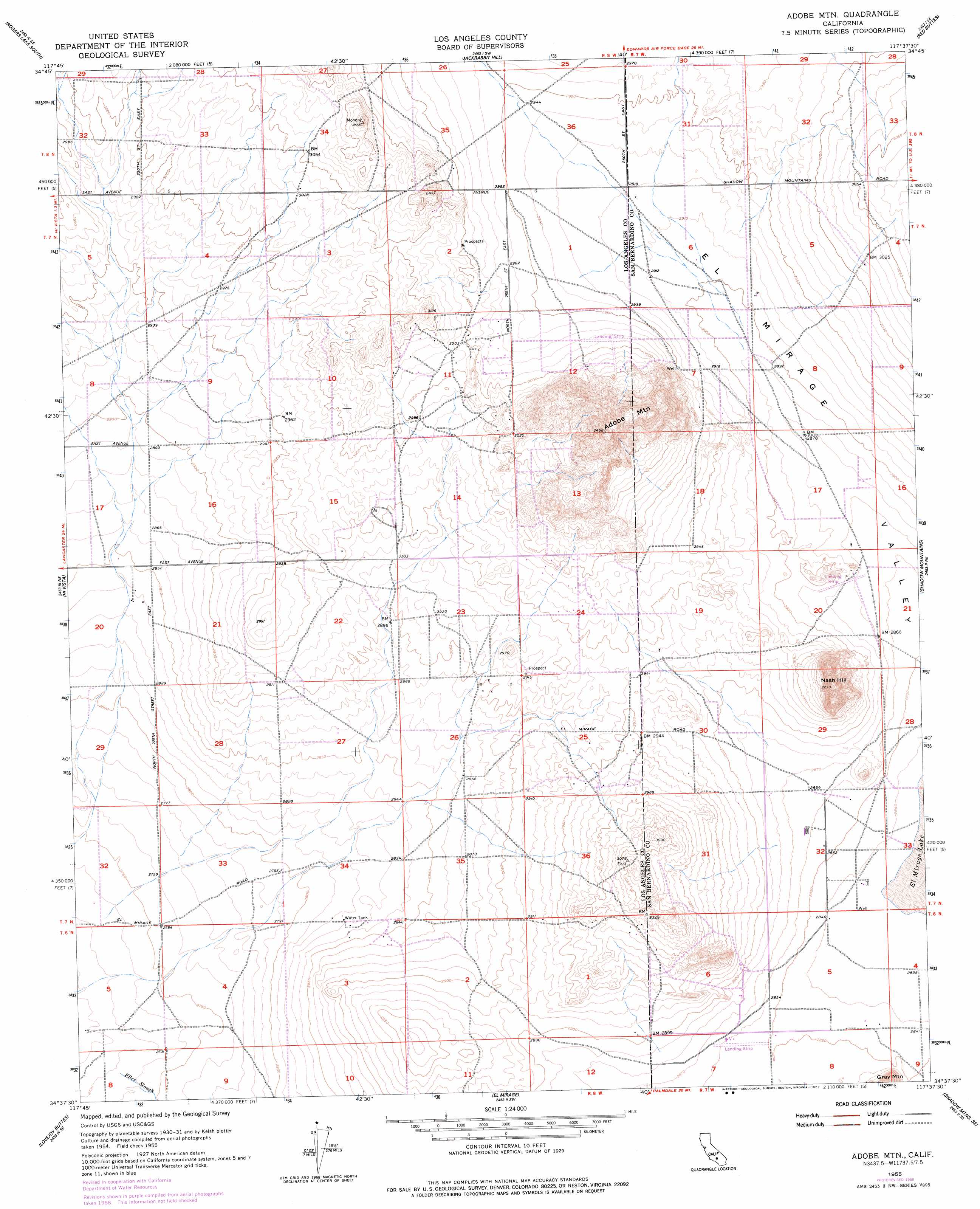
USGS Topo Quad 34117f6 - 1:24,000 scale
| Topo Map Name: | Adobe Mountain |
| USGS Topo Quad ID: | 34117f6 |
| Print Size: | ca. 21 1/4" wide x 27" high |
| Southeast Coordinates: | 34.625° N latitude / 117.625° W longitude |
| Map Center Coordinates: | 34.6875° N latitude / 117.6875° W longitude |
| U.S. State: | CA |
| Filename: | o34117f6.jpg |
| Download Map JPG Image: | Adobe Mountain topo map 1:24,000 scale |
| Map Type: | Topographic |
| Topo Series: | 7.5´ |
| Map Scale: | 1:24,000 |
| Source of Map Images: | United States Geological Survey (USGS) |
| Alternate Map Versions: |
Adobe Mtn. CA 1955, updated 1957 Download PDF Buy paper map Adobe Mtn CA 1955, updated 1965 Download PDF Buy paper map Adobe Mountain CA 1955, updated 1969 Download PDF Buy paper map Adobe Mtn CA 1955, updated 1969 Download PDF Buy paper map Adobe Mtn CA 1955, updated 1977 Download PDF Buy paper map Adobe Mountain CA 1955, updated 1993 Download PDF Buy paper map Adobe Mtn CA 1955, updated 1993 Download PDF Buy paper map Adobe Mountain CA 2012 Download PDF Buy paper map Adobe Mountain CA 2015 Download PDF Buy paper map |
1:24,000 Topo Quads surrounding Adobe Mountain
Edwards |
Rogers Lake North |
Leuhman Ridge |
Kramer Junction |
Kramer Hills |
Redman |
Rogers Lake South |
Jackrabbit Hill |
Red Buttes |
Astley Rancho |
Alpine Butte |
Hi Vista |
Adobe Mountain |
Shadow Mountains |
Victorville Nw |
Littlerock |
Lovejoy Buttes |
El Mirage |
Shadow Mountains Se |
Adelanto |
Juniper Hills |
Valyermo |
Mescal Creek |
Phelan |
Baldy Mesa |
> Back to 34117e1 at 1:100,000 scale
> Back to 34116a1 at 1:250,000 scale
> Back to U.S. Topo Maps home
Adobe Mountain topo map: Gazetteer
Adobe Mountain: Airports
Hansen Airport elevation 871m 2857′Adobe Mountain: Populated Places
Walton Place (historical) elevation 894m 2933′Adobe Mountain: Streams
Eller Slough elevation 834m 2736′Adobe Mountain: Summits
Adobe Mountain elevation 1018m 3339′Nash Hill elevation 993m 3257′
Adobe Mountain digital topo map on disk
Buy this Adobe Mountain topo map showing relief, roads, GPS coordinates and other geographical features, as a high-resolution digital map file on DVD: