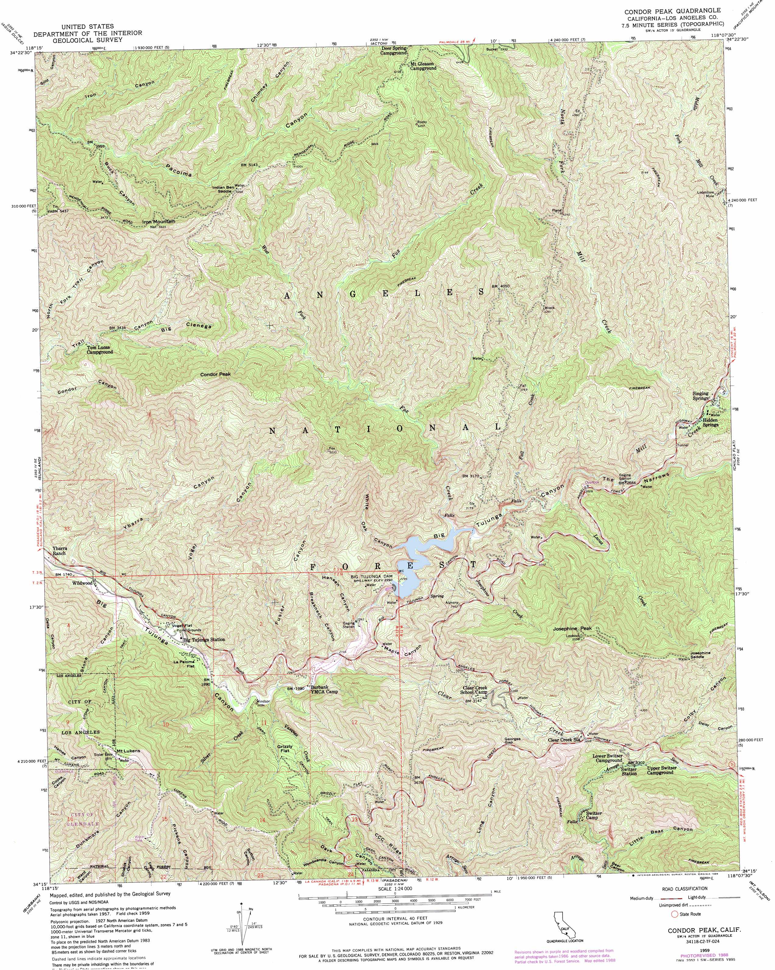
Condor Peak Topo Map California
To zoom in, hover over the map of Condor Peak
USGS Topo Quad 34118c2 - 1:24,000 scale
| Topo Map Name: | Condor Peak |
| USGS Topo Quad ID: | 34118c2 |
| Print Size: | ca. 21 1/4" wide x 27" high |
| Southeast Coordinates: | 34.25° N latitude / 118.125° W longitude |
| Map Center Coordinates: | 34.3125° N latitude / 118.1875° W longitude |
| U.S. State: | CA |
| Filename: | o34118c2.jpg |
| Download Map JPG Image: | Condor Peak topo map 1:24,000 scale |
| Map Type: | Topographic |
| Topo Series: | 7.5´ |
| Map Scale: | 1:24,000 |
| Source of Map Images: | United States Geological Survey (USGS) |
| Alternate Map Versions: |
Condor Peak CA 1959, updated 1959 Download PDF Buy paper map Condor Peak CA 1959, updated 1960 Download PDF Buy paper map Condor Peak CA 1959, updated 1965 Download PDF Buy paper map Condor Peak CA 1959, updated 1965 Download PDF Buy paper map Condor Peak CA 1959, updated 1976 Download PDF Buy paper map Condor Peak CA 1959, updated 1988 Download PDF Buy paper map Condor Peak CA 1959, updated 1994 Download PDF Buy paper map Condor Peak CA 1976 Download PDF Buy paper map Condor Peak CA 1995, updated 1999 Download PDF Buy paper map Condor Peak CA 2012 Download PDF Buy paper map Condor Peak CA 2015 Download PDF Buy paper map |
| FStopo: | US Forest Service topo Condor Peak is available: Download FStopo PDF Download FStopo TIF |
1:24,000 Topo Quads surrounding Condor Peak
Green Valley |
Sleepy Valley |
Ritter Ridge |
Palmdale |
Littlerock |
Mint Canyon |
Agua Dulce |
Acton |
Pacifico Mountain |
Juniper Hills |
San Fernando |
Sunland |
Condor Peak |
Chilao Flat |
Waterman Mountain |
Van Nuys |
Burbank |
Pasadena |
Mount Wilson |
Azusa |
Beverly Hills |
Hollywood |
Los Angeles |
El Monte |
Baldwin Park |
> Back to 34118a1 at 1:100,000 scale
> Back to 34118a1 at 1:250,000 scale
> Back to U.S. Topo Maps home
Condor Peak topo map: Gazetteer
Condor Peak: Dams
Big Tujunga Dam elevation 644m 2112′Big Tujunga Number 1 32-006 Dam elevation 691m 2267′
Condor Peak: Flats
Grizzly Flat elevation 804m 2637′La Paloma Flat elevation 589m 1932′
Vogel Flat elevation 580m 1902′
Condor Peak: Gaps
Georges Gap elevation 1102m 3615′Indian Ben Saddle elevation 1522m 4993′
Josephine Saddle elevation 1495m 4904′
Condor Peak: Mines
Lodestone Mine elevation 1197m 3927′Condor Peak: Populated Places
Hidden Springs elevation 954m 3129′Singing Springs elevation 968m 3175′
Wildwood elevation 535m 1755′
Condor Peak: Reservoirs
Big Tujunga Reservoir elevation 644m 2112′Condor Peak: Ridges
CCC Ridge elevation 901m 2956′Condor Peak: Streams
Clear Creek elevation 615m 2017′Fall Creek elevation 724m 2375′
Fox Creek elevation 708m 2322′
Josephine Creek elevation 711m 2332′
Lucas Creek elevation 743m 2437′
Mill Creek elevation 811m 2660′
North Fork Mill Creek elevation 933m 3061′
Silver Creek elevation 584m 1916′
Vasquez Creek elevation 593m 1945′
West Fork Fox Creek elevation 1076m 3530′
Condor Peak: Summits
Condor Peak elevation 1663m 5456′Hoyt Mountain elevation 1346m 4416′
Iron Mountain elevation 1710m 5610′
Josephine Peak elevation 1688m 5538′
Mount Lukens elevation 1544m 5065′
Condor Peak: Trails
Condor Peak Ridign and hiking Trail elevation 1265m 4150′Dark Canyon Trail elevation 893m 2929′
Stone Canyon Trail elevation 1006m 3300′
Condor Peak: Valleys
Bear Canyon elevation 786m 2578′Big Cienega elevation 1121m 3677′
Breakneck Canyon elevation 623m 2043′
Buck Canyon elevation 1219m 3999′
Chimney Canyon elevation 1392m 4566′
Colby Canyon elevation 1005m 3297′
Daisy Canyon elevation 1088m 3569′
Fusier Canyon elevation 592m 1942′
Hansen Canyon elevation 671m 2201′
Iron Canyon elevation 1182m 3877′
Little Bear Canyon elevation 800m 2624′
Long Canyon elevation 601m 1971′
Maple Canyon elevation 628m 2060′
North Fork Trail Canyon elevation 867m 2844′
Stone Canyon elevation 544m 1784′
The Narrows elevation 737m 2417′
Vogel Canyon elevation 554m 1817′
White Oak Canyon elevation 697m 2286′
Woodwardia Canyon elevation 681m 2234′
Ybarra Canyon elevation 521m 1709′
Condor Peak digital topo map on disk
Buy this Condor Peak topo map showing relief, roads, GPS coordinates and other geographical features, as a high-resolution digital map file on DVD: