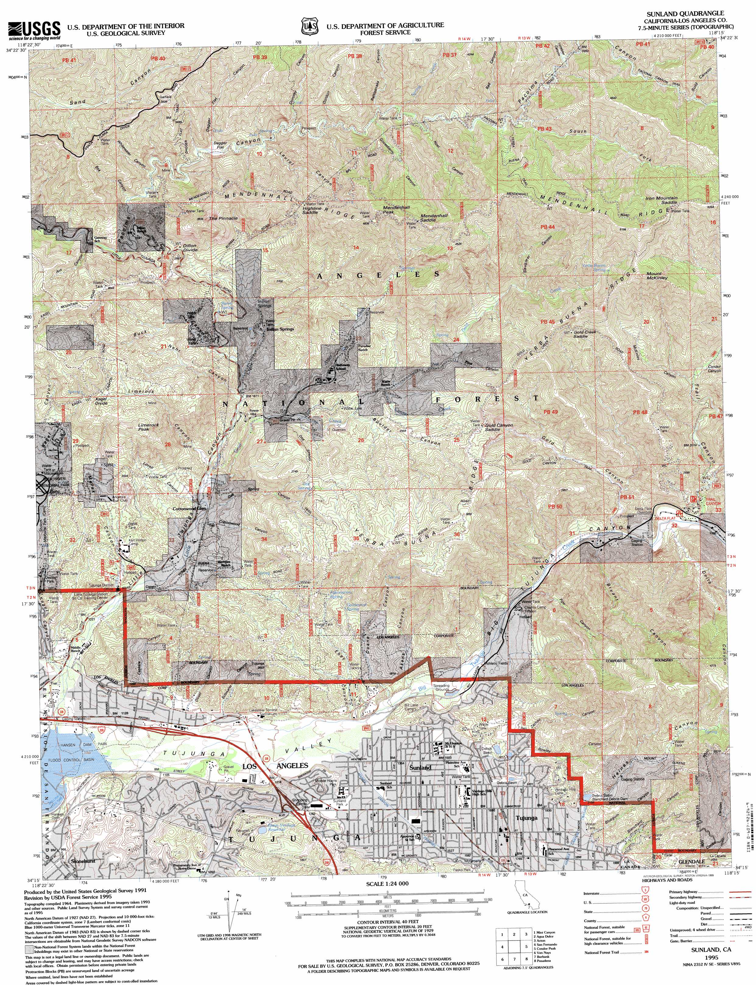
Sunland Topo Map California
To zoom in, hover over the map of Sunland
USGS Topo Quad 34118c3 - 1:24,000 scale
| Topo Map Name: | Sunland |
| USGS Topo Quad ID: | 34118c3 |
| Print Size: | ca. 21 1/4" wide x 27" high |
| Southeast Coordinates: | 34.25° N latitude / 118.25° W longitude |
| Map Center Coordinates: | 34.3125° N latitude / 118.3125° W longitude |
| U.S. State: | CA |
| Filename: | o34118c3.jpg |
| Download Map JPG Image: | Sunland topo map 1:24,000 scale |
| Map Type: | Topographic |
| Topo Series: | 7.5´ |
| Map Scale: | 1:24,000 |
| Source of Map Images: | United States Geological Survey (USGS) |
| Alternate Map Versions: |
Sunland CA 1953, updated 1954 Download PDF Buy paper map Sunland CA 1953, updated 1959 Download PDF Buy paper map Sunland CA 1966, updated 1967 Download PDF Buy paper map Sunland CA 1966, updated 1975 Download PDF Buy paper map Sunland CA 1966, updated 1988 Download PDF Buy paper map Sunland CA 1991, updated 1995 Download PDF Buy paper map Sunland CA 1995, updated 1999 Download PDF Buy paper map Sunland CA 2012 Download PDF Buy paper map Sunland CA 2015 Download PDF Buy paper map |
| FStopo: | US Forest Service topo Sunland is available: Download FStopo PDF Download FStopo TIF |
1:24,000 Topo Quads surrounding Sunland
Warm Springs Mountain |
Green Valley |
Sleepy Valley |
Ritter Ridge |
Palmdale |
Newhall |
Mint Canyon |
Agua Dulce |
Acton |
Pacifico Mountain |
Oat Mountain |
San Fernando |
Sunland |
Condor Peak |
Chilao Flat |
Canoga Park |
Van Nuys |
Burbank |
Pasadena |
Mount Wilson |
Topanga |
Beverly Hills |
Hollywood |
Los Angeles |
El Monte |
> Back to 34118a1 at 1:100,000 scale
> Back to 34118a1 at 1:250,000 scale
> Back to U.S. Topo Maps home
Sunland topo map: Gazetteer
Sunland: Airports
Camp 15 Heliport elevation 462m 1515′Sunland: Basins
Blanchard Debris Basin elevation 628m 2060′Haines Debris Basin elevation 665m 2181′
Sunland: Crossings
Exit 11 elevation 403m 1322′Exit 9 elevation 342m 1122′
Sunland: Dams
Blanchard Debris Dam elevation 628m 2060′Bluegum Canyon Debris Dam elevation 981m 3218′
Green Verdugo 6-043 Dam elevation 432m 1417′
Haines Canyon Debris Dam elevation 662m 2171′
Sunland: Flats
Dagger Flat elevation 746m 2447′Sunland: Gaps
Dillon Divide elevation 834m 2736′Gold Canyon Saddle elevation 921m 3021′
Gold Creek Saddle elevation 1137m 3730′
Highline Saddle elevation 1121m 3677′
Iron Mountain Saddle elevation 1521m 4990′
Kagel Divide elevation 810m 2657′
Mendenhall Saddle elevation 1331m 4366′
Sunland: Lakes
Redwing Lake elevation 310m 1017′Sunland: Parks
Dexter Park elevation 436m 1430′Lakeview Terrace Recreation Center elevation 331m 1085′
Little Landers Park elevation 546m 1791′
McGroarty Park elevation 488m 1601′
Orcas Park elevation 324m 1062′
Sunland Park elevation 406m 1332′
Sunland: Populated Places
Indian Springs elevation 597m 1958′Lake View Terrace elevation 357m 1171′
Shadow Hills elevation 362m 1187′
Stonehurst elevation 290m 951′
Sunland elevation 461m 1512′
Tujunga elevation 540m 1771′
Sunland: Post Offices
Sunland Post Office elevation 404m 1325′Tujunga Post Office elevation 517m 1696′
Sunland: Reservoirs
Green Verdugo Reservoir elevation 432m 1417′Sunland: Ridges
Mendenhall Ridge elevation 1454m 4770′Yerba Buena Ridge elevation 1026m 3366′
Sunland: Springs
Barrel Spring elevation 670m 2198′Fascination Spring elevation 646m 2119′
Goldenrod Spring elevation 608m 1994′
Indian Springs elevation 621m 2037′
Oak Spring elevation 786m 2578′
Yerba Buena Spring elevation 1198m 3930′
Sunland: Streams
Alder Creek elevation 545m 1788′Big Tujunga Creek elevation 326m 1069′
Center Creek elevation 654m 2145′
Gold Creek elevation 441m 1446′
Little Tujunga Creek elevation 327m 1072′
Spring Creek elevation 902m 2959′
Sunland: Summits
Limerock Peak elevation 905m 2969′Mendenhall Peak elevation 1374m 4507′
Mount McKinley elevation 1497m 4911′
The Pinnacle elevation 1094m 3589′
Sunland: Trails
Dagger Flat Trail elevation 1018m 3339′Gold Canyon Trail elevation 615m 2017′
Oak Spring Trail elevation 767m 2516′
Yerba Buena Trail elevation 1083m 3553′
Sunland: Valleys
Akens Canyon elevation 395m 1295′Ant Canyon elevation 647m 2122′
Bad Canyon elevation 928m 3044′
Bee Canyon elevation 677m 2221′
Big Tujunga Canyon elevation 396m 1299′
Blanchard Canyon elevation 619m 2030′
Bluegum Canyon elevation 607m 1991′
Boulder Canyon elevation 636m 2086′
Bryant Canyon elevation 482m 1581′
Buck Canyon elevation 542m 1778′
Cassara Canyon elevation 384m 1259′
Condor Canyon elevation 807m 2647′
Cottonwood Canyon elevation 431m 1414′
Crescenta Valley elevation 337m 1105′
Dagger Flat Canyon elevation 739m 2424′
Delta Canyon elevation 835m 2739′
Doane Canyon elevation 395m 1295′
Dorothy Canyon elevation 799m 2621′
Ebey Canyon elevation 387m 1269′
Gold Canyon elevation 482m 1581′
Gooseberry Canyon elevation 861m 2824′
Gordon Canyon elevation 825m 2706′
Haines Canyon elevation 641m 2103′
Laurel Canyon elevation 780m 2559′
Limerock Canyon elevation 474m 1555′
Little Tujunga Canyon elevation 327m 1072′
Lonetree Canyon elevation 1021m 3349′
Lovell Canyon elevation 437m 1433′
Marek Canyon elevation 380m 1246′
McKinley Canyon elevation 764m 2506′
Nehr Canyon elevation 512m 1679′
Noel Canyon elevation 903m 2962′
Oak Spring Canyon elevation 443m 1453′
Oliver Canyon elevation 366m 1200′
Pine Canyon elevation 728m 2388′
Pipe Canyon elevation 459m 1505′
Rattlesnake Canyon elevation 895m 2936′
Rowley Canyon elevation 571m 1873′
Schwartz Canyon elevation 392m 1286′
Slaughter Canyon elevation 891m 2923′
Sold Canyon elevation 1139m 3736′
South Fork Pacoima Canyon elevation 963m 3159′
Trail Canyon elevation 511m 1676′
Tujunga Valley elevation 325m 1066′
Whitewater Canyon elevation 717m 2352′
Zachau Canyon elevation 558m 1830′
Sunland digital topo map on disk
Buy this Sunland topo map showing relief, roads, GPS coordinates and other geographical features, as a high-resolution digital map file on DVD: