Whitaker Peak Topo Map California
To zoom in, hover over the map of Whitaker Peak
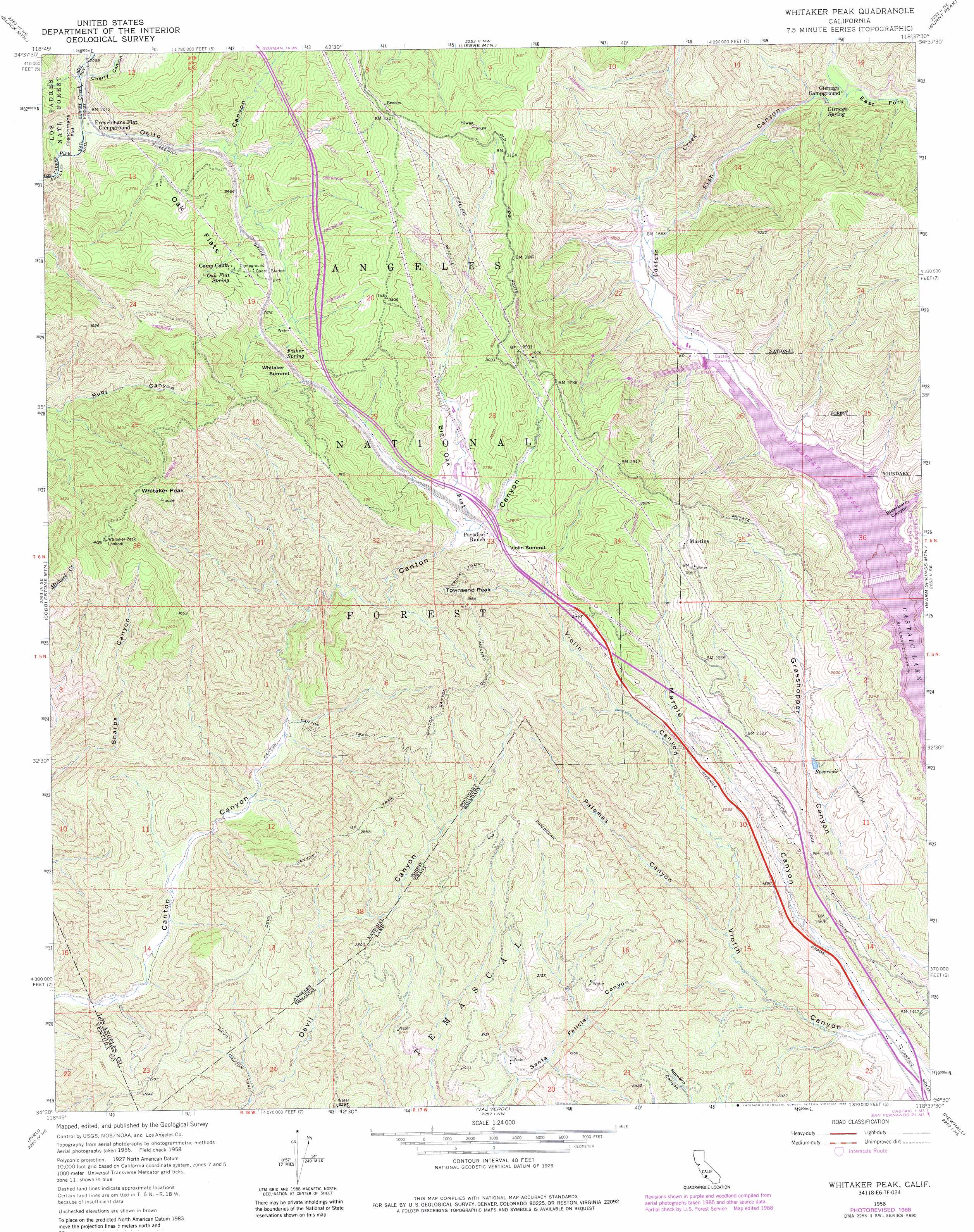
USGS Topo Quad 34118e6 - 1:24,000 scale
| Topo Map Name: | Whitaker Peak |
| USGS Topo Quad ID: | 34118e6 |
| Print Size: | ca. 21 1/4" wide x 27" high |
| Southeast Coordinates: | 34.5° N latitude / 118.625° W longitude |
| Map Center Coordinates: | 34.5625° N latitude / 118.6875° W longitude |
| U.S. State: | CA |
| Filename: | o34118e6.jpg |
| Download Map JPG Image: | Whitaker Peak topo map 1:24,000 scale |
| Map Type: | Topographic |
| Topo Series: | 7.5´ |
| Map Scale: | 1:24,000 |
| Source of Map Images: | United States Geological Survey (USGS) |
| Alternate Map Versions: |
Whitaker Peak CA 1958, updated 1959 Download PDF Buy paper map Whitaker Peak CA 1958, updated 1963 Download PDF Buy paper map Whitaker Peak CA 1958, updated 1963 Download PDF Buy paper map Whitaker Peak CA 1958, updated 1976 Download PDF Buy paper map Whitaker Peak CA 1958, updated 1988 Download PDF Buy paper map Whitaker Peak CA 1995, updated 1999 Download PDF Buy paper map Whitaker Peak CA 2012 Download PDF Buy paper map Whitaker Peak CA 2015 Download PDF Buy paper map |
| FStopo: | US Forest Service topo Whitaker Peak is available: Download FStopo PDF Download FStopo TIF |
1:24,000 Topo Quads surrounding Whitaker Peak
Frazier Mountain |
Lebec |
La Liebre Ranch |
Neenach School |
Fairmont Butte |
Alamo Mountain |
Black Mountain |
Liebre Mountain |
Burnt Peak |
Lake Hughes |
Devils Heart Peak |
Cobblestone Mountain |
Whitaker Peak |
Warm Springs Mountain |
Green Valley |
Fillmore |
Piru |
Val Verde |
Newhall |
Mint Canyon |
Moorpark |
Simi Valley West |
Simi Valley East |
Oat Mountain |
San Fernando |
> Back to 34118e1 at 1:100,000 scale
> Back to 34118a1 at 1:250,000 scale
> Back to U.S. Topo Maps home
Whitaker Peak topo map: Gazetteer
Whitaker Peak: Canals
Tailrace Canal elevation 463m 1519′Whitaker Peak: Dams
Elderberry Forebay 6-049 Dam elevation 420m 1377′Whitaker Peak: Flats
Big Oak Flat elevation 779m 2555′Frenchmans Flat elevation 649m 2129′
Oak Flats elevation 862m 2828′
Whitaker Peak: Gaps
Violin Summit elevation 789m 2588′Whitaker Summit elevation 904m 2965′
Whitaker Peak: Populated Places
Martins elevation 828m 2716′Naylor Place elevation 499m 1637′
Whitaker Peak: Reservoirs
Elderberry Forebay elevation 463m 1519′Elderberry Lake elevation 420m 1377′
Whitaker Peak: Springs
Cienaga Spring elevation 611m 2004′Fisher Spring elevation 840m 2755′
Oak Flat Spring elevation 866m 2841′
Whitaker Peak: Summits
Townsend Peak elevation 961m 3152′Whitaker Peak elevation 1262m 4140′
Whitaker Peak: Trails
Canton Canyon Devil Canyon Truck Trail elevation 903m 2962′Canton Canyon Trail elevation 642m 2106′
Devil Canyon Trail elevation 764m 2506′
Whitaker Peak: Valleys
Cherry Canyon elevation 634m 2080′East Fork Fish Canyon elevation 617m 2024′
Elderberry Canyon elevation 463m 1519′
Fish Canyon elevation 494m 1620′
Osito Canyon elevation 621m 2037′
Palomas Canyon elevation 448m 1469′
Redrock Canyon elevation 593m 1945′
Violin Canyon elevation 390m 1279′
Whitaker Peak digital topo map on disk
Buy this Whitaker Peak topo map showing relief, roads, GPS coordinates and other geographical features, as a high-resolution digital map file on DVD: