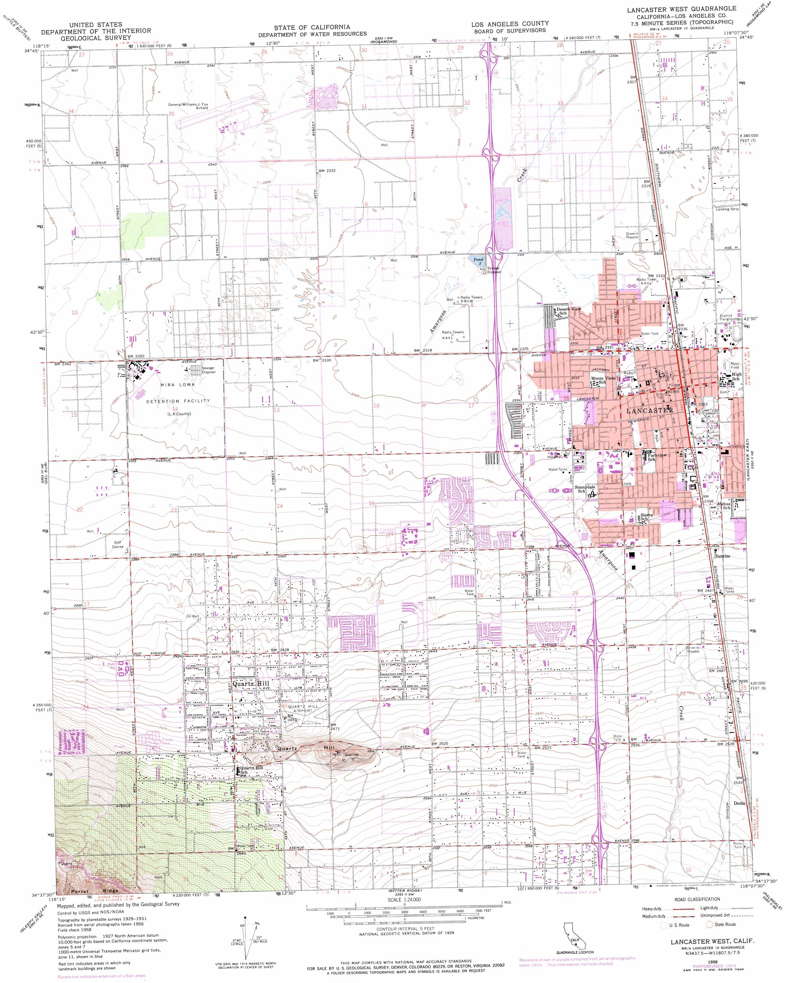
Lancaster West Topo Map California
To zoom in, hover over the map of Lancaster West
USGS Topo Quad 34118f2 - 1:24,000 scale
| Topo Map Name: | Lancaster West |
| USGS Topo Quad ID: | 34118f2 |
| Print Size: | ca. 21 1/4" wide x 27" high |
| Southeast Coordinates: | 34.625° N latitude / 118.125° W longitude |
| Map Center Coordinates: | 34.6875° N latitude / 118.1875° W longitude |
| U.S. State: | CA |
| Filename: | o34118f2.jpg |
| Download Map JPG Image: | Lancaster West topo map 1:24,000 scale |
| Map Type: | Topographic |
| Topo Series: | 7.5´ |
| Map Scale: | 1:24,000 |
| Source of Map Images: | United States Geological Survey (USGS) |
| Alternate Map Versions: |
Lancaster West CA 1958, updated 1959 Download PDF Buy paper map Lancaster West CA 1958, updated 1966 Download PDF Buy paper map Lancaster West CA 1958, updated 1975 Download PDF Buy paper map Lancaster West CA 1958, updated 1975 Download PDF Buy paper map Lancaster West CA 2012 Download PDF Buy paper map Lancaster West CA 2015 Download PDF Buy paper map |
1:24,000 Topo Quads surrounding Lancaster West
Tylerhorse Canyon |
Willow Springs |
Soledad Mountain |
Bissell |
Edwards |
Fairmont Butte |
Little Buttes |
Rosamond |
Rosamond Lake |
Redman |
Lake Hughes |
Del Sur |
Lancaster West |
Lancaster East |
Alpine Butte |
Green Valley |
Sleepy Valley |
Ritter Ridge |
Palmdale |
Littlerock |
Mint Canyon |
Agua Dulce |
Acton |
Pacifico Mountain |
Juniper Hills |
> Back to 34118e1 at 1:100,000 scale
> Back to 34118a1 at 1:250,000 scale
> Back to U.S. Topo Maps home
Lancaster West topo map: Gazetteer
Lancaster West: Airports
Antelope Valley Service Center Heliport elevation 768m 2519′General William J Fox Airfield elevation 715m 2345′
Quartz Hill Airport (historical) elevation 748m 2454′
Lancaster West: Crossings
Exit 39 elevation 790m 2591′Exit 40 elevation 769m 2522′
Exit 41 elevation 749m 2457′
Exit 42 elevation 730m 2395′
Exit 43 elevation 714m 2342′
Exit 44 elevation 709m 2326′
Exit 45 elevation 706m 2316′
Exit 46 elevation 706m 2316′
Exit 47 elevation 706m 2316′
Lancaster West: Parks
Antelope Valley Fairgrounds elevation 716m 2349′Apollo Park elevation 710m 2329′
George Lane Park elevation 749m 2457′
Hull Park elevation 715m 2345′
Jane Reynolds Park elevation 723m 2372′
Kleiner Park elevation 745m 2444′
Marauder Stadium elevation 726m 2381′
Mariposa Park elevation 709m 2326′
Mays Field elevation 719m 2358′
Rawley Duntley Park elevation 729m 2391′
Lancaster West: Populated Places
Lancaster elevation 719m 2358′Quartz Hill elevation 761m 2496′
Sierra Villa Mobile Home Park elevation 705m 2312′
Sunrise elevation 742m 2434′
Lancaster West: Post Offices
Lancaster Post Office elevation 722m 2368′Quartz Hill Post Office elevation 757m 2483′
Lancaster West: Reservoirs
Pond Two elevation 706m 2316′Lancaster West: Ridges
Quartz Hill elevation 777m 2549′Lancaster West digital topo map on disk
Buy this Lancaster West topo map showing relief, roads, GPS coordinates and other geographical features, as a high-resolution digital map file on DVD: