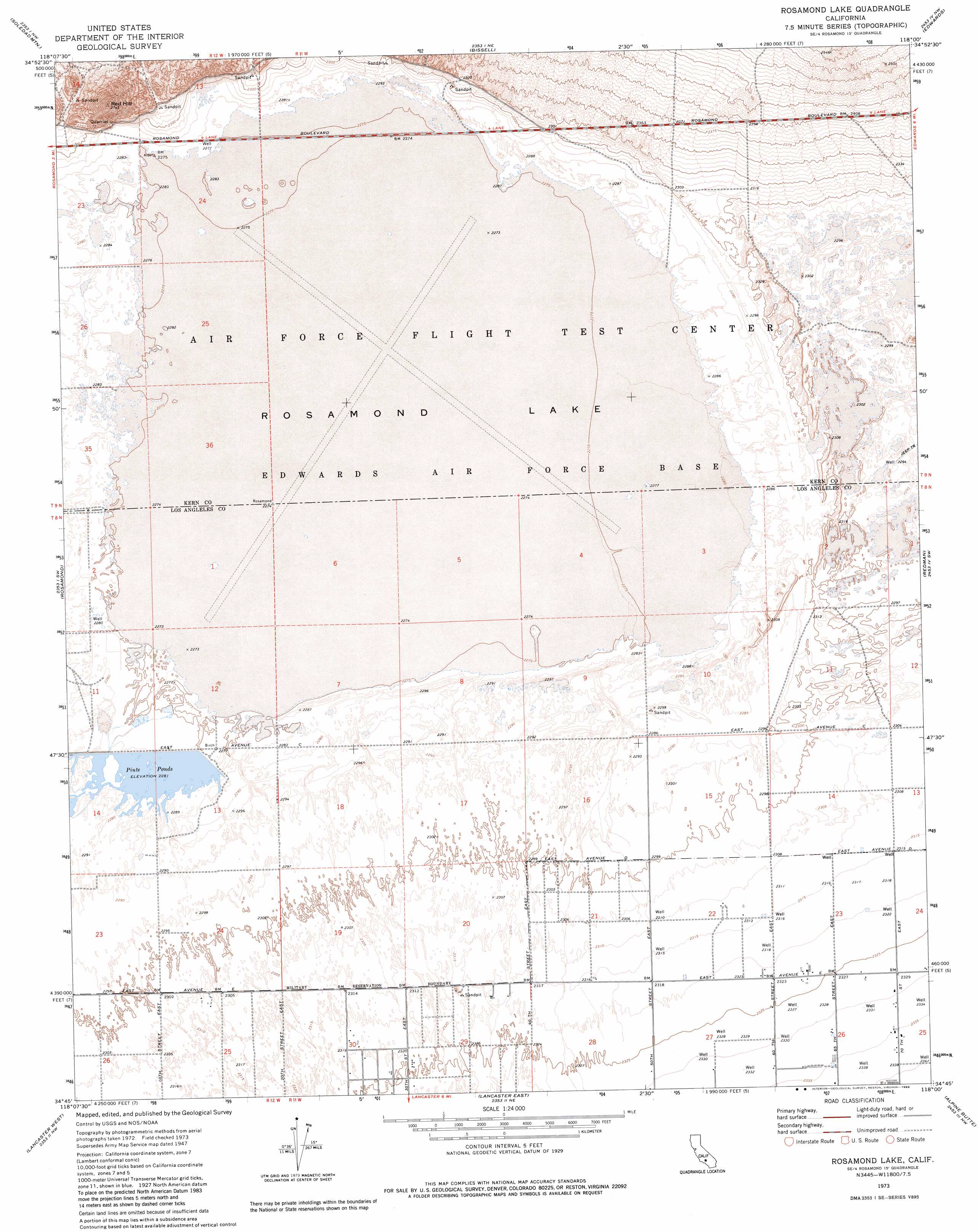
Rosamond Lake Topo Map California
To zoom in, hover over the map of Rosamond Lake
USGS Topo Quad 34118g1 - 1:24,000 scale
| Topo Map Name: | Rosamond Lake |
| USGS Topo Quad ID: | 34118g1 |
| Print Size: | ca. 21 1/4" wide x 27" high |
| Southeast Coordinates: | 34.75° N latitude / 118° W longitude |
| Map Center Coordinates: | 34.8125° N latitude / 118.0625° W longitude |
| U.S. State: | CA |
| Filename: | o34118g1.jpg |
| Download Map JPG Image: | Rosamond Lake topo map 1:24,000 scale |
| Map Type: | Topographic |
| Topo Series: | 7.5´ |
| Map Scale: | 1:24,000 |
| Source of Map Images: | United States Geological Survey (USGS) |
| Alternate Map Versions: |
Rosamond Lake CA 1947, updated 1964 Download PDF Buy paper map Rosamond Lake CA 1973, updated 1976 Download PDF Buy paper map Rosamond Lake CA 1973, updated 1983 Download PDF Buy paper map Rosamond Lake CA 2012 Download PDF Buy paper map Rosamond Lake CA 2015 Download PDF Buy paper map |
1:24,000 Topo Quads surrounding Rosamond Lake
Monolith |
Mojave |
Sanborn |
California City South |
North Edwards |
Willow Springs |
Soledad Mountain |
Bissell |
Edwards |
Rogers Lake North |
Little Buttes |
Rosamond |
Rosamond Lake |
Redman |
Rogers Lake South |
Del Sur |
Lancaster West |
Lancaster East |
Alpine Butte |
Hi Vista |
Sleepy Valley |
Ritter Ridge |
Palmdale |
Littlerock |
Lovejoy Buttes |
> Back to 34118e1 at 1:100,000 scale
> Back to 34118a1 at 1:250,000 scale
> Back to U.S. Topo Maps home
Rosamond Lake topo map: Gazetteer
Rosamond Lake: Flats
Rosamond Lake elevation 694m 2276′Rosamond Lake: Mines
Rosamond Sand Pits elevation 696m 2283′Rosamond Lake: Reservoirs
Piute Ponds elevation 696m 2283′Rosamond Lake: Summits
Red Hill elevation 828m 2716′Rosamond Lake digital topo map on disk
Buy this Rosamond Lake topo map showing relief, roads, GPS coordinates and other geographical features, as a high-resolution digital map file on DVD: