White Ledge Peak Topo Map California
To zoom in, hover over the map of White Ledge Peak
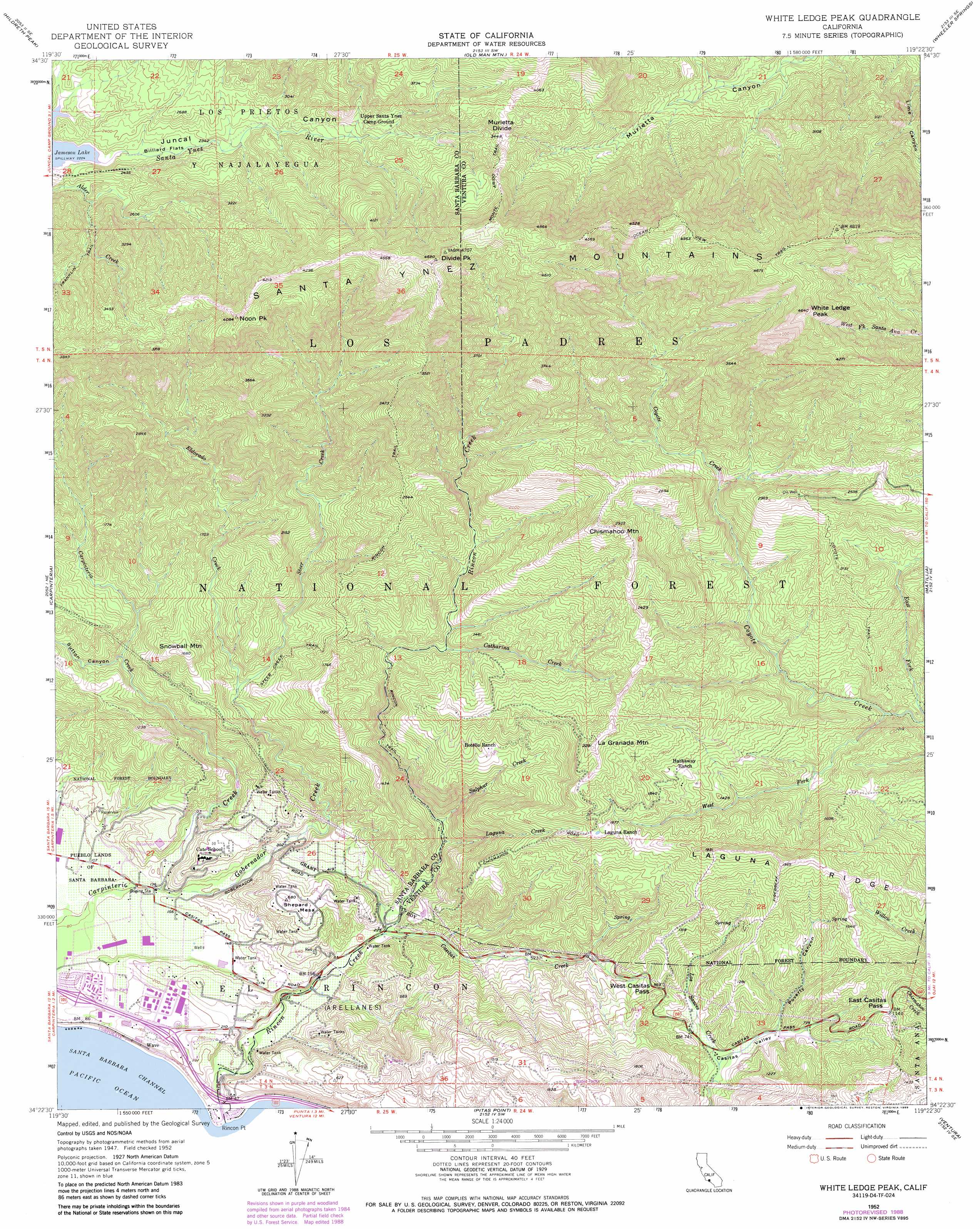
USGS Topo Quad 34119d4 - 1:24,000 scale
| Topo Map Name: | White Ledge Peak |
| USGS Topo Quad ID: | 34119d4 |
| Print Size: | ca. 21 1/4" wide x 27" high |
| Southeast Coordinates: | 34.375° N latitude / 119.375° W longitude |
| Map Center Coordinates: | 34.4375° N latitude / 119.4375° W longitude |
| U.S. State: | CA |
| Filename: | o34119d4.jpg |
| Download Map JPG Image: | White Ledge Peak topo map 1:24,000 scale |
| Map Type: | Topographic |
| Topo Series: | 7.5´ |
| Map Scale: | 1:24,000 |
| Source of Map Images: | United States Geological Survey (USGS) |
| Alternate Map Versions: |
White Ledge Peak CA 1952, updated 1953 Download PDF Buy paper map White Ledge Peak CA 1952, updated 1962 Download PDF Buy paper map White Ledge Peak CA 1952, updated 1968 Download PDF Buy paper map White Ledge Peak CA 1952, updated 1975 Download PDF Buy paper map White Ledge Peak CA 1952, updated 1989 Download PDF Buy paper map White Ledge Peak CA 1995, updated 2000 Download PDF Buy paper map White Ledge Peak CA 2012 Download PDF Buy paper map White Ledge Peak CA 2015 Download PDF Buy paper map |
| FStopo: | US Forest Service topo White Ledge Peak is available: Download FStopo PDF Download FStopo TIF |
1:24,000 Topo Quads surrounding White Ledge Peak
Big Pine Mountain |
Madulce Peak |
Rancho Nuevo Creek |
Reyes Peak |
San Guillermo |
Little Pine Mountain |
Hildreth Peak |
Old Man Mountain |
Wheeler Springs |
Lion Canyon |
Santa Barbara |
Carpinteria |
White Ledge Peak |
Matilija |
Ojai |
Pitas Point |
Ventura |
Saticoy |
||
Oxnard |
> Back to 34119a1 at 1:100,000 scale
> Back to 34118a1 at 1:250,000 scale
> Back to U.S. Topo Maps home
White Ledge Peak topo map: Gazetteer
White Ledge Peak: Areas
Rincon Firebreak elevation 667m 2188′White Ledge Peak: Dams
Carpinteria Dam elevation 115m 377′White Ledge Peak: Flats
Billiard Flats elevation 697m 2286′White Ledge Peak: Gaps
East Casitas Pass elevation 353m 1158′Murietta Divide elevation 1040m 3412′
West Casitas Pass elevation 312m 1023′
White Ledge Peak: Parks
Lions Club Park elevation 37m 121′Monte Vista Park elevation 40m 131′
Rincon Beach County Park elevation 7m 22′
White Ledge Peak: Populated Places
Shepards elevation 82m 269′Vista de Santa Barbara Mobile Homes elevation 49m 160′
White Ledge Peak: Reservoirs
Carpinteria Reservoir elevation 115m 377′Murietta Dam elevation 1231m 4038′
White Ledge Peak: Ridges
Laguna Ridge elevation 597m 1958′Superior Ridge elevation 774m 2539′
White Ledge Peak: Streams
Casitas Creek elevation 64m 209′Catharina Creek elevation 341m 1118′
East Fork Coyote Creek elevation 207m 679′
Eldorado Creek elevation 259m 849′
Gobernador Creek elevation 43m 141′
Laguna Creek elevation 128m 419′
Steer Creek elevation 259m 849′
Sulphur Creek elevation 152m 498′
Sutton Creek elevation 259m 849′
West Fork Coyote Creek elevation 222m 728′
White Ledge Peak: Summits
Chismahoo Mountain elevation 891m 2923′Divide Peak elevation 1384m 4540′
La Granada Mountain elevation 686m 2250′
Noon Peak elevation 1212m 3976′
Shephard Mesa elevation 208m 682′
Snowball Mountain elevation 513m 1683′
White Ledge Peak elevation 1396m 4580′
White Ledge Peak: Trails
Coyote Trail elevation 413m 1354′Coyote Trail elevation 458m 1502′
Monte Arido Trail elevation 1110m 3641′
Ocean View Trail elevation 1407m 4616′
Rincon Trail elevation 742m 2434′
Steer Creek Trail elevation 356m 1167′
White Ledge Peak: Valleys
Casitas Valley elevation 255m 836′Juncal Canyon elevation 682m 2237′
Poverty Canyon elevation 220m 721′
Sutton Canyon elevation 259m 849′
White Ledge Peak digital topo map on disk
Buy this White Ledge Peak topo map showing relief, roads, GPS coordinates and other geographical features, as a high-resolution digital map file on DVD: