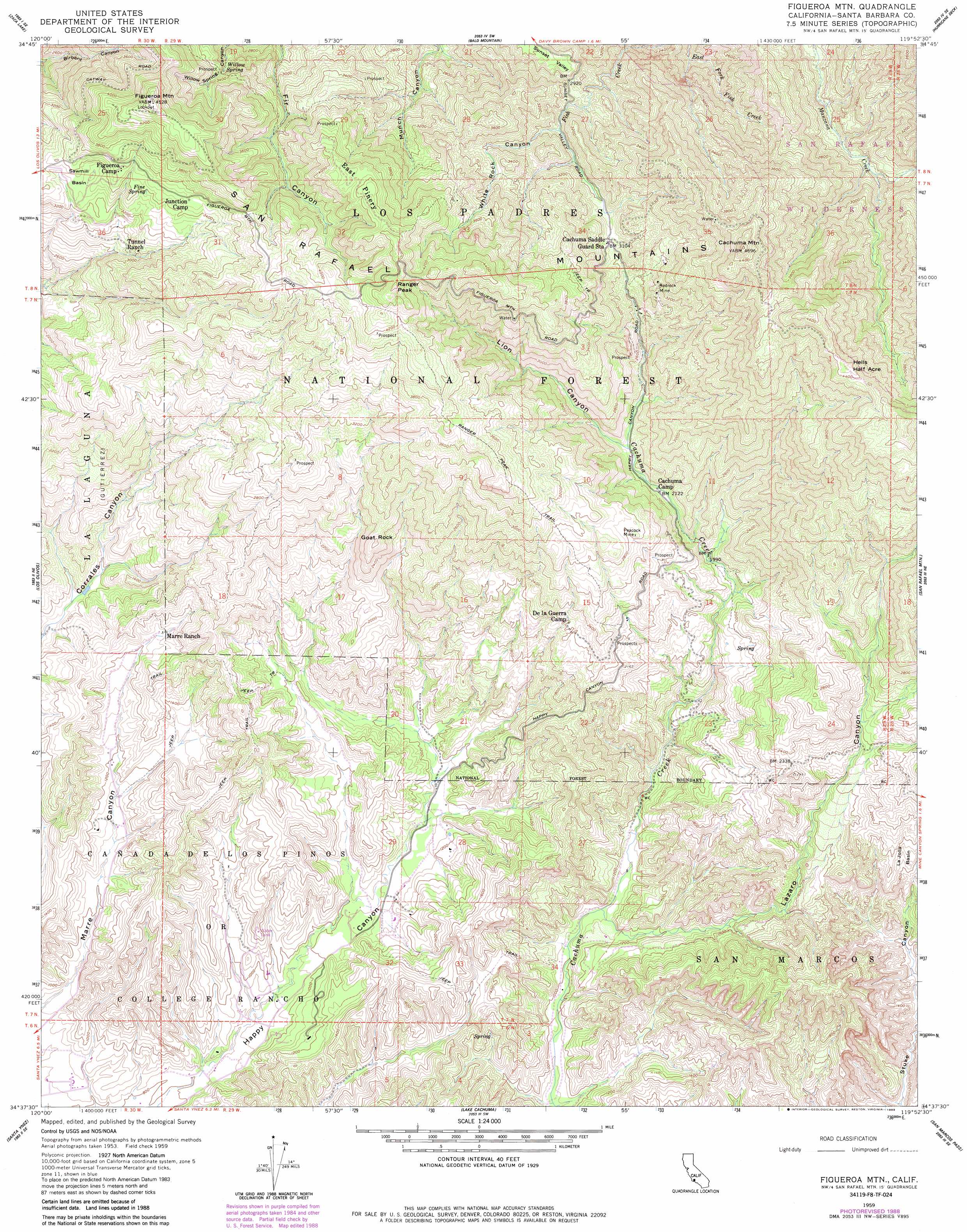
Figueroa Mountain Topo Map California
To zoom in, hover over the map of Figueroa Mountain
USGS Topo Quad 34119f8 - 1:24,000 scale
| Topo Map Name: | Figueroa Mountain |
| USGS Topo Quad ID: | 34119f8 |
| Print Size: | ca. 21 1/4" wide x 27" high |
| Southeast Coordinates: | 34.625° N latitude / 119.875° W longitude |
| Map Center Coordinates: | 34.6875° N latitude / 119.9375° W longitude |
| U.S. State: | CA |
| Filename: | o34119f8.jpg |
| Download Map JPG Image: | Figueroa Mountain topo map 1:24,000 scale |
| Map Type: | Topographic |
| Topo Series: | 7.5´ |
| Map Scale: | 1:24,000 |
| Source of Map Images: | United States Geological Survey (USGS) |
| Alternate Map Versions: |
Figueroa Mtn CA 1959, updated 1960 Download PDF Buy paper map Figueroa Mtn CA 1959, updated 1965 Download PDF Buy paper map Figueroa Mtn CA 1959, updated 1984 Download PDF Buy paper map Figueroa Mtn CA 1959, updated 1989 Download PDF Buy paper map Figueroa Mountain CA 1995, updated 2000 Download PDF Buy paper map Figueroa Mountain CA 2012 Download PDF Buy paper map Figueroa Mountain CA 2015 Download PDF Buy paper map |
| FStopo: | US Forest Service topo Figueroa Mountain is available: Download FStopo PDF Download FStopo TIF |
1:24,000 Topo Quads surrounding Figueroa Mountain
Tepusquet Canyon |
Manzanita Mountain |
Bates Canyon |
Peak Mountain |
New Cuyama |
Foxen Canyon |
Zaca Lake |
Bald Mountain |
Hurricane Deck |
Salisbury Potrero |
Zaca Creek |
Los Olivos |
Figueroa Mountain |
San Rafael Mountain |
Big Pine Mountain |
Solvang |
Santa Ynez |
Lake Cachuma |
San Marcos Pass |
Little Pine Mountain |
Gaviota |
Tajiguas |
Dos Pueblos Canyon |
Goleta |
Santa Barbara |
> Back to 34119e1 at 1:100,000 scale
> Back to 34118a1 at 1:250,000 scale
> Back to U.S. Topo Maps home
Figueroa Mountain topo map: Gazetteer
Figueroa Mountain: Basins
Sawmill Basin elevation 1000m 3280′Figueroa Mountain: Benches
Hells Half Acre elevation 1366m 4481′Figueroa Mountain: Mines
Peacock Mine elevation 866m 2841′Redrock Mine elevation 959m 3146′
Figueroa Mountain: Populated Places
Junction Camp elevation 1065m 3494′Figueroa Mountain: Springs
Chicken Springs elevation 681m 2234′Fine Spring elevation 1040m 3412′
Soldiers Home Spring elevation 973m 3192′
Willow Spring elevation 991m 3251′
Figueroa Mountain: Summits
Cachuma Mountain elevation 1409m 4622′Figueroa Mountain elevation 1378m 4520′
Goat Rock elevation 838m 2749′
Ranger Peak elevation 1376m 4514′
Figueroa Mountain: Trails
Ranger Peak Trail elevation 1136m 3727′Figueroa Mountain: Valleys
Lazaro Canyon elevation 323m 1059′Lion Canyon elevation 682m 2237′
White Rock Canyon elevation 888m 2913′
Figueroa Mountain: Woods
East Pinery elevation 1258m 4127′Figueroa Mountain digital topo map on disk
Buy this Figueroa Mountain topo map showing relief, roads, GPS coordinates and other geographical features, as a high-resolution digital map file on DVD: