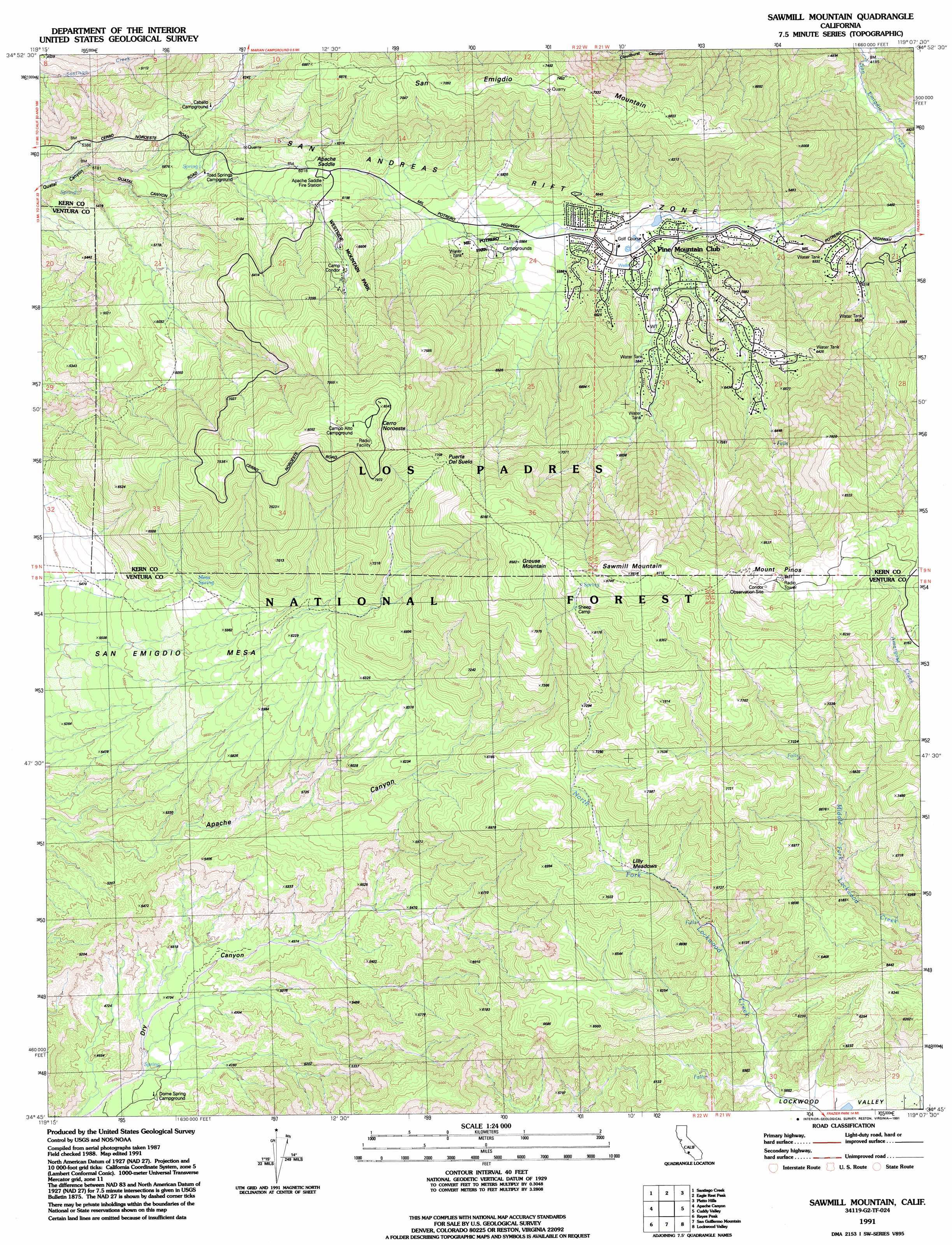
Sawmill Mountain Topo Map California
To zoom in, hover over the map of Sawmill Mountain
USGS Topo Quad 34119g2 - 1:24,000 scale
| Topo Map Name: | Sawmill Mountain |
| USGS Topo Quad ID: | 34119g2 |
| Print Size: | ca. 21 1/4" wide x 27" high |
| Southeast Coordinates: | 34.75° N latitude / 119.125° W longitude |
| Map Center Coordinates: | 34.8125° N latitude / 119.1875° W longitude |
| U.S. State: | CA |
| Filename: | o34119g2.jpg |
| Download Map JPG Image: | Sawmill Mountain topo map 1:24,000 scale |
| Map Type: | Topographic |
| Topo Series: | 7.5´ |
| Map Scale: | 1:24,000 |
| Source of Map Images: | United States Geological Survey (USGS) |
| Alternate Map Versions: |
Sawmill Mountain CA 1943, updated 1959 Download PDF Buy paper map Sawmill Mountain CA 1943, updated 1967 Download PDF Buy paper map Sawmill Mountain CA 1943, updated 1977 Download PDF Buy paper map Sawmill Mountain CA 1943, updated 1985 Download PDF Buy paper map Sawmill Mountain CA 1991, updated 1991 Download PDF Buy paper map Sawmill Mountain CA 1991, updated 1991 Download PDF Buy paper map Sawmill Mountain CA 1995, updated 2000 Download PDF Buy paper map Sawmill Mountain CA 2012 Download PDF Buy paper map Sawmill Mountain CA 2015 Download PDF Buy paper map |
| FStopo: | US Forest Service topo Sawmill Mountain is available: Download FStopo PDF Download FStopo TIF |
1:24,000 Topo Quads surrounding Sawmill Mountain
Maricopa |
Pentland |
Conner Sw |
Coal Oil Canyon |
Mettler |
Ballinger Canyon |
Santiago Creek |
Eagle Rest Peak |
Pleito Hills |
Grapevine |
Cuyama Peak |
Apache Canyon |
Sawmill Mountain |
Cuddy Valley |
Frazier Mountain |
Rancho Nuevo Creek |
Reyes Peak |
San Guillermo |
Lockwood Valley |
Alamo Mountain |
Old Man Mountain |
Wheeler Springs |
Lion Canyon |
Topatopa Mountains |
Devils Heart Peak |
> Back to 34119e1 at 1:100,000 scale
> Back to 34118a1 at 1:250,000 scale
> Back to U.S. Topo Maps home
Sawmill Mountain topo map: Gazetteer
Sawmill Mountain: Benches
San Emigdio Mesa elevation 1708m 5603′Sawmill Mountain: Flats
Lilly Meadows elevation 1999m 6558′Sawmill Mountain: Gaps
Apache Saddle elevation 1859m 6099′Puerta del Suelo elevation 2341m 7680′
Sawmill Mountain: Parks
Mil Potrero Park elevation 1717m 5633′Westside Mountain Park elevation 1996m 6548′
Sawmill Mountain: Populated Places
Pine Mountain Club elevation 1723m 5652′Sawmill Mountain: Ranges
San Emigdio Mountains elevation 2282m 7486′Sawmill Mountain: Ridges
Tecuya Ridge elevation 1992m 6535′Sawmill Mountain: Springs
Mesa Spring elevation 1903m 6243′Mesa Spring elevation 1821m 5974′
Sawmill Mountain: Summits
Cerro Noroeste elevation 2525m 8284′Grouse Mountain elevation 2613m 8572′
Mount Pinos elevation 2686m 8812′
San Emigdio Mountain elevation 2282m 7486′
Sawmill Mountain elevation 2684m 8805′
Sawmill Mountain: Swamps
Mill Potrero (historical) elevation 1642m 5387′Sawmill Mountain digital topo map on disk
Buy this Sawmill Mountain topo map showing relief, roads, GPS coordinates and other geographical features, as a high-resolution digital map file on DVD: