Los Alamos Topo Map California
To zoom in, hover over the map of Los Alamos
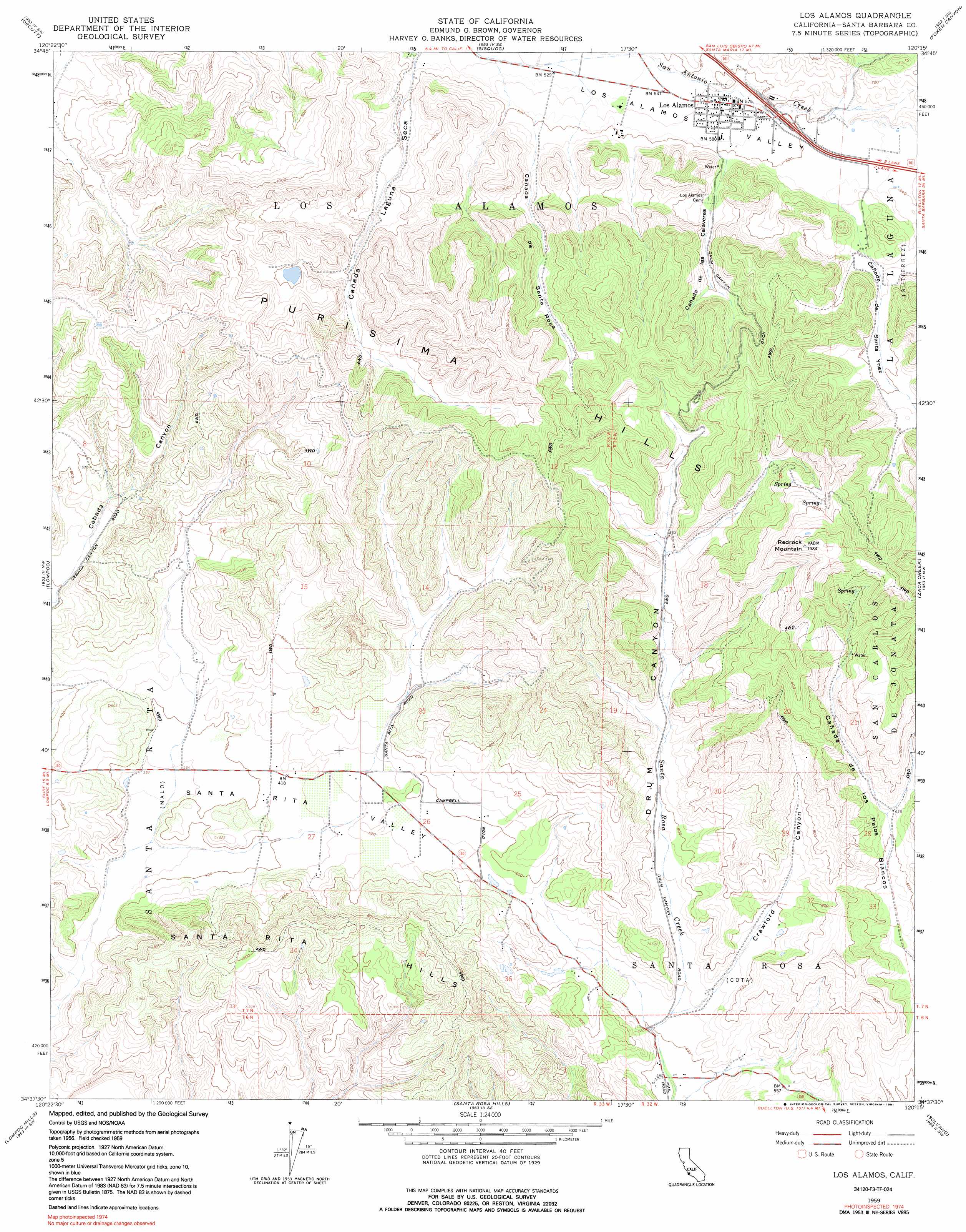
USGS Topo Quad 34120f3 - 1:24,000 scale
| Topo Map Name: | Los Alamos |
| USGS Topo Quad ID: | 34120f3 |
| Print Size: | ca. 21 1/4" wide x 27" high |
| Southeast Coordinates: | 34.625° N latitude / 120.25° W longitude |
| Map Center Coordinates: | 34.6875° N latitude / 120.3125° W longitude |
| U.S. State: | CA |
| Filename: | o34120f3.jpg |
| Download Map JPG Image: | Los Alamos topo map 1:24,000 scale |
| Map Type: | Topographic |
| Topo Series: | 7.5´ |
| Map Scale: | 1:24,000 |
| Source of Map Images: | United States Geological Survey (USGS) |
| Alternate Map Versions: |
Los Alamos CA 1948, updated 1948 Download PDF Buy paper map Los Alamos CA 1948, updated 1956 Download PDF Buy paper map Los Alamos CA 1959, updated 1960 Download PDF Buy paper map Los Alamos CA 1959, updated 1984 Download PDF Buy paper map Los Alamos CA 1959, updated 1991 Download PDF Buy paper map Los Alamos CA 2012 Download PDF Buy paper map Los Alamos CA 2015 Download PDF Buy paper map |
1:24,000 Topo Quads surrounding Los Alamos
Guadalupe |
Santa Maria |
Twitchell Dam |
Tepusquet Canyon |
Manzanita Mountain |
Casmalia |
Orcutt |
Sisquoc |
Foxen Canyon |
Zaca Lake |
Surf |
Lompoc |
Los Alamos |
Zaca Creek |
Los Olivos |
Tranquillon Mountain |
Lompoc Hills |
Santa Rosa Hills |
Solvang |
Santa Ynez |
Point Conception |
Sacate |
Gaviota |
Tajiguas |
> Back to 34120e1 at 1:100,000 scale
> Back to 34120a1 at 1:250,000 scale
> Back to U.S. Topo Maps home
Los Alamos topo map: Gazetteer
Los Alamos: Parks
Arthur Ferrini Park elevation 172m 564′Los Alamos County Park elevation 191m 626′
Los Alamos: Populated Places
Los Alamos elevation 173m 567′Los Alamos: Post Offices
Los Alamos Post Office elevation 173m 567′Los Alamos: Ridges
Purisima Hills elevation 414m 1358′Santa Rita Hills elevation 397m 1302′
Los Alamos: Streams
Cañada De Santa Rosa elevation 182m 597′Los Alamos: Summits
Redrock Mountain elevation 599m 1965′Los Alamos: Valleys
Cañada De Las Calaveras elevation 184m 603′Cañada de Santa Ynez elevation 191m 626′
Cañada Laguna Seca elevation 166m 544′
Crawford Canyon elevation 129m 423′
Drum Canyon elevation 129m 423′
Santa Rita Valley elevation 103m 337′
Los Alamos digital topo map on disk
Buy this Los Alamos topo map showing relief, roads, GPS coordinates and other geographical features, as a high-resolution digital map file on DVD: