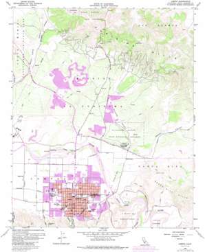
Lompoc Topo Map California
To zoom in, hover over the map of Lompoc
USGS Topo Quad 34120f4 - 1:24,000 scale
| Topo Map Name: | Lompoc |
| USGS Topo Quad ID: | 34120f4 |
| Print Size: | ca. 21 1/4" wide x 27" high |
| Southeast Coordinates: | 34.625° N latitude / 120.375° W longitude |
| Map Center Coordinates: | 34.6875° N latitude / 120.4375° W longitude |
| U.S. State: | CA |
| Filename: | o34120f4.jpg |
| Download Map JPG Image: | Lompoc topo map 1:24,000 scale |
| Map Type: | Topographic |
| Topo Series: | 7.5´ |
| Map Scale: | 1:24,000 |
| Source of Map Images: | United States Geological Survey (USGS) |
| Alternate Map Versions: |
Lompoc CA 1947, updated 1947 Download PDF Buy paper map Lompoc CA 1959, updated 1960 Download PDF Buy paper map Lompoc CA 1959, updated 1976 Download PDF Buy paper map Lompoc CA 1959, updated 1982 Download PDF Buy paper map Lompoc CA 1959, updated 1986 Download PDF Buy paper map Lompoc CA 1959, updated 1986 Download PDF Buy paper map Lompoc CA 1959, updated 1986 Download PDF Buy paper map Lompoc CA 2012 Download PDF Buy paper map Lompoc CA 2015 Download PDF Buy paper map |
1:24,000 Topo Quads surrounding Lompoc
> Back to 34120e1 at 1:100,000 scale
> Back to 34120a1 at 1:250,000 scale
> Back to U.S. Topo Maps home
Lompoc topo map: Gazetteer
Lompoc: Airports
Lompoc Airport elevation 26m 85′Lompoc: Oilfields
Lompoc Oil Field elevation 207m 679′Lompoc: Parks
Anderson Recreation Center elevation 31m 101′Beattie Park elevation 60m 196′
College Park elevation 29m 95′
Ingram Park elevation 40m 131′
Ken Adam Park elevation 62m 203′
La Purisima Mission State Historical Monument elevation 98m 321′
Manville Park elevation 33m 108′
Pioneer Park elevation 34m 111′
River Park elevation 25m 82′
Thompson Park elevation 27m 88′
Westvale Park elevation 34m 111′
Lompoc: Populated Places
Acorn elevation 22m 72′Ellwood Estates elevation 21m 68′
Foothill Estates elevation 37m 121′
Lompoc elevation 32m 104′
Lompoc Village elevation 28m 91′
Mesa Oaks elevation 87m 285′
Mission Hills elevation 99m 324′
Vandenberg Village elevation 113m 370′
Lompoc: Post Offices
Lompoc Post Office elevation 29m 95′Lompoc: Streams
Salsipuedes Creek elevation 35m 114′San Miguelito Creek elevation 17m 55′
Lompoc: Valleys
Cebada Canyon elevation 54m 177′Purisima Canyon elevation 38m 124′
Lompoc digital topo map on disk
Buy this Lompoc topo map showing relief, roads, GPS coordinates and other geographical features, as a high-resolution digital map file on DVD:


