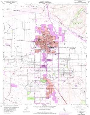
Santa Maria Topo Map California
To zoom in, hover over the map of Santa Maria
USGS Topo Quad 34120h4 - 1:24,000 scale
| Topo Map Name: | Santa Maria |
| USGS Topo Quad ID: | 34120h4 |
| Print Size: | ca. 21 1/4" wide x 27" high |
| Southeast Coordinates: | 34.875° N latitude / 120.375° W longitude |
| Map Center Coordinates: | 34.9375° N latitude / 120.4375° W longitude |
| U.S. State: | CA |
| Filename: | o34120h4.jpg |
| Download Map JPG Image: | Santa Maria topo map 1:24,000 scale |
| Map Type: | Topographic |
| Topo Series: | 7.5´ |
| Map Scale: | 1:24,000 |
| Source of Map Images: | United States Geological Survey (USGS) |
| Alternate Map Versions: |
Santa Maria CA 1959, updated 1960 Download PDF Buy paper map Santa Maria CA 1959, updated 1968 Download PDF Buy paper map Santa Maria CA 1959, updated 1975 Download PDF Buy paper map Santa Maria CA 1959, updated 1977 Download PDF Buy paper map Santa Maria CA 1959, updated 1983 Download PDF Buy paper map Santa Maria CA 1959, updated 1985 Download PDF Buy paper map Santa Maria CA 2012 Download PDF Buy paper map Santa Maria CA 2015 Download PDF Buy paper map |
1:24,000 Topo Quads surrounding Santa Maria
> Back to 34120e1 at 1:100,000 scale
> Back to 34120a1 at 1:250,000 scale
> Back to U.S. Topo Maps home
Santa Maria topo map: Gazetteer
Santa Maria: Airports
Hancock Airport (historical) elevation 70m 229′Machado Airfield (historical) elevation 65m 213′
Marian Medical Center Heliport elevation 75m 246′
Northside Airpark elevation 57m 187′
Santa Maria Airport elevation 68m 223′
Santa Maria: Oilfields
Santa Maria Valley Oil Field elevation 86m 282′Santa Maria: Parks
Adam Park elevation 65m 213′Alice Threfts Park elevation 70m 229′
Armstrong Park elevation 71m 232′
Atkinson Park elevation 63m 206′
Buena Vista Park elevation 67m 219′
Central Plaza Park elevation 67m 219′
Grogan Park elevation 58m 190′
James Hagerman Softball Complex elevation 74m 242′
Memorial Park elevation 66m 216′
Miname Community Park elevation 65m 213′
Miramonte Park North elevation 76m 249′
Miramonte Park South elevation 77m 252′
Oakley Park elevation 61m 200′
Rice Park elevation 69m 226′
Russell Park elevation 61m 200′
Santa Barbara County Fairgrounds and Convention Center elevation 66m 216′
Simas Park elevation 68m 223′
Suey Park elevation 74m 242′
Tunnell Park elevation 73m 239′
Waller Park elevation 79m 259′
Santa Maria: Populated Places
Casa Grande Mobile Home Park elevation 63m 206′Del Cielo Mobile Estates elevation 91m 298′
El Capitan Village Mobile Home Park elevation 67m 219′
La Maria Mobile Home Park elevation 66m 216′
Midco elevation 59m 193′
North Santa Maria elevation 63m 206′
Pacer elevation 53m 173′
Rex elevation 86m 282′
Rosemary elevation 81m 265′
Saint Marie Mobile Home Park elevation 59m 193′
Santa Maria elevation 66m 216′
Village Mobile Home Park elevation 75m 246′
Santa Maria: Post Offices
Santa Maria Post Office elevation 66m 216′Santa Maria: Streams
Nipomo Creek elevation 62m 203′Suey Creek elevation 79m 259′
Santa Maria: Valleys
Nipomo Valley elevation 63m 206′Santa Maria digital topo map on disk
Buy this Santa Maria topo map showing relief, roads, GPS coordinates and other geographical features, as a high-resolution digital map file on DVD:


