Rodanthe Topo Map North Carolina
To zoom in, hover over the map of Rodanthe
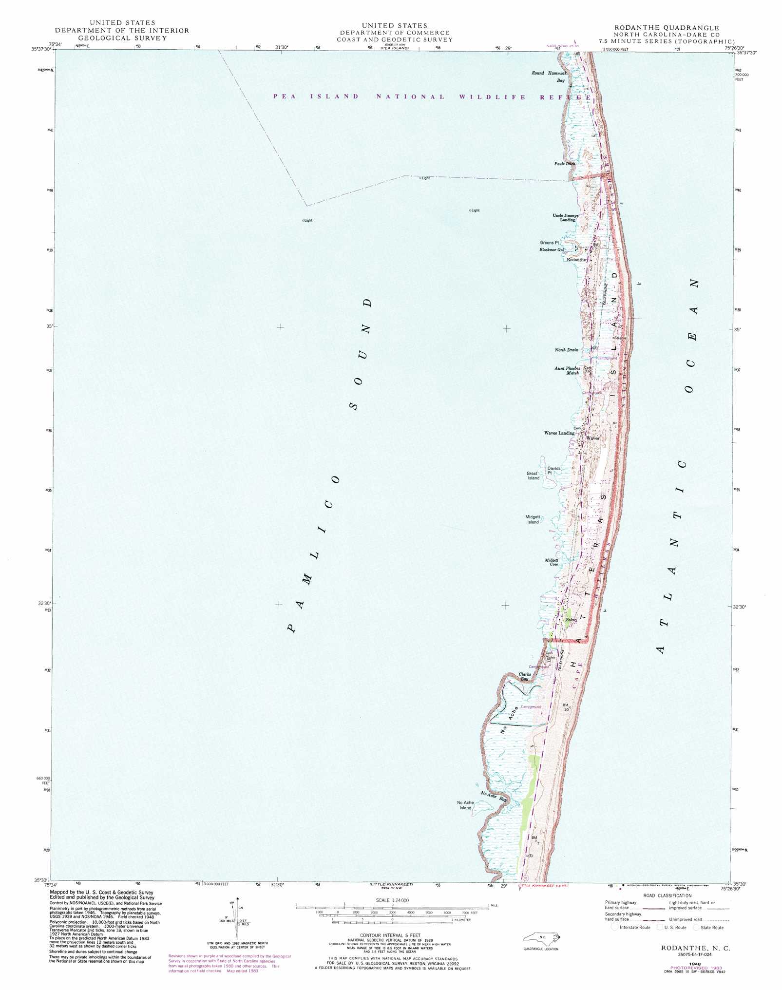
USGS Topo Quad 35075e4 - 1:24,000 scale
| Topo Map Name: | Rodanthe |
| USGS Topo Quad ID: | 35075e4 |
| Print Size: | ca. 21 1/4" wide x 27" high |
| Southeast Coordinates: | 35.5° N latitude / 75.375° W longitude |
| Map Center Coordinates: | 35.5625° N latitude / 75.4375° W longitude |
| U.S. State: | NC |
| Filename: | o35075e4.jpg |
| Download Map JPG Image: | Rodanthe topo map 1:24,000 scale |
| Map Type: | Topographic |
| Topo Series: | 7.5´ |
| Map Scale: | 1:24,000 |
| Source of Map Images: | United States Geological Survey (USGS) |
| Alternate Map Versions: |
Rodanthe NC 2011 Download PDF Buy paper map Rodanthe NC 2013 Download PDF Buy paper map Rodanthe NC 2016 Download PDF Buy paper map |
1:24,000 Topo Quads surrounding Rodanthe
Wanchese |
Oregon Inlet |
|||
Stumpy Point |
||||
Rodanthe |
||||
Little Kinnakeet |
||||
Buxton |
> Back to 35075e1 at 1:100,000 scale
> Back to 35074a1 at 1:250,000 scale
> Back to U.S. Topo Maps home
Rodanthe topo map: Gazetteer
Rodanthe: Bars
Wimble Shoals elevation 0m 0′Rodanthe: Bays
Clarks Bay elevation 0m 0′Midgett Cove elevation 0m 0′
No Ache Bay elevation 0m 0′
Round Hammock Bay elevation 0m 0′
Rodanthe: Capes
Davids Point elevation 0m 0′Green Point elevation 1m 3′
Greens Point elevation 2m 6′
Rodanthe: Channels
Chicamacomico Channel (historical) elevation 0m 0′Rodanthe: Guts
Blackmar Gut elevation 0m 0′Chickinacommock (historical) elevation 0m 0′
Rodanthe: Islands
Great Island elevation 1m 3′Midgett Island elevation 0m 0′
No Ache Island elevation 0m 0′
Outer Banks elevation 1m 3′
Rodanthe: Parks
National Park Service Headquarters elevation 0m 0′Rodanthe: Populated Places
Rodanthe elevation 1m 3′Salvo elevation 1m 3′
South Rodanthe elevation 1m 3′
Steeple elevation 0m 0′
Uncle Jimmys Landing elevation 1m 3′
Waves elevation 1m 3′
Waves Landing elevation 0m 0′
Rodanthe: Streams
North Drain elevation 0m 0′Pauls Ditch elevation 0m 0′
Rodanthe: Swamps
Aunt Phoebes Marsh elevation 1m 3′No Ache elevation 0m 0′
Rodanthe digital topo map on disk
Buy this Rodanthe topo map showing relief, roads, GPS coordinates and other geographical features, as a high-resolution digital map file on DVD:
Atlantic Coast (NY, NJ, PA, DE, MD, VA, NC)
Buy digital topo maps: Atlantic Coast (NY, NJ, PA, DE, MD, VA, NC)
 map DVD")