Oregon Inlet Topo Map North Carolina
To zoom in, hover over the map of Oregon Inlet
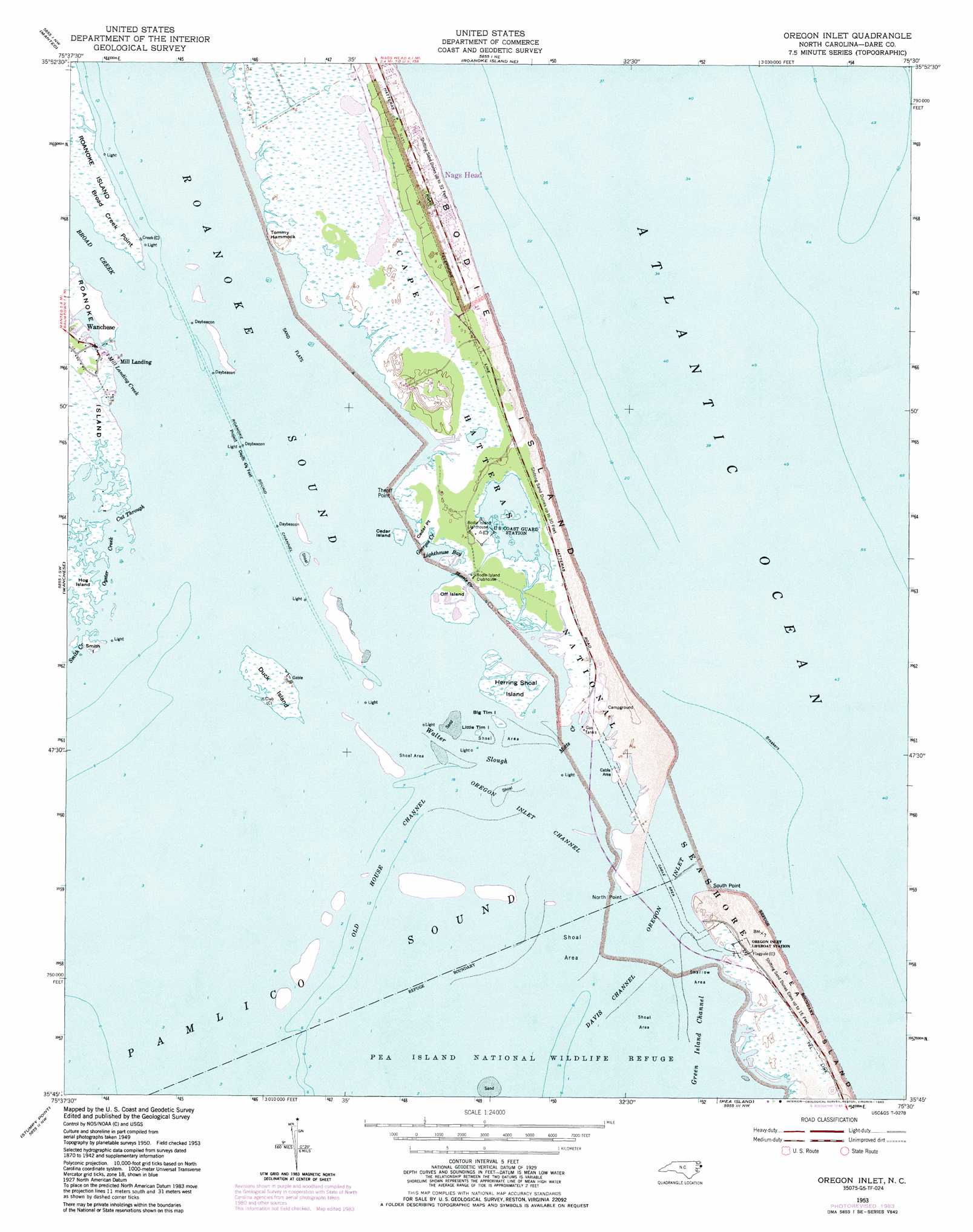
USGS Topo Quad 35075g5 - 1:24,000 scale
| Topo Map Name: | Oregon Inlet |
| USGS Topo Quad ID: | 35075g5 |
| Print Size: | ca. 21 1/4" wide x 27" high |
| Southeast Coordinates: | 35.75° N latitude / 75.5° W longitude |
| Map Center Coordinates: | 35.8125° N latitude / 75.5625° W longitude |
| U.S. State: | NC |
| Filename: | o35075g5.jpg |
| Download Map JPG Image: | Oregon Inlet topo map 1:24,000 scale |
| Map Type: | Topographic |
| Topo Series: | 7.5´ |
| Map Scale: | 1:24,000 |
| Source of Map Images: | United States Geological Survey (USGS) |
| Alternate Map Versions: |
Oregon Inlet NC 2011 Download PDF Buy paper map Oregon Inlet NC 2013 Download PDF Buy paper map Oregon Inlet NC 2016 Download PDF Buy paper map |
1:24,000 Topo Quads surrounding Oregon Inlet
Point Harbor |
Kitty Hawk |
|||
Manns Harbor |
Manteo |
Roanoke Island Ne |
||
East Lake Se |
Wanchese |
Oregon Inlet |
||
Engelhard Ne |
Stumpy Point |
|||
Long Shoal Point |
Rodanthe |
> Back to 35075e1 at 1:100,000 scale
> Back to 35074a1 at 1:250,000 scale
> Back to U.S. Topo Maps home
Oregon Inlet topo map: Gazetteer
Oregon Inlet: Bays
Georges Creek elevation 0m 0′Lighthouse Bay elevation 0m 0′
Motts Creek elevation 0m 0′
Oyster Creek elevation 0m 0′
Port Ferinando (historical) elevation 0m 0′
Roanoke Sound elevation 0m 0′
Oregon Inlet: Beaches
Coquina Beach elevation 1m 3′Oregon Inlet: Benches
Coquina Bench elevation 0m 0′Oregon Inlet: Bridges
Herbert C Bonner Bridge elevation 0m 0′Herbert C Bonner Bridge elevation 0m 0′
Oregon Inlet: Capes
Broad Creek Point elevation 0m 0′Cedar Point elevation 1m 3′
North Point elevation 0m 0′
South Point elevation 0m 0′
Theoff Point elevation 0m 0′
Oregon Inlet: Channels
Cut Through elevation 0m 0′Davis Channel elevation 0m 0′
Green Island Channel elevation 0m 0′
Old House Channel elevation 0m 0′
Oregon Inlet elevation 0m 0′
Oregon Inlet Channel elevation 0m 0′
Roanoke Sound Channel elevation 0m 0′
Walter Slough elevation 0m 0′
Oregon Inlet: Guts
Blossie Creek elevation 0m 0′Smith Creek elevation 0m 0′
Oregon Inlet: Islands
Big Tim Island elevation 0m 0′Cedar Island elevation 0m 0′
Duck Island elevation 0m 0′
Herring Shoal Island elevation 0m 0′
Hog Island elevation 0m 0′
Little Tim Island elevation 0m 0′
Off Island elevation 1m 3′
Smith Island elevation 0m 0′
Tommy Hammock elevation 1m 3′
Oregon Inlet: Parks
Bodie Island Visitor Center elevation 1m 3′Oregon Inlet Fishing Center elevation 0m 0′
Oregon Inlet: Streams
Broad Creek elevation 0m 0′Mill Landing Creek elevation 0m 0′
Oregon Inlet: Woods
Billys Woods elevation 1m 3′Oregon Inlet digital topo map on disk
Buy this Oregon Inlet topo map showing relief, roads, GPS coordinates and other geographical features, as a high-resolution digital map file on DVD:
Atlantic Coast (NY, NJ, PA, DE, MD, VA, NC)
Buy digital topo maps: Atlantic Coast (NY, NJ, PA, DE, MD, VA, NC)
 map DVD")