Roanoke Island Ne Topo Map North Carolina
To zoom in, hover over the map of Roanoke Island Ne
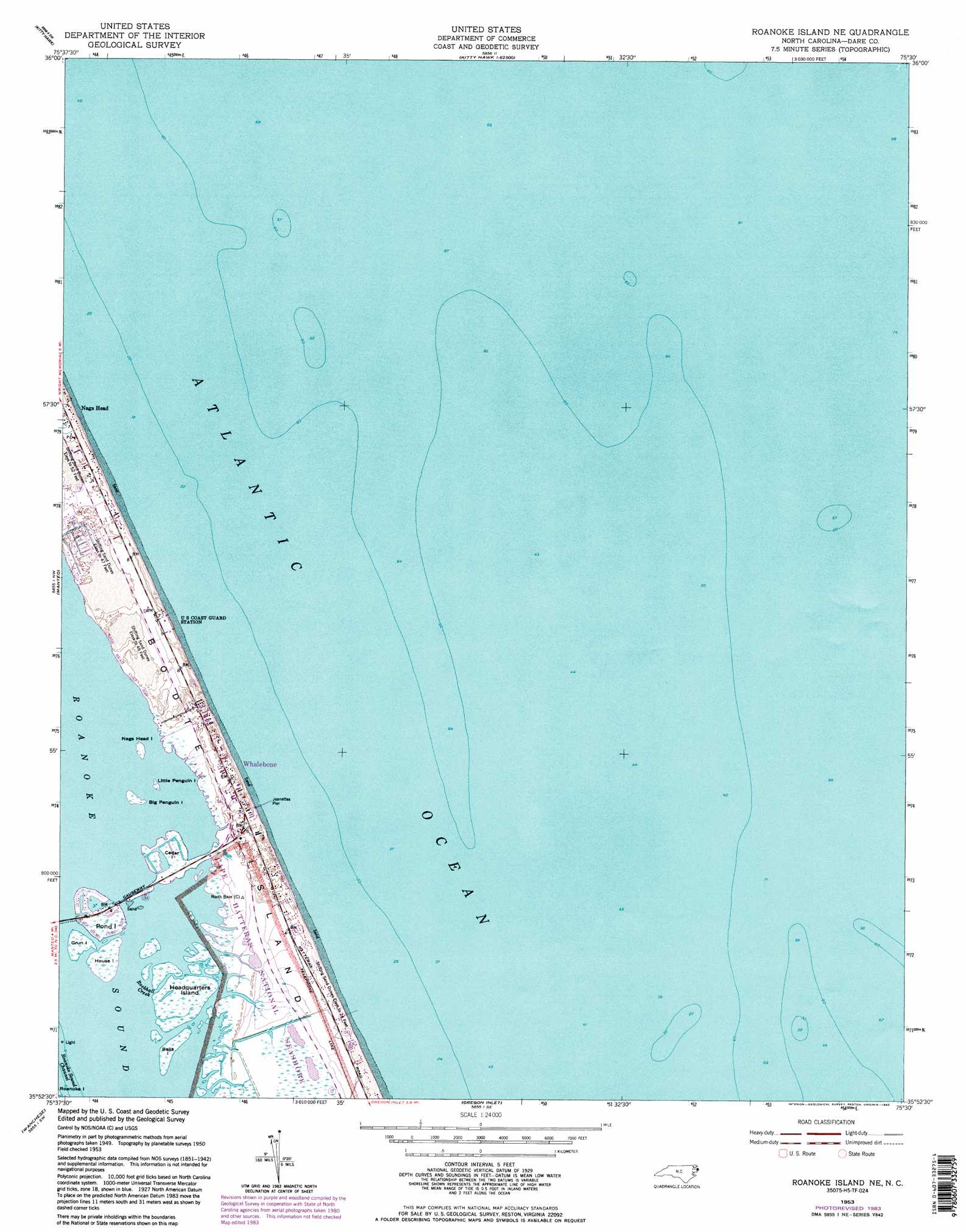
USGS Topo Quad 35075h5 - 1:24,000 scale
| Topo Map Name: | Roanoke Island Ne |
| USGS Topo Quad ID: | 35075h5 |
| Print Size: | ca. 21 1/4" wide x 27" high |
| Southeast Coordinates: | 35.875° N latitude / 75.5° W longitude |
| Map Center Coordinates: | 35.9375° N latitude / 75.5625° W longitude |
| U.S. State: | NC |
| Filename: | o35075h5.jpg |
| Download Map JPG Image: | Roanoke Island Ne topo map 1:24,000 scale |
| Map Type: | Topographic |
| Topo Series: | 7.5´ |
| Map Scale: | 1:24,000 |
| Source of Map Images: | United States Geological Survey (USGS) |
| Alternate Map Versions: |
Roanoke Island NE NC 1953, updated 1955 Download PDF Buy paper map Roanoke Island NE NC 1953, updated 1969 Download PDF Buy paper map Roanoke Island NE NC 1953, updated 1977 Download PDF Buy paper map Roanoke Island NE NC 1953, updated 1980 Download PDF Buy paper map Roanoke Island NE NC 1953, updated 1983 Download PDF Buy paper map Roanoke Island NE NC 1953, updated 1983 Download PDF Buy paper map Roanoke Island NE NC 2011 Download PDF Buy paper map Roanoke Island NE NC 2013 Download PDF Buy paper map Roanoke Island NE NC 2016 Download PDF Buy paper map |
1:24,000 Topo Quads surrounding Roanoke Island Ne
Jarvisburg |
Martin Point |
|||
Point Harbor |
Kitty Hawk |
|||
Manns Harbor |
Manteo |
Roanoke Island Ne |
||
East Lake Se |
Wanchese |
Oregon Inlet |
||
Engelhard Ne |
Stumpy Point |
> Back to 35075e1 at 1:100,000 scale
> Back to 35074a1 at 1:250,000 scale
> Back to U.S. Topo Maps home
Roanoke Island Ne topo map: Gazetteer
Roanoke Island Ne: Areas
Whalebone elevation 6m 19′Roanoke Island Ne: Bridges
Melvin R Daniels Bridge elevation 0m 0′Roanoke Island Ne: Guts
Roanoke Inlet (historical) elevation 1m 3′Rockhall Creek elevation 0m 0′
Roanoke Island Ne: Islands
Bells Island elevation 0m 0′Big Penguin Island elevation 0m 0′
Bodie Island elevation 1m 3′
Cedar Island elevation 1m 3′
Cow Island (historical) elevation 0m 0′
Green Islands elevation 0m 0′
Grun Island elevation 0m 0′
Headquarters Island elevation 0m 0′
House Island elevation 0m 0′
Little Penguin Island elevation 0m 0′
Nags Head Island elevation 0m 0′
Penguins Islands elevation 0m 0′
Pond Island elevation 0m 0′
Roanoke Island Ne: Parks
Whalebone Junction Information Station elevation 1m 3′Roanoke Island Ne: Populated Places
Nags Head elevation 2m 6′Whalebone elevation 2m 6′
Roanoke Island Ne: Post Offices
Nags Head Post Office (historical) elevation 2m 6′Roanoke Island Ne: Summits
Seven Sisters elevation 5m 16′Roanoke Island Ne: Swamps
Bodie Island Marshes elevation 0m 0′Roanoke Island Ne digital topo map on disk
Buy this Roanoke Island Ne topo map showing relief, roads, GPS coordinates and other geographical features, as a high-resolution digital map file on DVD:
Atlantic Coast (NY, NJ, PA, DE, MD, VA, NC)
Buy digital topo maps: Atlantic Coast (NY, NJ, PA, DE, MD, VA, NC)
 map DVD")