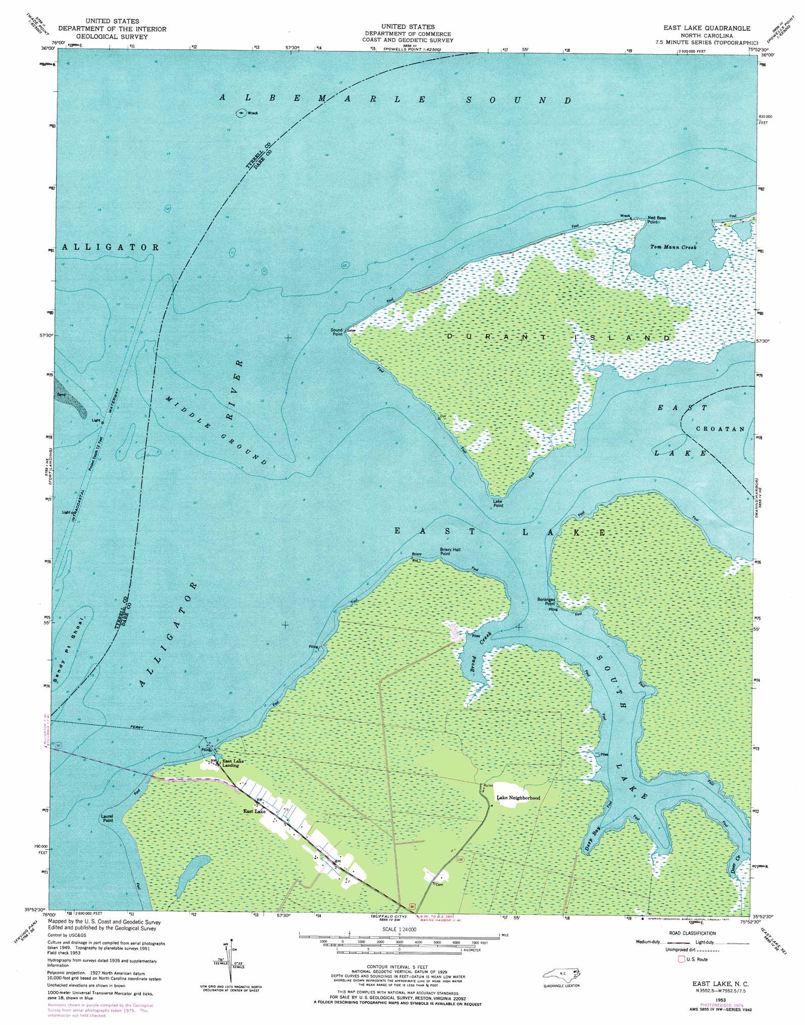
East Lake Topo Map North Carolina
To zoom in, hover over the map of East Lake
USGS Topo Quad 35075h8 - 1:24,000 scale
| Topo Map Name: | East Lake |
| USGS Topo Quad ID: | 35075h8 |
| Print Size: | ca. 21 1/4" wide x 27" high |
| Southeast Coordinates: | 35.875° N latitude / 75.875° W longitude |
| Map Center Coordinates: | 35.9375° N latitude / 75.9375° W longitude |
| U.S. State: | NC |
| Filename: | o35075h8.jpg |
| Download Map JPG Image: | East Lake topo map 1:24,000 scale |
| Map Type: | Topographic |
| Topo Series: | 7.5´ |
| Map Scale: | 1:24,000 |
| Source of Map Images: | United States Geological Survey (USGS) |
| Alternate Map Versions: |
East Lake NC 1953, updated 1956 Download PDF Buy paper map East Lake NC 1953, updated 1956 Download PDF Buy paper map East Lake NC 1953, updated 1977 Download PDF Buy paper map East Lake NC 2011 Download PDF Buy paper map East Lake NC 2013 Download PDF Buy paper map East Lake NC 2016 Download PDF Buy paper map |
1:24,000 Topo Quads surrounding East Lake
Weeksville |
Wade Point |
Camden Point |
Jarvisburg |
Martin Point |
Stevenson Point |
Point Harbor |
Kitty Hawk |
||
Columbia East |
Fort Landing |
East Lake |
Manns Harbor |
Manteo |
Scotia |
Frying Pan |
Buffalo City |
East Lake Se |
Wanchese |
Fairfield Nw |
Fairfield Ne |
Engelhard Nw |
Engelhard Ne |
Stumpy Point |
> Back to 35075e1 at 1:100,000 scale
> Back to 35074a1 at 1:250,000 scale
> Back to U.S. Topo Maps home
East Lake topo map: Gazetteer
East Lake: Bars
Middle Ground elevation 0m 0′Sandy Point Shoal elevation 0m 0′
East Lake: Bays
Broad Creek elevation 0m 0′Deep Bay elevation 0m 0′
Deer Creek elevation 0m 0′
Tom Mann Creek elevation 0m 0′
East Lake: Capes
Boranges Point elevation 0m 0′Briery Hall Point elevation 0m 0′
Lake Point elevation 0m 0′
Ned Bees Point elevation 1m 3′
Sound Point elevation 0m 0′
East Lake: Islands
Durant Island elevation 0m 0′East Lake: Lakes
East Lake elevation 0m 0′South Lake elevation 0m 0′
East Lake: Populated Places
East Lake elevation 0m 0′East Lake Landing elevation 1m 3′
Lake Neighborhood elevation 0m 0′
East Lake: Streams
Alligator River elevation 0m 0′East Lake digital topo map on disk
Buy this East Lake topo map showing relief, roads, GPS coordinates and other geographical features, as a high-resolution digital map file on DVD:
Atlantic Coast (NY, NJ, PA, DE, MD, VA, NC)
Buy digital topo maps: Atlantic Coast (NY, NJ, PA, DE, MD, VA, NC)
 map DVD")