Little Fishing Point Topo Map North Carolina
To zoom in, hover over the map of Little Fishing Point
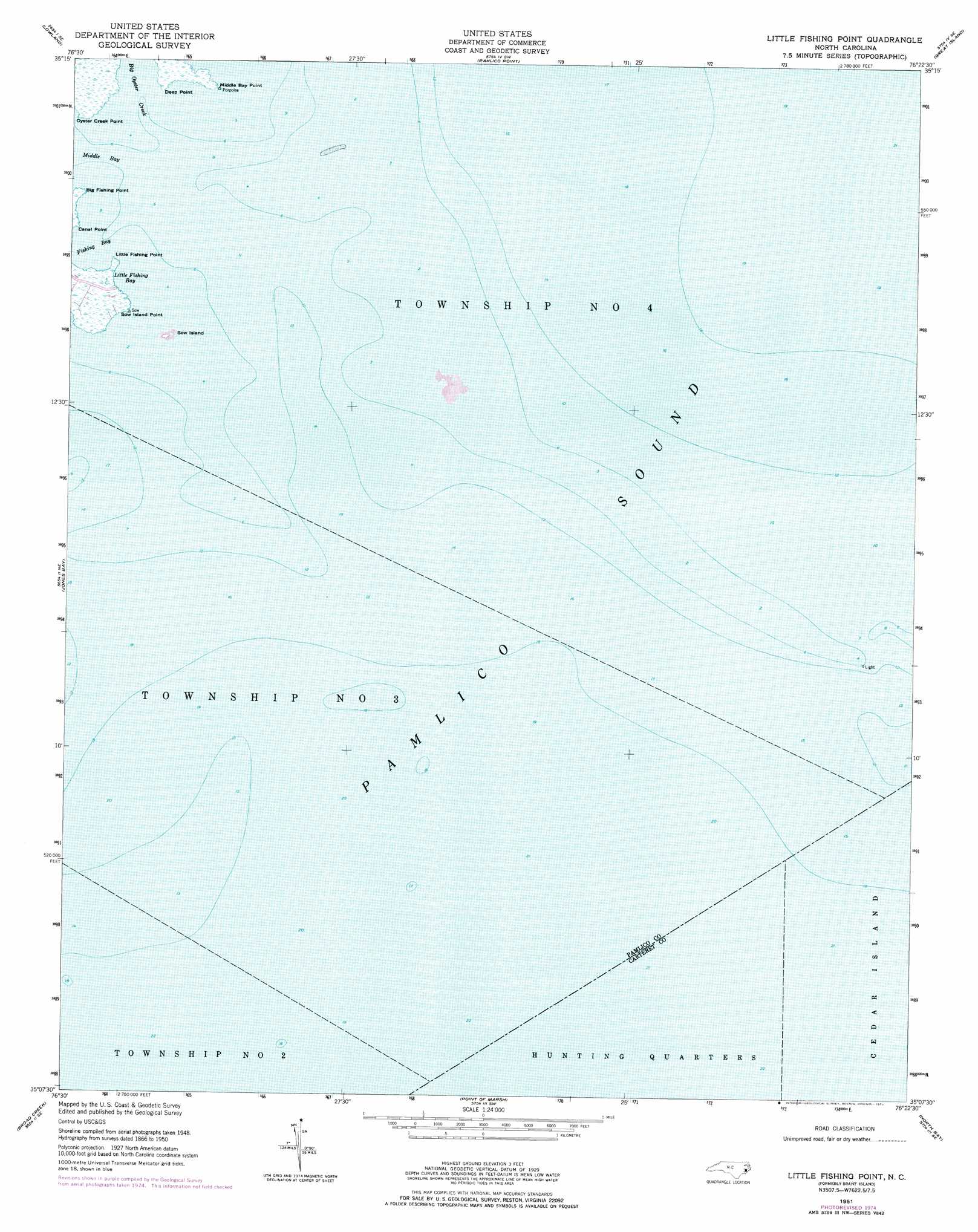
USGS Topo Quad 35076b4 - 1:24,000 scale
| Topo Map Name: | Little Fishing Point |
| USGS Topo Quad ID: | 35076b4 |
| Print Size: | ca. 21 1/4" wide x 27" high |
| Southeast Coordinates: | 35.125° N latitude / 76.375° W longitude |
| Map Center Coordinates: | 35.1875° N latitude / 76.4375° W longitude |
| U.S. State: | NC |
| Filename: | o35076b4.jpg |
| Download Map JPG Image: | Little Fishing Point topo map 1:24,000 scale |
| Map Type: | Topographic |
| Topo Series: | 7.5´ |
| Map Scale: | 1:24,000 |
| Source of Map Images: | United States Geological Survey (USGS) |
| Alternate Map Versions: |
Brant Island NC 1951 Download PDF Buy paper map Little Fishing Point NC 1951, updated 1977 Download PDF Buy paper map Little Fishing Point NC 2000, updated 2003 Download PDF Buy paper map Little Fishing Point NC 2010 Download PDF Buy paper map Little Fishing Point NC 2013 Download PDF Buy paper map Little Fishing Point NC 2016 Download PDF Buy paper map |
1:24,000 Topo Quads surrounding Little Fishing Point
Ransomville |
Pamlico Beach |
Scranton |
Swanquarter |
New Holland |
South Creek |
Lowland |
Pamlico Point |
Great Island |
Bluff Point |
Vandemere |
Jones Bay |
Little Fishing Point |
||
Oriental |
Broad Creek |
Point Of Marsh |
North Bay |
|
Merrimon |
South River |
Long Bay |
Atlantic |
Atlantic East |
> Back to 35076a1 at 1:100,000 scale
> Back to 35076a1 at 1:250,000 scale
> Back to U.S. Topo Maps home
Little Fishing Point topo map: Gazetteer
Little Fishing Point: Bays
Big Oyster Creek elevation 0m 0′Fishing Bay elevation 0m 0′
Little Fishing Bay elevation 0m 0′
Little Fishing Point: Capes
Big Fishing Point elevation 0m 0′Canal Point elevation 0m 0′
Deep Point elevation 1m 3′
Little Fishing Point elevation 0m 0′
Middle Bay Point elevation 0m 0′
Oyster Creek Point elevation 1m 3′
Sow Island Point elevation 0m 0′
Little Fishing Point: Islands
Brant Island (historical) elevation 0m 0′Sow Island elevation 0m 0′
Little Fishing Point digital topo map on disk
Buy this Little Fishing Point topo map showing relief, roads, GPS coordinates and other geographical features, as a high-resolution digital map file on DVD:
Atlantic Coast (NY, NJ, PA, DE, MD, VA, NC)
Buy digital topo maps: Atlantic Coast (NY, NJ, PA, DE, MD, VA, NC)
 map DVD")