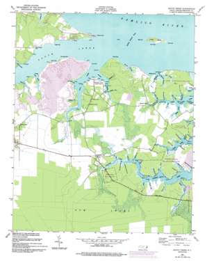
South Creek Topo Map North Carolina
To zoom in, hover over the map of South Creek
USGS Topo Quad 35076c6 - 1:24,000 scale
| Topo Map Name: | South Creek |
| USGS Topo Quad ID: | 35076c6 |
| Print Size: | ca. 21 1/4" wide x 27" high |
| Southeast Coordinates: | 35.25° N latitude / 76.625° W longitude |
| Map Center Coordinates: | 35.3125° N latitude / 76.6875° W longitude |
| U.S. State: | NC |
| Filename: | o35076c6.jpg |
| Download Map JPG Image: | South Creek topo map 1:24,000 scale |
| Map Type: | Topographic |
| Topo Series: | 7.5´ |
| Map Scale: | 1:24,000 |
| Source of Map Images: | United States Geological Survey (USGS) |
| Alternate Map Versions: |
South Creek NC 1950, updated 1952 Download PDF Buy paper map South Creek NC 1950, updated 1977 Download PDF Buy paper map South Creek NC 1950, updated 1983 Download PDF Buy paper map South Creek NC 1950, updated 1993 Download PDF Buy paper map South Creek NC 2000, updated 2001 Download PDF Buy paper map South Creek NC 2010 Download PDF Buy paper map South Creek NC 2013 Download PDF Buy paper map South Creek NC 2016 Download PDF Buy paper map |
1:24,000 Topo Quads surrounding South Creek
> Back to 35076a1 at 1:100,000 scale
> Back to 35076a1 at 1:250,000 scale
> Back to U.S. Topo Maps home
South Creek topo map: Gazetteer
South Creek: Bays
Gray Gut elevation 0m 0′Old House Cove elevation 0m 0′
South Creek: Capes
Beargrass Point elevation 0m 0′Betty Point elevation 0m 0′
Bostic Point elevation 0m 0′
Brick Hill Point elevation 0m 0′
Brick Mill Point elevation 0m 0′
Buoy Point elevation 1m 3′
Cedar Point elevation 0m 0′
Dumplin Point elevation 0m 0′
East Point elevation 0m 0′
Flower Point elevation 0m 0′
Fork Point elevation 1m 3′
Gum Point elevation 0m 0′
Hauldown Point elevation 0m 0′
Herring Point elevation 0m 0′
Hickory Point elevation 1m 3′
Holland Point elevation 0m 0′
How Point elevation 0m 0′
Long Point elevation 0m 0′
Old Field Point elevation 7m 22′
Old Field Point elevation 1m 3′
Old Mill Point elevation 1m 3′
Reed Point elevation 0m 0′
Sage Point elevation 0m 0′
Sheeppen Point elevation 0m 0′
Syfax Point elevation 0m 0′
Tuthill Point elevation 0m 0′
West End elevation 0m 0′
Whitehurst Point elevation 0m 0′
Wood Landing Point elevation 1m 3′
South Creek: Channels
Indian Island Slue elevation 0m 0′South Creek: Dams
T G Clay Pond Dam Number Three elevation 7m 22′T G Clay Pond Dam Number Two elevation 8m 26′
T G Slimes Pond Dam Number One elevation 6m 19′
South Creek: Guts
Alligator Gut elevation 0m 0′Big Pond Gut elevation 0m 0′
Camphion Gut elevation 0m 0′
Huddy Gut elevation 1m 3′
Neezar Gut elevation 0m 0′
Persimmon Tree Landing Gut elevation 0m 0′
South Creek: Islands
Indian Island elevation 1m 3′South Creek: Populated Places
Campbell Creek elevation 1m 3′Jones elevation 1m 3′
Reads Chapel elevation 2m 6′
South Creek elevation 1m 3′
Spring Creek elevation 1m 3′
Vinegar Hill elevation 1m 3′
South Creek: Reservoirs
T G Clay Pond elevation 8m 26′T G Clay Pond Number Three elevation 7m 22′
T G Slimes Pond Number One elevation 6m 19′
South Creek: Streams
Alligator Gut elevation 0m 0′Barnett Gut elevation 1m 3′
Betty Creek elevation 0m 0′
Big Kernel Tree Branch elevation 0m 0′
Bond Creek elevation 0m 0′
Carrie Creek elevation 0m 0′
Cuff Tarkiln Creek elevation 0m 0′
Cypress Branch elevation 0m 0′
Davis Creek elevation 0m 0′
Dumplin Gut elevation 0m 0′
East Prong Cypress Branch elevation 0m 0′
Facing Gut elevation 0m 0′
Flannigan Gut elevation 4m 13′
Hatter Creek elevation 0m 0′
Lee Creek elevation 0m 0′
Little Kernel Tree Branch elevation 0m 0′
Long Creek elevation 0m 0′
Mill Creek elevation 0m 0′
Muddy Creek elevation 0m 0′
Myrtle Marsh Gut elevation 1m 3′
Northeast Prong elevation 0m 0′
Overton Creek elevation 0m 0′
Pate Creek elevation 0m 0′
Pitch Hole Gut elevation 0m 0′
Pot Gut elevation 0m 0′
Robbin Gut elevation 0m 0′
Schoolhouse Gut elevation 0m 0′
Sheepskin Creek elevation 0m 0′
Shop Gut elevation 0m 0′
Short Creek elevation 0m 0′
Smith Creek elevation 0m 0′
South Creek elevation 0m 0′
Strawhorn Creek elevation 0m 0′
Tar Landing Gut elevation 0m 0′
Tetterton Gut elevation 1m 3′
Tooley Creek elevation 0m 0′
Welshman Gut elevation 1m 3′
Wilson Gut elevation 0m 0′
South Creek digital topo map on disk
Buy this South Creek topo map showing relief, roads, GPS coordinates and other geographical features, as a high-resolution digital map file on DVD:
Atlantic Coast (NY, NJ, PA, DE, MD, VA, NC)
Buy digital topo maps: Atlantic Coast (NY, NJ, PA, DE, MD, VA, NC)


