Scranton Topo Map North Carolina
To zoom in, hover over the map of Scranton
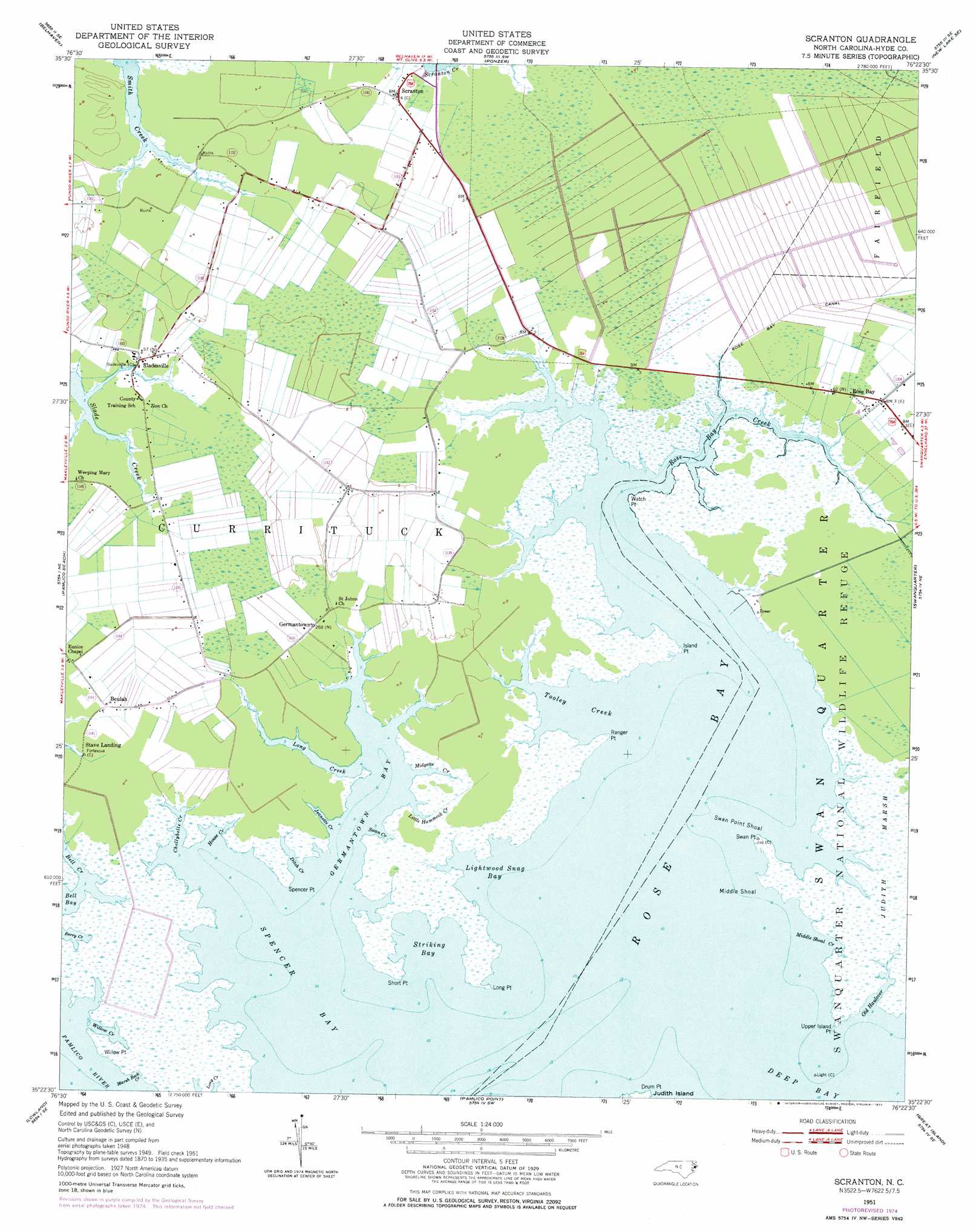
USGS Topo Quad 35076d4 - 1:24,000 scale
| Topo Map Name: | Scranton |
| USGS Topo Quad ID: | 35076d4 |
| Print Size: | ca. 21 1/4" wide x 27" high |
| Southeast Coordinates: | 35.375° N latitude / 76.375° W longitude |
| Map Center Coordinates: | 35.4375° N latitude / 76.4375° W longitude |
| U.S. State: | NC |
| Filename: | o35076d4.jpg |
| Download Map JPG Image: | Scranton topo map 1:24,000 scale |
| Map Type: | Topographic |
| Topo Series: | 7.5´ |
| Map Scale: | 1:24,000 |
| Source of Map Images: | United States Geological Survey (USGS) |
| Alternate Map Versions: |
Scranton NC 1951, updated 1953 Download PDF Buy paper map Scranton NC 1951, updated 1977 Download PDF Buy paper map Scranton NC 2002, updated 2002 Download PDF Buy paper map Scranton NC 2010 Download PDF Buy paper map Scranton NC 2013 Download PDF Buy paper map Scranton NC 2016 Download PDF Buy paper map |
1:24,000 Topo Quads surrounding Scranton
Pike Road |
Pungo Lake |
New Lake Nw |
New Lake |
Fairfield Nw |
Pantego |
Belhaven |
Ponzer |
New Lake Se |
Fairfield |
Ransomville |
Pamlico Beach |
Scranton |
Swanquarter |
New Holland |
South Creek |
Lowland |
Pamlico Point |
Great Island |
Bluff Point |
Vandemere |
Jones Bay |
Little Fishing Point |
> Back to 35076a1 at 1:100,000 scale
> Back to 35076a1 at 1:250,000 scale
> Back to U.S. Topo Maps home
Scranton topo map: Gazetteer
Scranton: Airports
Garrish Farm Airport elevation 1m 3′Scranton: Areas
Bell Island Recreation Area elevation 1m 3′Scranton: Bars
Middle Shoal elevation 0m 0′Swan Point Shoal elevation 0m 0′
Scranton: Bays
Bell Bay elevation 0m 0′Berry Creek elevation 0m 0′
Germantown Bay elevation 0m 0′
Lightwood Snag Bay elevation 0m 0′
Marsh Rock Creek elevation 0m 0′
Middle Shoal Creek elevation 0m 0′
Rose Bay elevation 0m 0′
Spencer Bay elevation 0m 0′
Striking Bay elevation 0m 0′
Tooley Creek elevation 0m 0′
Willow Creek elevation 0m 0′
Scranton: Capes
Drum Point elevation 0m 0′Island Point elevation 1m 3′
Long Point elevation 0m 0′
Ranger Point elevation 1m 3′
Short Point elevation 0m 0′
Spencer Point elevation 1m 3′
Swan Point elevation 0m 0′
Upper Island Point elevation 0m 0′
Watch Point elevation 0m 0′
Willow Point elevation 1m 3′
Scranton: Populated Places
Beulah elevation 1m 3′Germantown elevation 1m 3′
Rose Bay elevation 1m 3′
Scranton elevation 0m 0′
Sladesville elevation 1m 3′
Scranton: Streams
Bell Creek elevation 0m 0′Chellybelle Creek elevation 0m 0′
Ditch Creek elevation 0m 0′
House Creek elevation 0m 0′
Jeanette Creek elevation 0m 0′
Little Hammock Creek elevation 0m 0′
Long Creek elevation 0m 0′
Midgette Creek elevation 0m 0′
Old Haulover elevation 0m 0′
Rose Bay Creek elevation 0m 0′
Swan Creek elevation 0m 0′
Scranton digital topo map on disk
Buy this Scranton topo map showing relief, roads, GPS coordinates and other geographical features, as a high-resolution digital map file on DVD:
Atlantic Coast (NY, NJ, PA, DE, MD, VA, NC)
Buy digital topo maps: Atlantic Coast (NY, NJ, PA, DE, MD, VA, NC)
 map DVD")