Bath Topo Map North Carolina
To zoom in, hover over the map of Bath
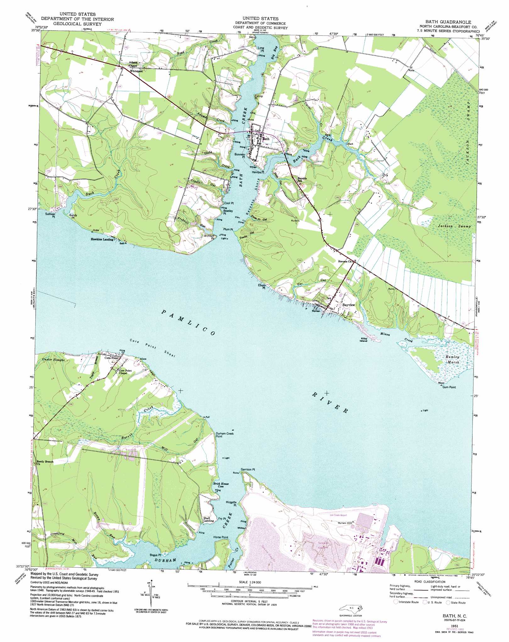
USGS Topo Quad 35076d7 - 1:24,000 scale
| Topo Map Name: | Bath |
| USGS Topo Quad ID: | 35076d7 |
| Print Size: | ca. 21 1/4" wide x 27" high |
| Southeast Coordinates: | 35.375° N latitude / 76.75° W longitude |
| Map Center Coordinates: | 35.4375° N latitude / 76.8125° W longitude |
| U.S. State: | NC |
| Filename: | o35076d7.jpg |
| Download Map JPG Image: | Bath topo map 1:24,000 scale |
| Map Type: | Topographic |
| Topo Series: | 7.5´ |
| Map Scale: | 1:24,000 |
| Source of Map Images: | United States Geological Survey (USGS) |
| Alternate Map Versions: |
Bath NC 1951, updated 1952 Download PDF Buy paper map Bath NC 1951, updated 1977 Download PDF Buy paper map Bath NC 1951, updated 1983 Download PDF Buy paper map Bath NC 1951, updated 1994 Download PDF Buy paper map Bath NC 2010 Download PDF Buy paper map Bath NC 2013 Download PDF Buy paper map Bath NC 2016 Download PDF Buy paper map |
1:24,000 Topo Quads surrounding Bath
Old Ford |
Farmlife |
Hoke |
Pike Road |
Pungo Lake |
Washington |
Bunyan |
Pinetown |
Pantego |
Belhaven |
Hackney |
Blounts Bay |
Bath |
Ransomville |
Pamlico Beach |
Ernul |
Edward |
Aurora |
South Creek |
Lowland |
Askin |
Reelsboro |
Bayboro |
Vandemere |
Jones Bay |
> Back to 35076a1 at 1:100,000 scale
> Back to 35076a1 at 1:250,000 scale
> Back to U.S. Topo Maps home
Bath topo map: Gazetteer
Bath: Airports
Lee Creek Airport elevation 4m 13′Bath: Bars
Core Point Shoal elevation 0m 0′Bath: Bays
Big Bay elevation -1m -4′Brick House Cove elevation 7m 22′
Mixon Creek elevation 0m 0′
Bath: Beaches
Respess Shore elevation 0m 0′Bath: Capes
Archbell Point elevation 3m 9′Bear Grass Point (historical) elevation 4m 13′
Beasley Point elevation 3m 9′
Bogus Point elevation 0m 0′
Bonners Point elevation -1m -4′
Catnip Point elevation -1m -4′
Cool Point elevation 4m 13′
Durham Creek Point elevation 3m 9′
Eborn Point elevation 0m 0′
Fry Point elevation 1m 3′
Garrison Point elevation 1m 3′
Gum Point elevation 0m 0′
Handys Point elevation 2m 6′
Horse Point elevation 3m 9′
Long Point elevation 1m 3′
Midgette Point elevation 0m 0′
Plum Point elevation 0m 0′
Sandy Point elevation 0m 0′
Sullivan Point elevation 1m 3′
Bath: Guts
Cupler Sloughs elevation 2m 6′Mill Gut elevation 1m 3′
Bath: Islands
Kilby Island elevation 1m 3′Bath: Populated Places
Bath elevation 4m 13′Bayview elevation 2m 6′
Core Point elevation 3m 9′
Hawkins Landing elevation 1m 3′
Pomouk Indian Village (historical) elevation 1m 3′
Shell Landing elevation 1m 3′
Whitepost elevation 5m 16′
Bath: Post Offices
Bath Post Office elevation 3m 9′Bath: Streams
Adams Creek elevation -1m -4′Archbell Gut elevation 2m 6′
Back Creek elevation -1m -4′
Barris Creek elevation 0m 0′
Bath Creek elevation 0m 0′
Brown Run elevation 0m 0′
Cradle Gut elevation 0m 0′
Crawford Mill Run elevation 0m 0′
Duck Creek elevation 0m 0′
Durham Creek elevation 0m 0′
Gar Gut elevation 2m 6′
Glebe Creek elevation -1m -4′
Plum Point Gut elevation 0m 0′
Porter Creek elevation 0m 0′
Slade Gut elevation -1m -4′
Taylor Branch elevation 0m 0′
Teachs Gut elevation 0m 0′
Bath: Swamps
Rumley Marsh elevation 0m 0′Bath digital topo map on disk
Buy this Bath topo map showing relief, roads, GPS coordinates and other geographical features, as a high-resolution digital map file on DVD:
Atlantic Coast (NY, NJ, PA, DE, MD, VA, NC)
Buy digital topo maps: Atlantic Coast (NY, NJ, PA, DE, MD, VA, NC)
 map DVD")