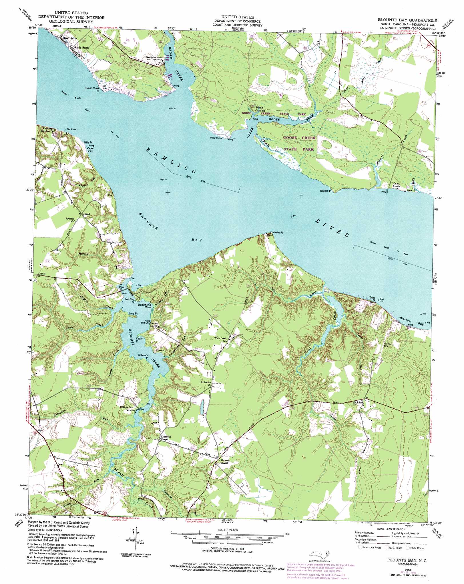
Blounts Bay Topo Map North Carolina
To zoom in, hover over the map of Blounts Bay
USGS Topo Quad 35076d8 - 1:24,000 scale
| Topo Map Name: | Blounts Bay |
| USGS Topo Quad ID: | 35076d8 |
| Print Size: | ca. 21 1/4" wide x 27" high |
| Southeast Coordinates: | 35.375° N latitude / 76.875° W longitude |
| Map Center Coordinates: | 35.4375° N latitude / 76.9375° W longitude |
| U.S. State: | NC |
| Filename: | o35076d8.jpg |
| Download Map JPG Image: | Blounts Bay topo map 1:24,000 scale |
| Map Type: | Topographic |
| Topo Series: | 7.5´ |
| Map Scale: | 1:24,000 |
| Source of Map Images: | United States Geological Survey (USGS) |
| Alternate Map Versions: |
Blounts Bay NC 1953, updated 1954 Download PDF Buy paper map Blounts Bay NC 1953, updated 1977 Download PDF Buy paper map Blounts Bay NC 1953, updated 1983 Download PDF Buy paper map Blounts Bay NC 1953, updated 1994 Download PDF Buy paper map Blounts Bay NC 2010 Download PDF Buy paper map Blounts Bay NC 2013 Download PDF Buy paper map Blounts Bay NC 2016 Download PDF Buy paper map |
1:24,000 Topo Quads surrounding Blounts Bay
Leggetts Crossroads |
Old Ford |
Farmlife |
Hoke |
Pike Road |
Grimesland |
Washington |
Bunyan |
Pinetown |
Pantego |
Wilmar |
Hackney |
Blounts Bay |
Bath |
Ransomville |
Vanceboro |
Ernul |
Edward |
Aurora |
South Creek |
Jasper |
Askin |
Reelsboro |
Bayboro |
Vandemere |
> Back to 35076a1 at 1:100,000 scale
> Back to 35076a1 at 1:250,000 scale
> Back to U.S. Topo Maps home
Blounts Bay topo map: Gazetteer
Blounts Bay: Bays
Blounts Bay elevation 0m 0′Buckhorn Cove elevation 0m 0′
Sparrow Bay elevation 0m 0′
Blounts Bay: Capes
Broad Creek Point elevation 1m 3′Cedar Point elevation 1m 3′
Hills Point elevation 2m 6′
Long Point elevation 2m 6′
Maules Point elevation 1m 3′
Ragged Point elevation 1m 3′
Red Bug Point elevation 0m 0′
Robinson Point elevation 0m 0′
Tripp Point elevation 5m 16′
Blounts Bay: Guts
Alligator Gut elevation 0m 0′Coon Gut elevation -1m -4′
Great Gut elevation 2m 6′
Martin Gut elevation 1m 3′
Yellowbank Gut elevation 0m 0′
Blounts Bay: Populated Places
Camp Hardee elevation 8m 26′Camp Leach elevation 0m 0′
Cotton Patch Landing elevation 0m 0′
Dinah Landing elevation 1m 3′
Gerard Landing elevation 0m 0′
Gilead elevation 10m 32′
River Acres elevation 1m 3′
Shady Banks elevation 1m 3′
Blounts Bay: Streams
Blounts Creek elevation 4m 13′Broad Creek elevation 0m 0′
Dupree Creek elevation 0m 0′
Flatty Creek elevation 0m 0′
Herring Run elevation 0m 0′
Jack Creek elevation 0m 0′
Lewis Gut elevation 0m 0′
Little Creek elevation 0m 0′
Mallard Creek elevation 6m 19′
Nancy Run elevation 0m 0′
Nevil Creek elevation 0m 0′
Sheppard Run elevation 0m 0′
Taylor Gut elevation 0m 0′
Upper Goose Creek elevation 0m 0′
Yeats Creek elevation 0m 0′
Blounts Bay digital topo map on disk
Buy this Blounts Bay topo map showing relief, roads, GPS coordinates and other geographical features, as a high-resolution digital map file on DVD:
Atlantic Coast (NY, NJ, PA, DE, MD, VA, NC)
Buy digital topo maps: Atlantic Coast (NY, NJ, PA, DE, MD, VA, NC)
 map DVD")