Ponzer Topo Map North Carolina
To zoom in, hover over the map of Ponzer
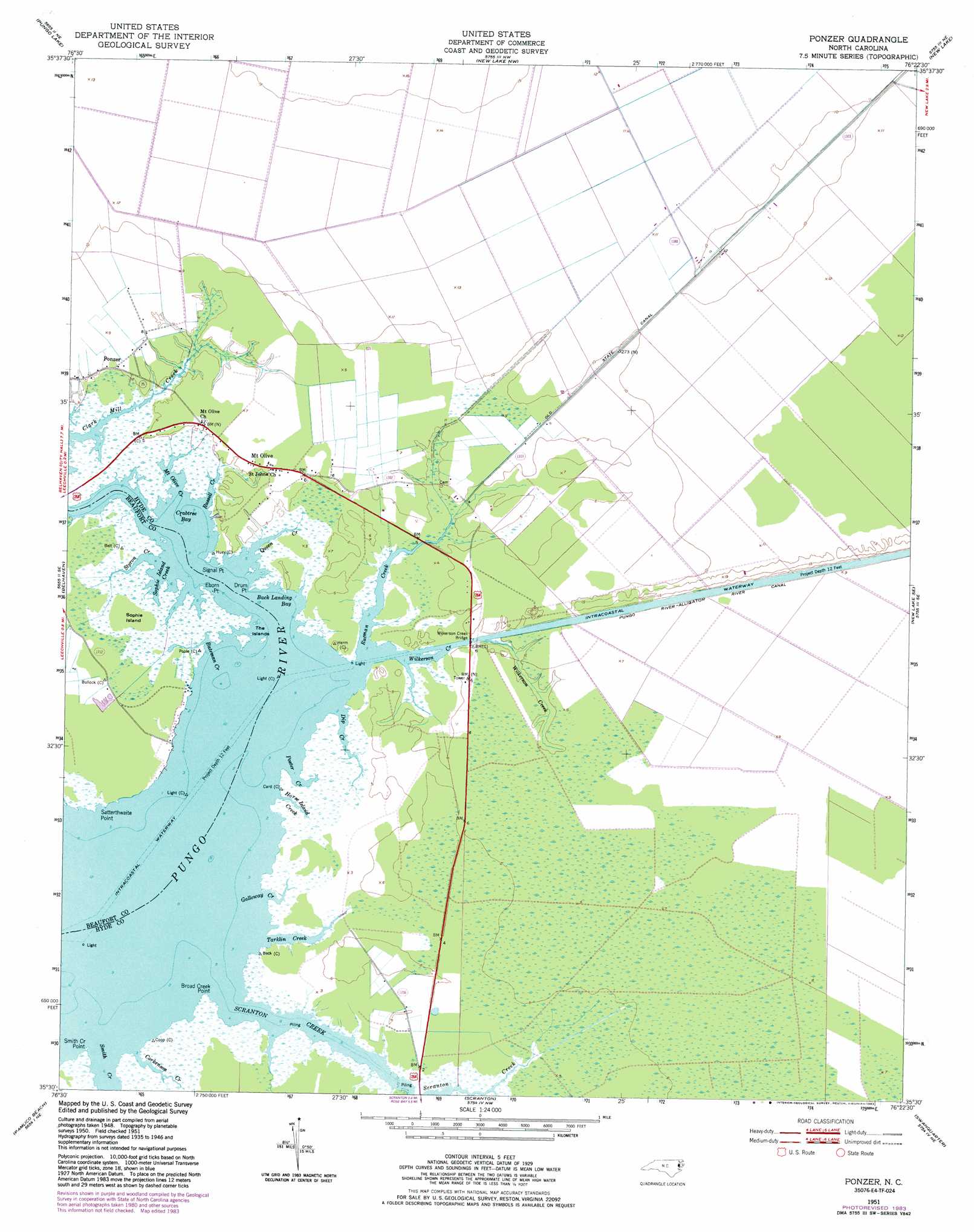
USGS Topo Quad 35076e4 - 1:24,000 scale
| Topo Map Name: | Ponzer |
| USGS Topo Quad ID: | 35076e4 |
| Print Size: | ca. 21 1/4" wide x 27" high |
| Southeast Coordinates: | 35.5° N latitude / 76.375° W longitude |
| Map Center Coordinates: | 35.5625° N latitude / 76.4375° W longitude |
| U.S. State: | NC |
| Filename: | o35076e4.jpg |
| Download Map JPG Image: | Ponzer topo map 1:24,000 scale |
| Map Type: | Topographic |
| Topo Series: | 7.5´ |
| Map Scale: | 1:24,000 |
| Source of Map Images: | United States Geological Survey (USGS) |
| Alternate Map Versions: |
Ponzer NC 1951, updated 1953 Download PDF Buy paper map Ponzer NC 1951, updated 1977 Download PDF Buy paper map Ponzer NC 1951, updated 1983 Download PDF Buy paper map Ponzer NC 2010 Download PDF Buy paper map Ponzer NC 2013 Download PDF Buy paper map Ponzer NC 2016 Download PDF Buy paper map |
1:24,000 Topo Quads surrounding Ponzer
Plymouth East |
Roper South |
Creswell |
Creswell Se |
Scotia |
Pike Road |
Pungo Lake |
New Lake Nw |
New Lake |
Fairfield Nw |
Pantego |
Belhaven |
Ponzer |
New Lake Se |
Fairfield |
Ransomville |
Pamlico Beach |
Scranton |
Swanquarter |
New Holland |
South Creek |
Lowland |
Pamlico Point |
Great Island |
Bluff Point |
> Back to 35076e1 at 1:100,000 scale
> Back to 35076a1 at 1:250,000 scale
> Back to U.S. Topo Maps home
Ponzer topo map: Gazetteer
Ponzer: Bays
Back Landing Bay elevation 0m 0′Crabtree Bay elevation 0m 0′
Poster Creek elevation 0m 0′
Sophie Island Creek elevation 0m 0′
Ponzer: Bridges
Wilkerson Creek Bridge elevation 0m 0′Ponzer: Canals
Old State Canal elevation 2m 6′Ponzer: Capes
Broad Creek Point elevation 0m 0′Drum Point elevation 1m 3′
Eborn Point elevation 0m 0′
Satterthwaite Point elevation 0m 0′
Signal Point elevation 1m 3′
Smith Creek Point elevation 0m 0′
Ponzer: Islands
Sophie Island elevation 1m 3′The Island elevation 0m 0′
Ponzer: Populated Places
Mount Olive elevation 2m 6′Ponzer elevation 2m 6′
Ponzer: Streams
Bateman Creek elevation 0m 0′Corkenson Creek elevation 0m 0′
Dip Creek elevation 0m 0′
Galloway Creek elevation 0m 0′
Horse Island Creek elevation 1m 3′
Mount Olive Creek elevation 0m 0′
Queen Creek elevation 0m 0′
Russell Creek elevation 0m 0′
Rutman Creek elevation 0m 0′
Scranton Creek elevation 0m 0′
Smith Creek elevation 0m 0′
Styron Creek elevation 0m 0′
Tarklin Creek elevation 0m 0′
Wilkerson Creek elevation 0m 0′
Ponzer digital topo map on disk
Buy this Ponzer topo map showing relief, roads, GPS coordinates and other geographical features, as a high-resolution digital map file on DVD:
Atlantic Coast (NY, NJ, PA, DE, MD, VA, NC)
Buy digital topo maps: Atlantic Coast (NY, NJ, PA, DE, MD, VA, NC)
 map DVD")