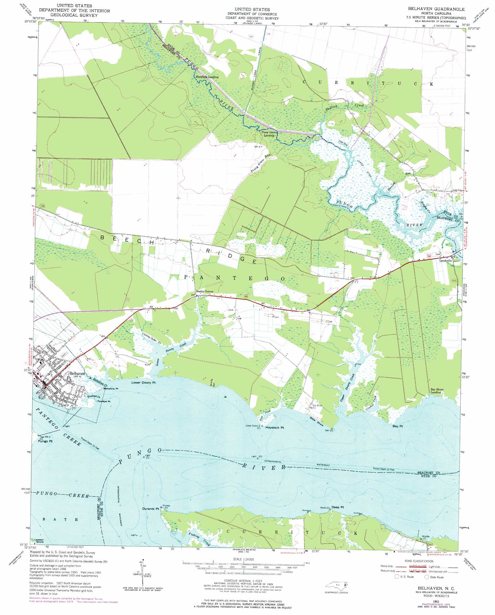
Belhaven Topo Map North Carolina
To zoom in, hover over the map of Belhaven
USGS Topo Quad 35076e5 - 1:24,000 scale
| Topo Map Name: | Belhaven |
| USGS Topo Quad ID: | 35076e5 |
| Print Size: | ca. 21 1/4" wide x 27" high |
| Southeast Coordinates: | 35.5° N latitude / 76.5° W longitude |
| Map Center Coordinates: | 35.5625° N latitude / 76.5625° W longitude |
| U.S. State: | NC |
| Filename: | o35076e5.jpg |
| Download Map JPG Image: | Belhaven topo map 1:24,000 scale |
| Map Type: | Topographic |
| Topo Series: | 7.5´ |
| Map Scale: | 1:24,000 |
| Source of Map Images: | United States Geological Survey (USGS) |
| Alternate Map Versions: |
Belhaven NC 1951, updated 1953 Download PDF Buy paper map Belhaven NC 1951, updated 1972 Download PDF Buy paper map Belhaven NC 1951, updated 1977 Download PDF Buy paper map Belhaven NC 2010 Download PDF Buy paper map Belhaven NC 2013 Download PDF Buy paper map Belhaven NC 2016 Download PDF Buy paper map |
1:24,000 Topo Quads surrounding Belhaven
Plymouth West |
Plymouth East |
Roper South |
Creswell |
Creswell Se |
Hoke |
Pike Road |
Pungo Lake |
New Lake Nw |
New Lake |
Pinetown |
Pantego |
Belhaven |
Ponzer |
New Lake Se |
Bath |
Ransomville |
Pamlico Beach |
Scranton |
Swanquarter |
Aurora |
South Creek |
Lowland |
Pamlico Point |
Great Island |
> Back to 35076e1 at 1:100,000 scale
> Back to 35076a1 at 1:250,000 scale
> Back to U.S. Topo Maps home
Belhaven topo map: Gazetteer
Belhaven: Airports
Pungo District Hospital Airport elevation 1m 3′Riverside Campground Airport elevation 1m 3′
Belhaven: Bays
Battalina Creek elevation 0m 0′Flax Pond elevation 0m 0′
Tooleys Creek elevation 0m 0′
Belhaven: Beaches
Bible Shore elevation 1m 3′Lawson Shore elevation 0m 0′
Belhaven: Canals
Lowes Ditch elevation 0m 0′Belhaven: Capes
Battalina Point elevation 0m 0′Bay Point elevation 1m 3′
Deep Point elevation 1m 3′
Durants Point elevation 0m 0′
Haystack Point elevation 1m 3′
Lower Dowry Point elevation 1m 3′
Pungo Point elevation 1m 3′
Tooleys Point elevation 0m 0′
Belhaven: Guts
Cow Gut elevation 0m 0′Sandy Gut elevation 0m 0′
Belhaven: Islands
Gaylords Island elevation 2m 6′Belhaven: Populated Places
Belhaven elevation 0m 0′Haslin Corner elevation 2m 6′
Hoophole Landing elevation 0m 0′
Leechville elevation 1m 3′
Piney Grove Landing elevation 0m 0′
Belhaven: Ridges
Arnolds Ridge elevation 2m 6′Beech Ridge elevation 3m 9′
Chinquapir Ridge elevation 2m 6′
Belhaven: Streams
Clark Mill Creek elevation 1m 3′Crooked Creek elevation 1m 3′
Cutting Sedge Creek elevation 0m 0′
Fishing Creek elevation 0m 0′
Herring Run elevation 1m 3′
Herring Run elevation 1m 3′
Knights Creek elevation 1m 3′
Lower Dowry Creek elevation 0m 0′
Pantego Creek elevation 0m 0′
Piney Grove Run elevation 0m 0′
Pungo Creek elevation 0m 0′
Shallop Creek elevation 0m 0′
Upper Dowry Creek elevation 0m 0′
Belhaven: Swamps
Pantego Swamp elevation 3m 9′Belhaven digital topo map on disk
Buy this Belhaven topo map showing relief, roads, GPS coordinates and other geographical features, as a high-resolution digital map file on DVD:
Atlantic Coast (NY, NJ, PA, DE, MD, VA, NC)
Buy digital topo maps: Atlantic Coast (NY, NJ, PA, DE, MD, VA, NC)
 map DVD")