Jasper Topo Map North Carolina
To zoom in, hover over the map of Jasper
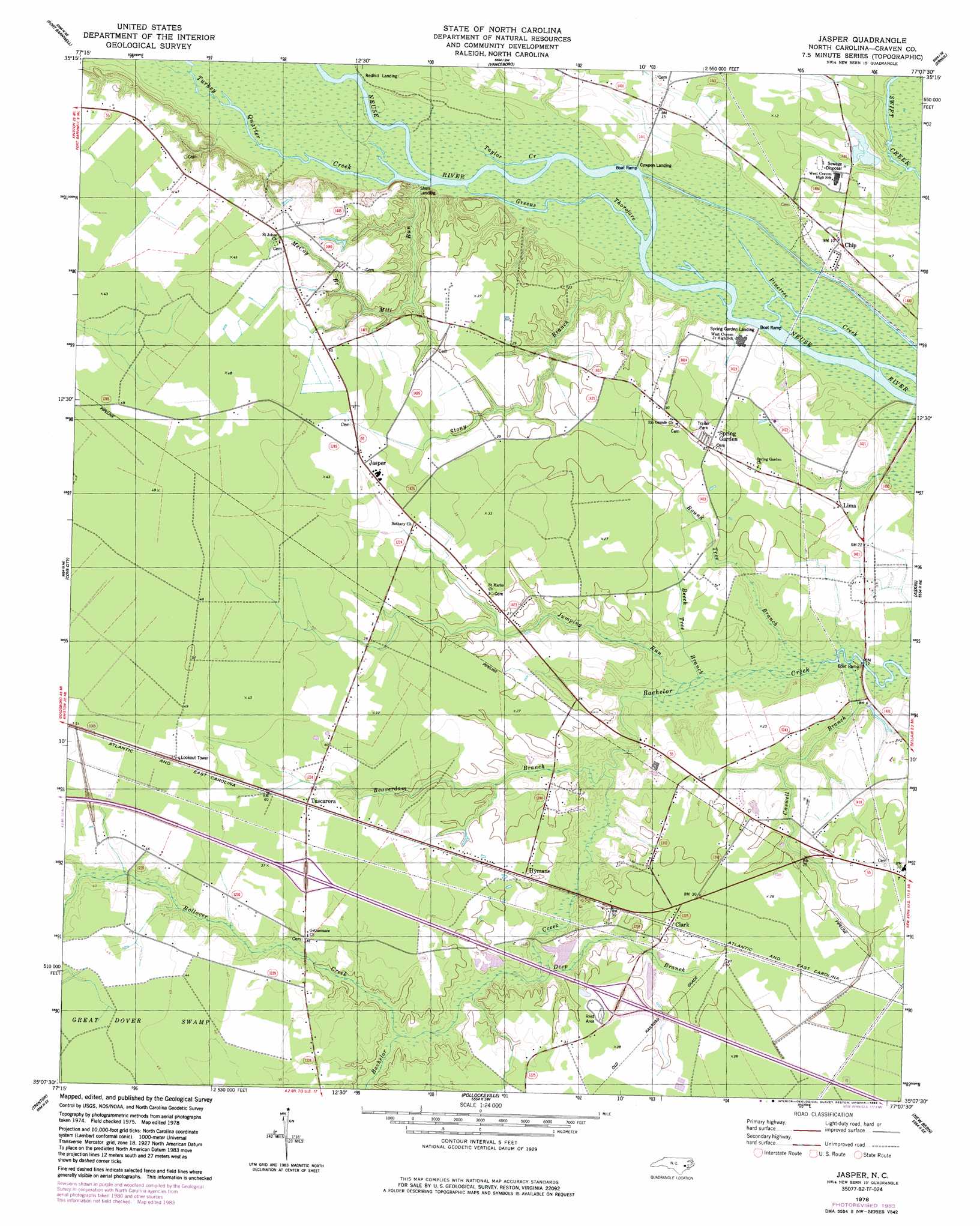
USGS Topo Quad 35077b2 - 1:24,000 scale
| Topo Map Name: | Jasper |
| USGS Topo Quad ID: | 35077b2 |
| Print Size: | ca. 21 1/4" wide x 27" high |
| Southeast Coordinates: | 35.125° N latitude / 77.125° W longitude |
| Map Center Coordinates: | 35.1875° N latitude / 77.1875° W longitude |
| U.S. State: | NC |
| Filename: | o35077b2.jpg |
| Download Map JPG Image: | Jasper topo map 1:24,000 scale |
| Map Type: | Topographic |
| Topo Series: | 7.5´ |
| Map Scale: | 1:24,000 |
| Source of Map Images: | United States Geological Survey (USGS) |
| Alternate Map Versions: |
Jasper NC 1978, updated 1979 Download PDF Buy paper map Jasper NC 1978, updated 1983 Download PDF Buy paper map Jasper NC 2010 Download PDF Buy paper map Jasper NC 2013 Download PDF Buy paper map Jasper NC 2016 Download PDF Buy paper map |
1:24,000 Topo Quads surrounding Jasper
Ayden |
Gardnerville |
Wilmar |
Hackney |
Blounts Bay |
Grifton |
Fort Barnwell |
Vanceboro |
Ernul |
Edward |
Dover |
Cove City |
Jasper |
Askin |
Reelsboro |
Phillips Crossroads |
Trenton |
Pollocksville |
New Bern |
Upper Broad Creek |
Jacksonville Nw |
Jacksonville Ne |
Maysville |
Catfish Lake |
Havelock |
> Back to 35077a1 at 1:100,000 scale
> Back to 35076a1 at 1:250,000 scale
> Back to U.S. Topo Maps home
Jasper topo map: Gazetteer
Jasper: Channels
Greens Thorofare elevation 0m 0′Jasper: Populated Places
Chip elevation 2m 6′Clark elevation 9m 29′
Hymans elevation 8m 26′
Jasper elevation 11m 36′
Lima elevation 5m 16′
Red Wood Terrace Mobile Home Park elevation 8m 26′
Spring Garden elevation 8m 26′
Tuscarora elevation 12m 39′
Jasper: Streams
Beaverdam Branch elevation 1m 3′Beech Tree Branch elevation 0m 0′
Caswell Branch elevation 0m 0′
Deep Branch elevation 3m 9′
Jumping Run elevation 0m 0′
McCoy Branch elevation 6m 19′
Mill Branch elevation 14m 45′
Mill Run elevation 0m 0′
Rollover Creek elevation 4m 13′
Round Tree Branch elevation 0m 0′
Stony Branch elevation 0m 0′
Taylor Creek elevation 0m 0′
Turkey Quarter Creek elevation 0m 0′
Jasper digital topo map on disk
Buy this Jasper topo map showing relief, roads, GPS coordinates and other geographical features, as a high-resolution digital map file on DVD:
Atlantic Coast (NY, NJ, PA, DE, MD, VA, NC)
Buy digital topo maps: Atlantic Coast (NY, NJ, PA, DE, MD, VA, NC)
 map DVD")